How to deal with historic data in OSM?

Re : Changeset: 144978376 | OpenStreetMap

I use an OSM based map in my handheld GPS unit here in the UK. The map on my GPS displays not only roads and tracks but also has symbology to display what are known, here in England, as Public Rights of Way (PROW). So my (selfish) aim when editing OSM is to accurately record PROWs.

The village of Haxey has a disused railway line that runs between Haxey and Epworth five miles to the north. A section of this former railway has been designated as a PROW in the form of a bridleway. For those not familiar with the term it is a legal definition in English law that means that members of the public have a legal right to travel the bridleway on either foot, horse or cycle. It does not imply anything else.

Before my edit the bridleway was entered in OSM as feature type = abandoned railway.
Please confirm that the feature type field just applies a preset number of tags and plays no other part in the OSM database?


Screenshot 2023-12-11 at 07.04.06

The original rail line ran on top of an Embankment and over two bridges that passed over other tracks. On the ground only a single bridge remains and at the site of the second the bridleway drops off the embankment to cross a track before climbing up the other side to rejoin the old route.

The OSM entry I found ignored the missing bridge and the on/off tracks descending from the embankment. Also for most of the section of interest two other ways had been added, one trying to describe the bridleway and the second a mtb route.

My solution was to delete the two unnecessary ways, break the railway at the missing bridge, add new ways to describe the on off tracks at the missing bridge and also in Haxey and attempt to ensure that the tags were consistent. This involved a lot of disconnecting, breaking and reconnecting of Ways and in the end I have failed in that the symbology of the Way changes as it crosses the bridge that I added. Unfortunately I do not know how to find connection points using the web editor to check the tagging of sections. It was and is a slow fiddly process.

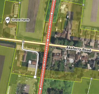
My editing was complicated by trying to preserve the original historic data. I find myself asking why is it stored in OSM at all. In my view a map is for navigating and should describe what exists on the ground. As an example the screen shot below shows the same Way half a mile south of Haxey. In the past there was a rail bridge over the road but it was removed decades ago. Just north of the bridge the Way passes through a house.

Screenshot 2023-12-11 at 07.31.41

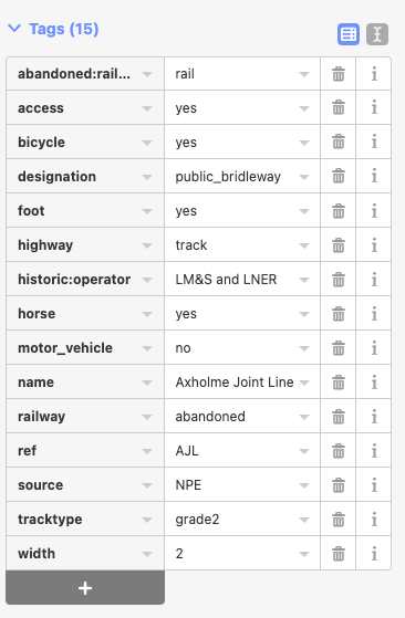
I struggled with deciding on how to tag a bridleway and in the end settled on “designation=public_bridleway” along with “access=yes”.

So how should I be editing data such as the Axholme Joint Line and does it have any place in a map used for navigation?

Sorry for the long post,

S

P.S.
Here is a screen shot of the tags after my edit:

You’re right - we generally don’t store historical data. The general exception is when the feature itself is still visible, even if not in use for its intended purpose. Abandoned railways tend to fall into this category, the cutting and elevated way is often still visible. Even if the tracks have been removed and trains have long since stopped travelling.

As your example illustrates, abandoned railways often find new leases of life - including as public rights of way.

You may find this wiki article useful: Access provisions in the United Kingdom - OpenStreetMap Wiki Particularly:

As you have seemingly done, you can still leave the abandoned:railway tags on the way and include new tagging features such as highway and designation.

Thanks for your reply and for confirming that I dhaven’t made to much of a mess of the edit, although I bet somewhere there is a historic railways society wringing their hands over the now broken abandoned railway.

1 Like

Where an old thing (railway) is changed to be a new thing (bridleway), it makes sense to add the new tags that make sense now and remove those that no longer do.

Unfortunately, not everyone does this, and I’m guessing that a previous mapper in that area might have left two essentially duplicate things. Looking a bit further to the north I can see this bridleway and this former railway. I suspect that they’re actually the same thing, so there should only be one object in OSM, not two (exactly as you’ve done further south).

When merging the two, I’d argue that the name “Axholme Joint Line” isn’t a current name, unless it is signposted as such in the present day, and “ref” similarly doesn’t apply. It absolutely makes sense to add railway=abandoned and/or abandoned:railway=rail to the bridleway because those are valid attributes of that bridleway, which is what exists now.

There is a sister project, OpenHistoricalMap, that can be used for mapping historic things.

1 Like

First of all, it’s great to see someone interested in PRoWs editing in this area. These are still poorly mapped in Lincolnshire and adjacent regions (image below is from 2018, but the situation today is not dissimilar):

Secondly, you are correct about current data and the on-the-ground rule. For complex reasons historical railways are a well-known exception. In part this is because railway enthusiasts are probably over-represented in the mapping community. I do find that in many places knowledge of the presence of a former railway can assist in interpreting what is on the ground currently (odd land parcels, development patterns, bridges, etc), so I don’t find such data wholly irrelevant.

Thirdly, your edits look fine, this is pretty much the regular way of keeping both sorts of information. Compare for instance one of my own in Leicestershire (although this also demonstrates one issue with the track and old railway-bed sharing ways.)

1 Like

Not far away I found this peculiar fence. It’s so long and straight, must be from the Roman Empire.

SomeoneElse : Looking at the links in your post I can confirm that there is only a single bridleway which again is part of the Axholme Greenway. I suspect there will be more as the the rail line forks and part of it is now a public footpath.

SK53 : I agree that the knowledge of the presence of a railway can be useful but I think you and SomeoneElse have confirmed that it is valid to break the such a Way when it has a new use and goes over bridges that no longer exist.

Your map is rather challenging! Is it a map that I can generate so that I can produce more detailed maps of specific areas. Also what is it comparing OSM PROW against?

1 Like