Hello everyone,
I’m totally new here but a friend recommended me to use OpenStreetMap for my project.
My project is to create a map where people can find the little free libraries around them, all around the world.
I initially started a map on GoogleMaps but people needs to register to add so items on my map.
So I would like to create a map that everybody can come and add or remove items that’s on it but I don’t know how to do it or if open street map is the right tools.
By “little free libraries”, do you mean something like a public bookshelf? If so, there is already a user friendly way to contribute them to OpenStreetMap on MapComplete. Contributors do need an OpenStreetMap account though as they should be contactable if anyone has questions about their edits and there are some terms to agree to.
At it’s heart OpenStreetMap is a database of “stuff you might put on a map”. If the sort of thing you want to map is not something that would fit well with what we do and don’t map then you can use OpenStreetMap as a background, but we would need more detail about what you are trying to do to make good recommendations about how to go about that.
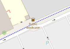
OpenStreetMap has established tagging for “little free libraries” under the more general tag of amenity=public_bookcase. Anyone can create a OSM account and then map the ones they know about.
The second half of your question is how people can easily find those libraries that are in the map database. There are tools that allow you to query but I suspect you are looking for a more accessible way to show the locations. I will leave that to others more familiar with tools for making custom maps. I hope those people will see and respond to this question.
Edit: For a “quick & dirty” you can use the OSM Turbo Overpass site to query where amenity=public_bookcase nodes are. And you can even show the output as a “interactive map”. Here are the public bookcases in the Los Angeles metro area: overpass turbo - map
This is exactly what OSM stands for and everybody is allowed to add any object to the database which is physically present “on the ground”. This also applies for “little libraries”, notwithstanding if those are real libraries where you can lend books or if you are talking about free book exchange stands which are mapped as public bookcase in OSM (as mentioned above).
There are different ways to contribute to OSM by using mobile devices or home computers. Look here for more details:
The problem with public bookcases is the fact that it is not possible to find them in a certain location in the standard map. They are rendered in the map with a little icon:
and you can even search for the term “public bookcase” which will produce thousands of search results
but there is no simple way to reduce the search to a certain area. There are tools to do that but they are not part of the OSM standard map and not easy to handle for anyone not being familar with OSM.
So you may look for someone to help you create a map display showing these bookcases. A good option would probably be OpenStreetBrowser which allows the display of various groups of items. These groups do not include public bookshelves at the time being but there is a group for cultural objects already where libraries and public bookshelves could probably be included. For more details have a look here:
+1 for this suggestion. MapComplete’s public bookcases theme sounds like the perfect fit to me. It even makes it easy to upload a picture, set the name, the kind of books it contains, etc.
I believe it’d also be possible to create a custom MapComplete layer for “Little Free Libraries”, if the OP is specifically interested in that brand/operator (rather than the more general “public bookcase” concept).
Thank you for you answer, yes it is exactly a map like the one on map complete that I want to create.
But I would like that people won’t need to create a specific account to add a bookshelf. There’s already a map like that on a website in France and nobody needs an account
If you want to contribute more than a note without an account I don’t think you will be able to store the information in OSM. (I don’t speak for the OSMF, but I know exceptions to this to be incredibly rare and limited in other ways.)
MapComplete is open source, as is the software that runs the OpenStreetMap so in theory you could run your own OSM clone with your own backend database. Projects like OpenHistoricalMap and OpenGeofiction do this, but for a project focussing on a single type of amenity this sounds beyond overkill to me.
There are ways to display other data on top of an OpenStreetMap based background, but I don’t know what to suggest for a means to populate that overlay. I assume that whatever you use will need good moderation tools.
Note that points added as an overlay through tools like these won’t be part of the OSM database and will only be visible in that specific map. The advantage of adding to OSM directly, while it does require setting up an account, is that data added becomes available to everybody. That in turn means that if something changes, there is a higher chance that another map user will notice.
Yes I guess so, I suppose that kind of collaboration is more suited to a group who know and trust each other to some extent. If the idea is that random members of the public can edit the data then there are a lot more issues to be considered.
.