How to change an intersection to a roundabout?

I have been encountering a few areas where typical intersections are being replaced with roundabouts. I had hoped there was a YouTube video showing how it is done and couldn’t find one. I also hoped there was a simple way to simply select each point at an intersection and have an option “Convert to Roundabout” that also doesn’t appear to exist.

All of my edits have been easy until encountering this. Can anyone point me to a step by step instruction on how to make the change? I know with a roundabout traffic goes to one way etc so I know I at least have to set that part.

1 Like

No instructions that I know of, but what I do is:

Split the existing roads at the old intersection & pull the last node back out of the way

Draw a new circular way with the same classification as the existing roads highway=primary / secondary etc, & also tagged with junction=roundabout

Make it a circle (O) & position it in the right spot

Reconnect the existing roads to the new roundabout, making sure that they don’t enter & leave the roundabout via the same node. Depending on the size of the roundabout, you may also need to split the connecting roads into 2 x one-way sections?

Hope that makes sense!

1 Like

Have a look at the Josm roundabout tool
https://wiki.openstreetmap.org/wiki/JOSM/Plugins/RoundaboutExpander

1 Like

Just want to add a note that @Fizzie41’s instructions are for a “proper” roundabout. If this is a miniroundabout then you just need to add highway=mini_roundabout to the existing intersection node. A direction=clockwise/anticlockwise tag may also be helpful for this too.

2 Likes

It is usually a bit more complicated than this. It often takes good knowledge of ways, tags on ways (such as oneway=yes, when true) and more, to get this totally correct.

Best is when there is accurate aerial / satellite imagery new enough to show the real “roundabout infrastructure elements” that exist in the real world. In some cases, if the imagery is “fine” enough, you can see lane markings, turn arrows, (et cetera) painted onto the pavement. You can also see bicycle and pedestrian crossings. Yes, it can be complicated to “build” these in OSM so that peds and bikes and autos all have their specific ways “painted ahead,” especially when there are route relations (like route=bicycle) included as part of the ways.

Persevere. You can do this. If you can’t, or feel you can’t, reach out to others on a specific intersection (even right here in Discourse). Give a link to the intersection and ask for specific help: “How do I correctly add cycleway lanes through this new roundabout, especially since there is a USBR (United States Bicycle Route, for example) along these ways?” There most certainly is a “right” method to do this, you can likely do this yourself, with a bit of study (it isn’t terribly difficult), though if you feel you can’t, asking a fellow OSM volunteer who is local, familiar with routing and infrastructure and so on, is likely to result in them or somebody like them saying “hey, happy to help you.”

And together, we keep building a damn good map.

1 Like

Any and all roundabout’s I have encountered I would think are proper, by that I mean, all go in a one way direction with traffic yielding when entering and leaving the roundabout in the same direction of travel. Do you mean by proper and mini_roundabout would be a single lane?

1 Like

I have been checking the aerial / satellite imagery and it hasn’t been updated yet. I don’t know how frequently it is updated and will keep checking. I figured I would take a run at it when it is updated. Then to be on the safe side after making the update just to be on the safe side have the update / change checked if I had any doubts it wasn’t correct.

I also figured I would find an existing roundabout and take a look at how it appears (tags etc). All of the roundabouts I have encountered so far don’t have any cycleway lanes.

2 Likes

I haven’t been using Josm even though I have it installed. All of my edits have been real basic, typically changing road surface from unpaved / gravel to asphalt or adding a couple of buildings.

I did just download and install the roundabout tool plugin.

1 Like

Little head scratcher, when installiing the plugin, it says the shortcut is Ctrl+Shft+R. Does not work here, but what does work is the shortcut advertised on the ‘More Tools’ menu of Ctrl+Alt+F7. Repeat this combination and the roundabout construction progresses.

The biggest pitfall on many roundabouts mappings are the breaking of all sorts of routes, be it road routes or public transport routes. Not tested how this plugin handles that but seen many manual mappings that end up with broken routes or the PT routes linked to the RB as loop around taking both the on and off ramps both sides as were it a roundtrip route when they aren’t. Takes work to get it right and sorting the positions in the routes.

I think mini_roundabouts only exist in a few jurisdictions, they have small “traversable” islands in the middle and usually have a special sign. For the most part you’re meant to treat them like “normal” roundabouts but you don’t generally indicate when departing them as they’re small enough that this is impractical. OSM tends to just record these as a single node as you can drive right over them even if you’re not meant to do that unless there’s no other option. If you’re not familiar with the term then they’re probably not a thing where you are.

If it’s on a route you drive fairly frequently you can often record gps traces on your phone and get a decent idea of the geometry without new imagery.

1 Like

With “newer, nicer, closer-to-state-of-the-art equipment,” yes. “At speed,” with a lot of “lesser” acquisition equipment (fewer GPS satellite channels, for example) this is an either ambitious or unattainable goal.

Of course, “this” (technology) is a moving target, and it depends on where in the world you live, what tech is getting rolled out in your country…a lot of factors.

Yes, seeing how plugins handle things like “routes” (of many types) is instructive. Doing so is complex and subtle for machine logic, and even humans ask for assistance and maybe even someone looking over their shoulder to correct it “does this look right?” when necessary (or thought to be). This is not always easy for everybody (it’s at least an “intermediate level” task, especially when route re-structuring is required) but it is certainly doable. It’s like fractions or algebra, many of us can map these, especially as we learn the rules and all the right boxes to check to say “we’re done, we got it all right here.”

Breaking PT routes, bicycle routes, bus routes…any type of route=* relation in OSM, not good. Sometimes we must pay careful attention to oneway=yes tags, or crossings, or lanes=* or…more. This is where OSM, when we are careful, can really shine brightly by “truly getting it right.” Let’s continue to do that, standing as tall as we can as we tag roundabouts. There are subtle issues in the wiki, in the real world, in how we map with particular tags in our data.

This is a big topic and “puffs out” as you blow more air, interest, people, perspectives, data structures, route elements into it. Think carefully about how we’re all going to do this better, going forward. And then, we shall.
My GPS creates a track as I travel so I do have the track / trace of the roundabout for the part I travel.

1 Like

Nice. Some acquisition devices do this quite accurately. Some, not so much.

There is much more to a “properly constructed” roundabout (in OSM, there is such a thing) than GPS-tracked lanes / traces, but that is a great start. Role tags on route relations, anyone? It’s a medium- or higher-level topic (restructuring a roundabout with route=* relations), but many mappers are up to it.

There is no one-solution-fits-all, but there are “better approaches.” Good to see us discussing these.

1 Like

An example of a “better approach,” something that might be put into the “best practices” container (for now) is:

For each way (road, sidewalk, cycleway…) which has an input for traffic of that mode into the roundabout, check that each way has every possible output (for that mode of travel) — “out” of the same roundabout. If so, and you didn’t “break” any existing relations tagged type=route which use elements “in” or “through” the roundabout, you might consider that a “better tagged” roundabout…as a kind of a Step 1. We can even improve from there, though let’s stick to Step 1 for now.

If a plugin does all that, I’m impressed.

OK, I’m listening.

The elfs were at work… they never tell, you are just to find out for yourself… went to map a small roundabout trialling the roundabout expander plugin and tried Ctrl+Alt+F7, hammering, nada happened. Then looked in the More Tools menu as memory is debole, the printed word isn’t and low and behold overnight the advertised shortcut changed to Ctrl+Shft+F7 and now it works.

Edit:The plugin has to be taught not to replicate any of the connecting street names, the convention being to not name roundabouts unless they have a dedicated/exclusive name of their own like Piazza del Nuovo.

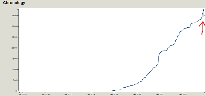
Edit2: Where is 'oneway_type=roundabout_flare documented? The RBE plugin adds this tag to the on/off ways of a roundabout. Search results | OpenStreetMap Taginfo has 3 uses in all of Italy (was that the plugin doing that?), 3.3K around the globe. History since 2017.

REX revisited, someone somewhere took a dislike to the noted tag addition by the JOSM plugin of oneway_type=roundabout_flare. The Chronology graph shows it took a dump recently but my lack of skill does not allow to see where this happened and query the person(s) who took an aversion.