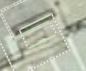
By switchback staircases I mean these:

Wouldnt let me upload more pictures so here are my ideas
(A) Should I map it as an unholy abomination like this:
I prefer “unholy abomination”, but that’s just me.
Am using A, but it doesn’t solve spiral/helical ramps in carparks or hillside vehicular access either. That has further implications on 3D buildings. For footbridges and stair access to vehicular bridge sidewalk, cf Bridge3D - OpenStreetMap Wiki has many problems, and doesn’t handle this situation yet.
repeat_on= requires proper evaluation, to not cause routing straight through the top and bottom. It has further problems when the start and end are stacked, including via entrance= + repeat_on . 2 highway= connecting to one will simply “bounce through” it (akin to a ball hitting a wall), treating it as a corner.
In theory, there should ideally be an area feature for these, similar how there are highway=elevator points. area:highway=steps alone expresses a single stair “surface”, and doesn’t include landings which would be area:highway=footway . There exist indoor= + stairs=yes but naturally it doesn’t apply outside what’s considered “indoors”, and indoor= is basically all about not really routable areas now.
So what I thought before there should an area eg highway=staircase similar to =elevator points to abstract them. “Stairwell” might be less confusing against linear =steps , but the term is for indoors.
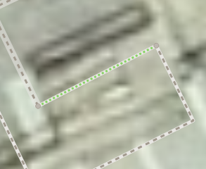
(B) Or just map it like straight stairs:
Are there any tags that would help?
Thanks
It looks like the stair is only connecting two floors with each other, and not multiple at once. In that case a straight line is sufficient. Here’s a similar example of a spiraling stair that has been mapped as a simple U-shape. One obvious drawback is that the stairs have an unrealistic high step_count for how short they are. ¯\(ツ)/¯