I’ve read the wiki pages on lanes and street parking, but I don’t see where this specific situation is covered. In my city, some streets have two or more lanes painted in each direction; however, parallel parking is also allowed; however, there is no extra space on the side for said parallel parking. In other words, the parallel parking obstructs drivers’ ability to use that outer lane.
I understand how to tag a two-lane street w/ parallel parking on both sides:
| kurb | Lane 1 | Lane 2 | Lane 3 | Lane 4 | kurb |
|---|---|---|---|---|---|
| kurb | parallel parking | backward | forward | parallel parking | kurb |
lanes=2
parking:both=lane
parking:both:orientation=parallel
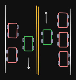
But what if Lanes 1 and 4 are explicitly marked as travel lanes (in the US this means they are marked w/ white dashed lines w/ a double-yellow in the center) and Lanes 1 and 4 also allow for parallel parking without any extra space for said parallel parking, i.e., if somebody parallel parks in that lane, you have to change lanes in order to move forward?
| kurb | Lane 1 | Lane 2 | Lane 3 | Lane 4 | kurb |
|---|---|---|---|---|---|
| kurb | backward and/or parallel parking | backward | forward | forward and/or parallel parking | kurb |
Option 1:
lanes=2
parking:both=lane
parking:both:orientation=parallel
- Pros: Represents the number of guaranteed travel lanes and enables data consumers to guesstimate the road’s width with greater confidence.
- Cons: Under represents the maximum number of travel lanes available in stretches where no vehicles are parallel parked.
Option 2:
lanes=4
parking:both=lane
parking:both:orientation=parallel
- Pros: Represents the maximum possible number of travel lanes where no vehicles are parallel parked.
- Cons: Overstates the number of guaranteed travel lanes where vehicles are parallel parked; might cause data consumers to incorrectly guesstimate the road’s width.
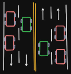
Some real life examples in Richmond, Virginia (except w/ a total of three explicitly marked lanes instead of four):
- West Leigh Street eastbound, east of Brook Road - way 38256518 in OSM, and here is a Mapillary image.
- East Broad Street - way 692873425. In the Mapillary imagery, two SUVs are parallel parked on the opposite side of the road. On this stretch, three lanes are explicitly marked, with extra space for parallel parking on the right side of the road, but on the opposite side of the road, people are parallel parked even though it is explicitly marked as two travel lanes, and there is no extra space for the parallel parked vehicles. I believe those two SUVs are parked legally.
I can’t find any documentation on this specific scenario. I’m also having a hard time thinking of what specific tags I could query in Overpass to find other real world examples.
Thus, I turn to the community: How would you tag this situation and why? Do you know of any other real world examples I can examine? Can you think of any tags that would be specific to this situation so that I could query Overpass to find other examples?
Thanks in advance!