My private driveway is showing incorrectly as a road. We have delivery drivers and others constantly trying to cut through. I can’t figure out how to change it. Is it even possible?
It depends on what they’re using as a gps app provider. If it’s here maps (very likely) then all I can say is good luck with that. It takes an act of congress for them to approve any edits.
If it’s incorrect in OSM, then you might want to use the edit button at the top left when logged in. You can then mark the road and edit its tags directly.
If you aren’t able to do that or don’t know how, you can instead point us to the specific way by linking to it (copy the url when you are looking at your driveway on the map).
As for that, we can’t make any guarantees that it won’t happen again. But if they happen to use an app based on OSM (with reasonable update cycles), they may be routed in a different way.
3 Likes
We don’t altogether delete roads, when they actually exist on the ground: Why we won't delete roads on private property - OpenStreetMap Wiki
However, it can be marked as access=private, which “should” prevent routers from directing traffic through there.
7 Likes
Agree! Other tagging should include:
highway=service
service=driveway
Having your driveway in OSM may actually help delivery people get your packages to you, as well as the other benefits outlined in the link provided by @Fizzie41
5 Likes
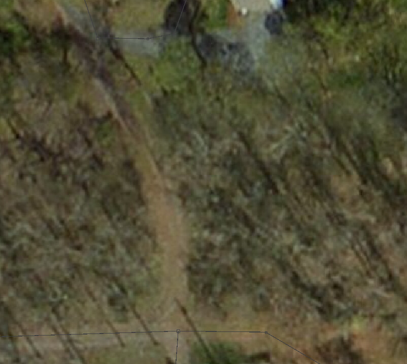
I appreciate all the advice and feedback. To be clear, this is not a road. You will see Lime Kiln Road and Grey Fox Ln. Where it says Gray Fox Lane, it is actually a driveway. At the top of the driveway, you will see red lines (Not sure what they mean), then Grey Fox Lane again. That is Gray Fox Lane above the red lines. The house on the left and right of NOT Grey Fox Lane are house number 38750 and 38756 Lime Kiln Road and this is a shared driveway for those 2 houses. It is possible to drive through the driveway onto Grey Fox but there is a farm gate there and its usually closed. Delivery drivers, especially for the A company with the blue vans, have map apps that show Grey Fox as all the way through. Here is the link: (OpenStreetMap)
The red dashes on the standard OpenStreetMap map represent a path, not a road. No router should direct delivery vans over a path. And no map should display it as if it was a road. So I wonder if the van drivers you refer to are really using OSM data.
OpenStreetMap could likely be improved by tagging the relevant sections as driveway as explained above, and removing the name if it is not right. But as I said, that might not help if the issue is not with OSM data to start with.
I was able to make the edits and really appreciate your reply. I had no idea what I was doing but I was able to figure it out. Thank you very much!
Nice work on the driveway, but it looks like you deleted the path that went from the driveway to Grey Fox Lane. Imagery suggests that it exits. Like the driveway, it probably would be better to mark it access=private
1 Like
You’re right, it does exist. I will see if I can put it back and mark it private. I’m a little confused about how this works though. I see the changes I made when I’m in edit mode, but it still looks like it used to when I’m not in the editor.
2 Likes
The map tiles take some time to update. Depends on zoom and you refreshing your browser cache.
Congrats on updating the map ![]()
1 Like
It takes a few minutes before the renderer sees the new changes. You can use Ctrl+R to refresh your browser cache and get the new tiles. Without that, it can take several hours and may produce fragments if parts of the cache get updated before others. But that’s a browser thing, nothing to do with the website. The changes are live (almost) immediately after upload.
That’s how we learn ![]() Thank you for your contribution, it’s very much appreciated!
Thank you for your contribution, it’s very much appreciated!
1 Like
Just FYI most delivery driver software uses other types of map data. Typically Here or TomTom. Here is notorious for having terrible moderation and contributions. It’s so bad that I simply refuse to contribute to them at all anymore.
Glad people were able to help you fix the issue.
It seems like the name for that driveway came from an old import of tiger road data.
but the houses on said driveway have the correct street name attached to them, so people trying to find your address will be able to.
Good luck with the delivery drivers. As people have mentioned, they are probably using different navigation providers. For example Here Maps is wrong ( HERE WeGo) as well as TomTom (Plan.TomTom.com)
It’s most likely going to be much harder getting things fixed there, so you might need a sign showing that the driveway is a dead end ![]()
1 Like