How and where to send information about a dangerous path suggested by OSM?

Hello everybody!

A I am new here: How and where can I notify someone about a dangerous route?

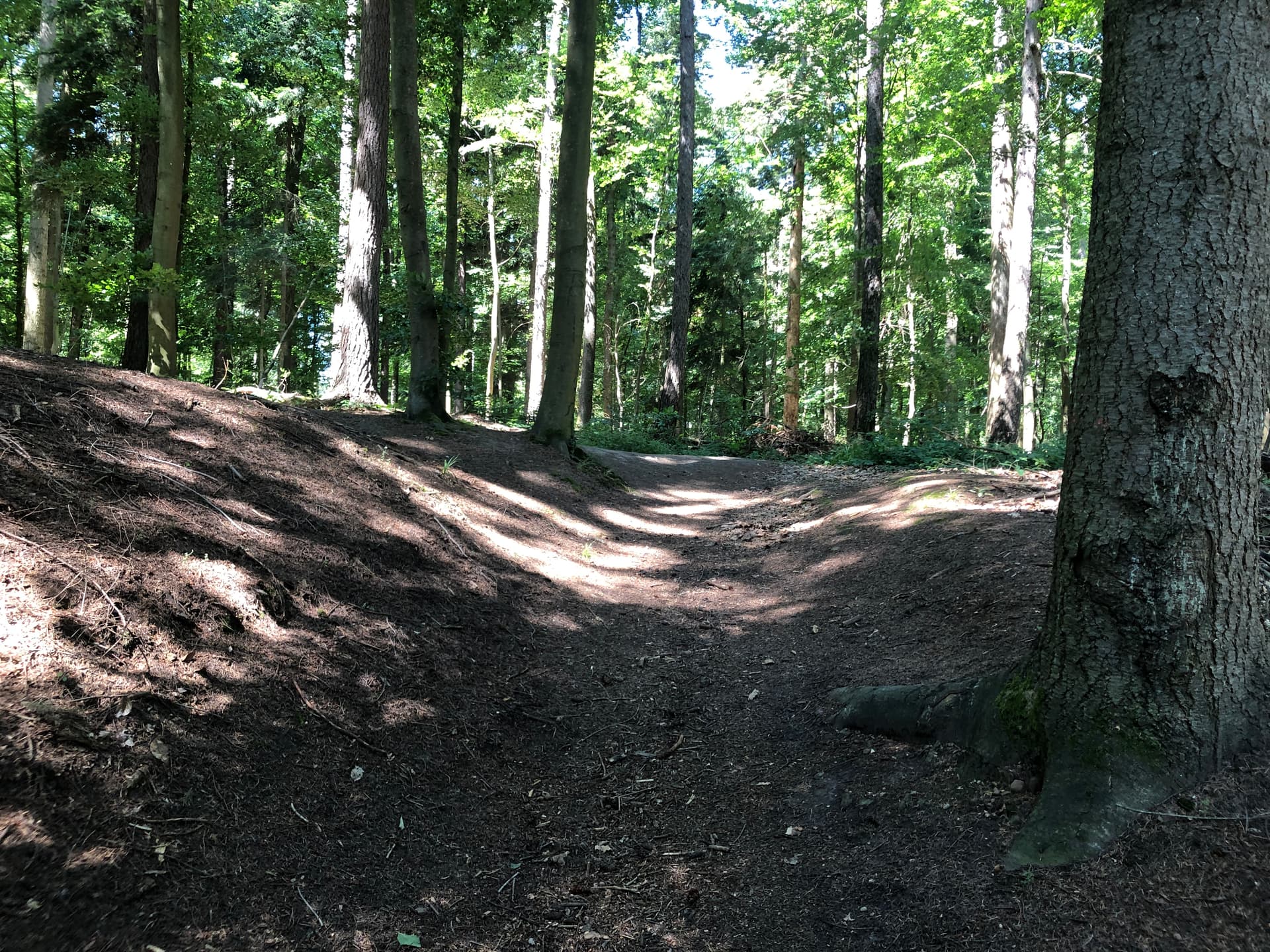
Background: I use the Bosch Flow app, which uses OSM, with my e-bike. One can tell it to use a “daily” route (as fast as possible, i.e. to work and back), “leisure” (nice bike ways) and offroad (named “Stock & Stein” in German). Usually, I use the offroad settings because I love do bike through the forests here, where there are perfectly safe ways. Otherwise, the bike would lead me straight to the larger streets with special bike ways beneath, but I want to stay in the forest.

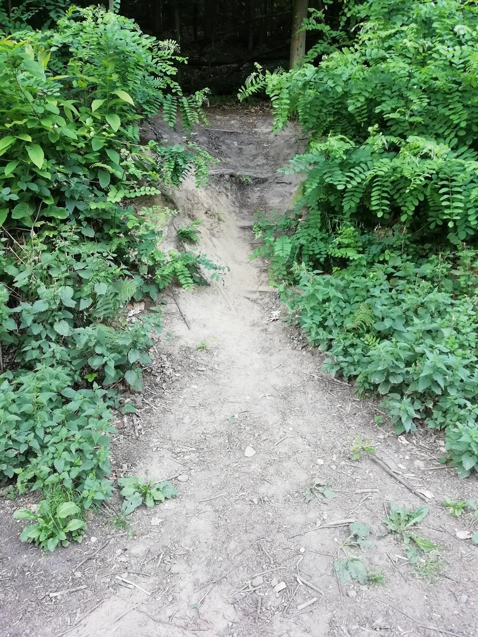
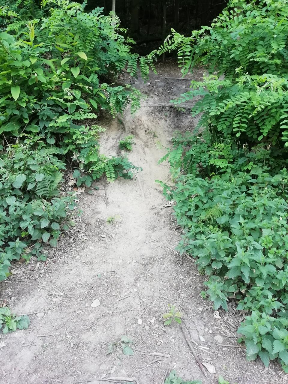
This worked quite fine for 1900 km driven. Three weeks ago, however, the bike insisted I should follow a way named “Eselspfad”. This goes kind of steeply downwards, but perfectly safe at first, because it is a quite fine forest ground, safely to drive down in a slow way. However, 20 m further, the way turns into a very steep one, which you cannot see from above, and, worse, that way has “stairs” with 10 - 20 cm step height. Maybe a very experienced mountain biker may manage this, but even my co-worker, which is a mountain biker, said, he would not go down this way using his mountain bike.

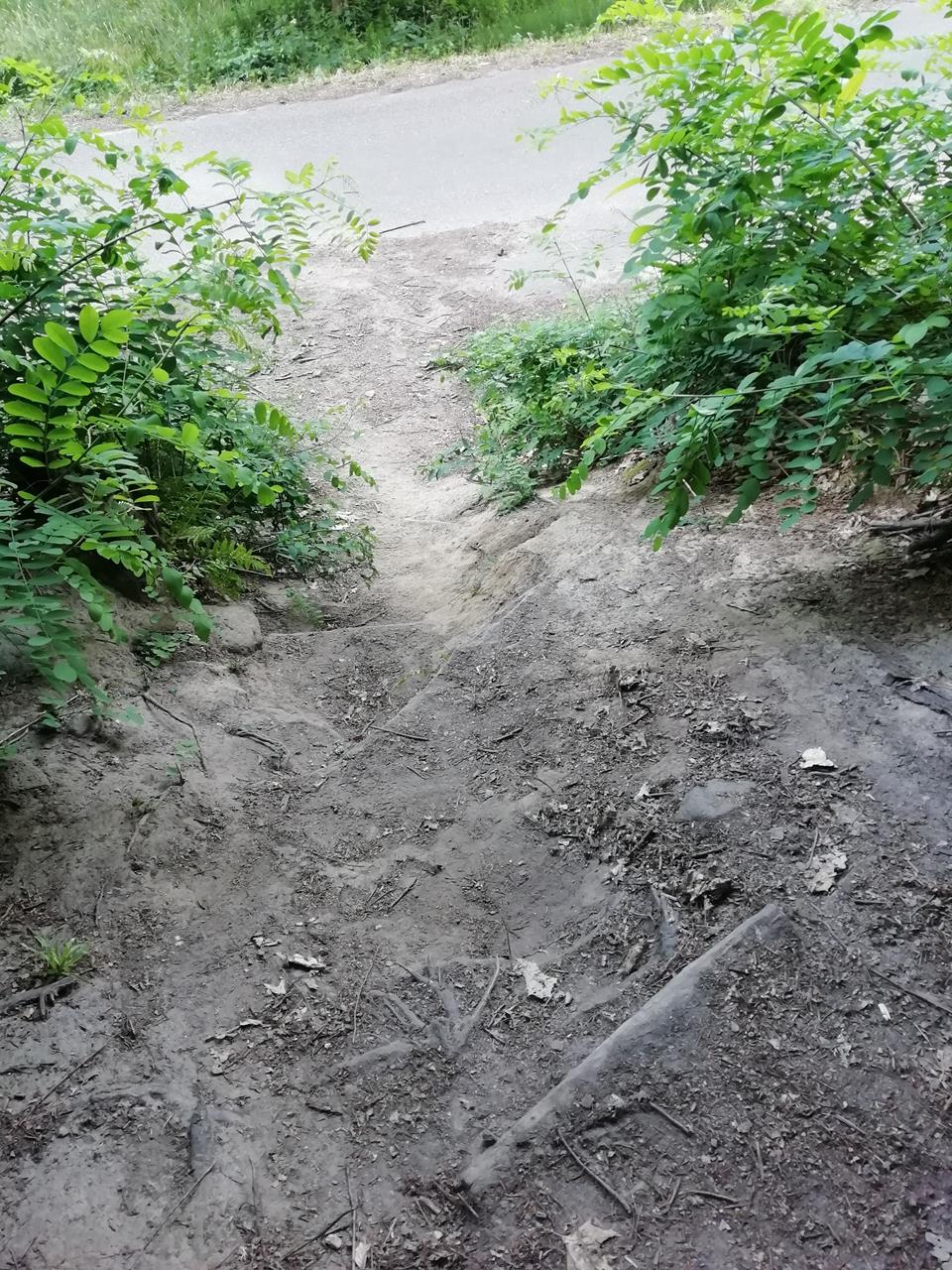
To make the long story short: When you arrive at that very steep part (which you do not see in advance), it is too late. I could not stop and things ended as they had to end: I went over the bike, landed on the forest ground, and the bike on me. Nothing broken (what surprised me), but seriously injured for weeks to go. And: 10 m further down the way, the steps would be 30 - 40 cm high, and you would land on a street instead on (relatively soft) forest ground.

I vote for either no longer offering this path for any bike, or at least flag it to be (very) dangerous. I have tracked the path and can provide the GPS coordinates. But how and where to contact someone?

Best regards, and a warm Thank You for all the work which has been put into OSM,
Stefan Falk

12 Likes

Good to see you.
And thank you for your willingness to reach out to ensure the accuracy of the information.

If you don’t have an OSM account, you can use the “notes” feature in the iD editor and ask them to reflect the information (but it might take a while).
If you do have an OSM account, there are ways to indicate the smoothness or difficulty of a path within the path(highway) properties.

  • mtb:scale=*
  • trail_visibility=*
  • smoothness=*
  • sac_scale=*
  • mtb:scale:imba=*

Find information on the properties you need in the OSM wiki.

4 Likes

Hi, I’m sorry to hear about your accident and hope you’re well again.

There is no central OSM authority to fix such things. What you can do:

  1. Locate the path on https://www.openstreetmap.org. In the menu on the right, select “map levels” (I work with the German version, the terms may be slightly different), activate “notes/errors”, zoom in, right click on the path, select “new note” and describe the problem. It may take a while until this gets addressed.

  2. Post a link to the path (zoom in as far as possible, then copy the link) and I’ll have a look at the tags.

  3. Learn to edit in OSM using the iD editor and do it yourself.

5 Likes

Been there, done that and a 180. Scaletta di Ferro (Iron ladder a route for iron man) at Bocca di Valle, but not mapped as steps just as path without grading, incline or anything. Only for MTB descent so it should be tagged 1 way too but it wasn’t so on the way up Bosch/Komoot wanted to sent me powering the mountain side and on the way back… well had wised up on this shortcut reducing the descend by about half a mile, a long hairpin. With skills and MTB knowledge it’s relatively easy to change and then a 10 month wait as Bosch does not update their maps very often. Komoot more frequent.

PS: Just see someone changed path name to mtb:name, but stilll no mtb ratings. It’s invisible from above, 365 days below dense canopy.

Hello everybody,

Thank you all very much for your answers! Before I do something wrong, I would prefer if somebody could remove or flag the “Eselspfad” at the following coordinates:

N 48° 51’ 20.45"
O 8° 19’ 54.33"

The coordinates are the middle of that path. If I should do anything else, please tell me. Thanks again.

Best Regards,
Stefan Falk

1 Like

Which is this in modern money.

As I write this, the last edit was 9 years ago. mtb:scale=1 is documented here.

If you think the Bosch app shouldn’t have sent you down something like that picture, then as a Bosch customer you’ll need to tell them that their app is making inappropriate suggestions. If they are confused, ask them to say hello here and people will be able to help.

Alternatively, if mtb:scale=1 underestimates the severity of the path, then it’s possible to edit it and change it to a different number. Whether the Bosch app will understand that is a different matter.

8 Likes

Hello again,

Thanks for the suggestion to contact Bosch directly. I will do this in parallel and link them to this thread.

Best Regards,
Stefan

4 Likes

Can you post a photo? Maybe it would qualify as highway=steps

8 Likes

On the topic of Bosch & OSM https://twitter.com/sp8962/status/1649844434442280961?t=FsGaNp1l028TGmQ2l-sMEw&s=19

In any case echoing the other commenters: fix the tagging of the relevant stretch and all will be good.

2 Likes

Routing Link: OpenStreetMap

Suggestion is to add the highway=steps and bicycle=dismount.

1 Like

Just for the avoidance of doubt, that’s one of the three bicycle routers (with very “default” defaults) on osm.org. The other two avoid the problematic section.

1 Like

highway=steps is for artificial steps on a foot path and bicycle=dismount, while intuitive, is for (legal) access. I’d suggest to either remove mtb:* in favor of sac_scale or increase mtb:scale to 2 or 3, based on the above description. Maybe also add smoothness, trail_visibility and mtb:description.

@Stefan_Falk: since you’ve been there, can you help with choosing appropriate tags?

DE:Mountain_biking

1 Like

Hello everybody,

My coworker was there with his mountain bike, but did not drive through the Eselspfad. He took photos from the street where the path ends. That is the part from which I would say, you can’t but end in a serious crash. Myself fell about 10 m earlier, from where I have no photo, unfortunately. If it is reasonable important, I could go there again and take more photos, but this would take a while.

This is from where you come down, where the path is perfectly well still:

As I am a new user and can only post one photo, I will post the others in separat postings.

As I said, unfortunately, I have not photos of the part where I fell. If you need them, I’ll visit that place again.

Best Regards,
Stefan

1 Like

This is to where you go. Note that you cannot see how bad the road will continue a few meters further:

This is the last stair, just before the street begins, photographed from the street side (note that I fell earlier than here, where there still was relatively soft forest ground):

1 Like

Another photo taken from the street:

This ist the last stairs, leading to the street, seen from above. One cannot see it on the photos, but I would say that even without a bike, you have to climb down those stairs. The photo does not show that too clear:

1 Like

it’s always hard to judge from photos, but to me it looks as if there are mountain bikers who are able to go this down without falling and without running reckless across the street (by deviating along the street direction), although it seems it would be recommendable for less experienced bikers to push/slide dismounted.

Generally you should never go at higher speeds as you need to stop within the visible way. Even if you know the path perfectly, there could always be new obstacles or hikers.

4 Likes

Hello dieterdreist,

Yes, a good mountain biker may “survive” that path, but nevertheless it may be up to life-threatening for normal bikers, and it was suggested as a path to drive.

And: My mountain-biking coworker said, he would not drive down that path.

And: I drove down at as few cm/s as possible (nearly 0) already because of the path being steep and stairy. Nevertheless, I went down going over the bike. If the path would be flagged as “better walk” and “only for experienced downhill drivers” or the like, it could save people from serious injuries imho. That should be reason enough to flag the route, I would vote.

Best Regards,
Stefan

If this is true, then it seems like you need to do as @SomeoneElse suggests:

Have a read up on the mtb:scale documentation and see which value fits best. Of course, be aware that such scales are always subjective and you may wish to discuss any changes with the original mapper.

When you say “driving”, do you mean driving with a vehicle or riding with a bicycle? It does appear the route is tagged as highway=track (which should be passable by a vehicle, though not necessarily a regular car). However, your photos suggest this may not be the case.

2 Likes