I have attached a copy of the notice, but I’m unable to find a copy of this online. Is there suppose to be a copy of this online. If so could someone point me in the right direction as I couldn’t see anything on the council website.
Looks like it’s now scheduled to be closed until 12 Jan 2024.
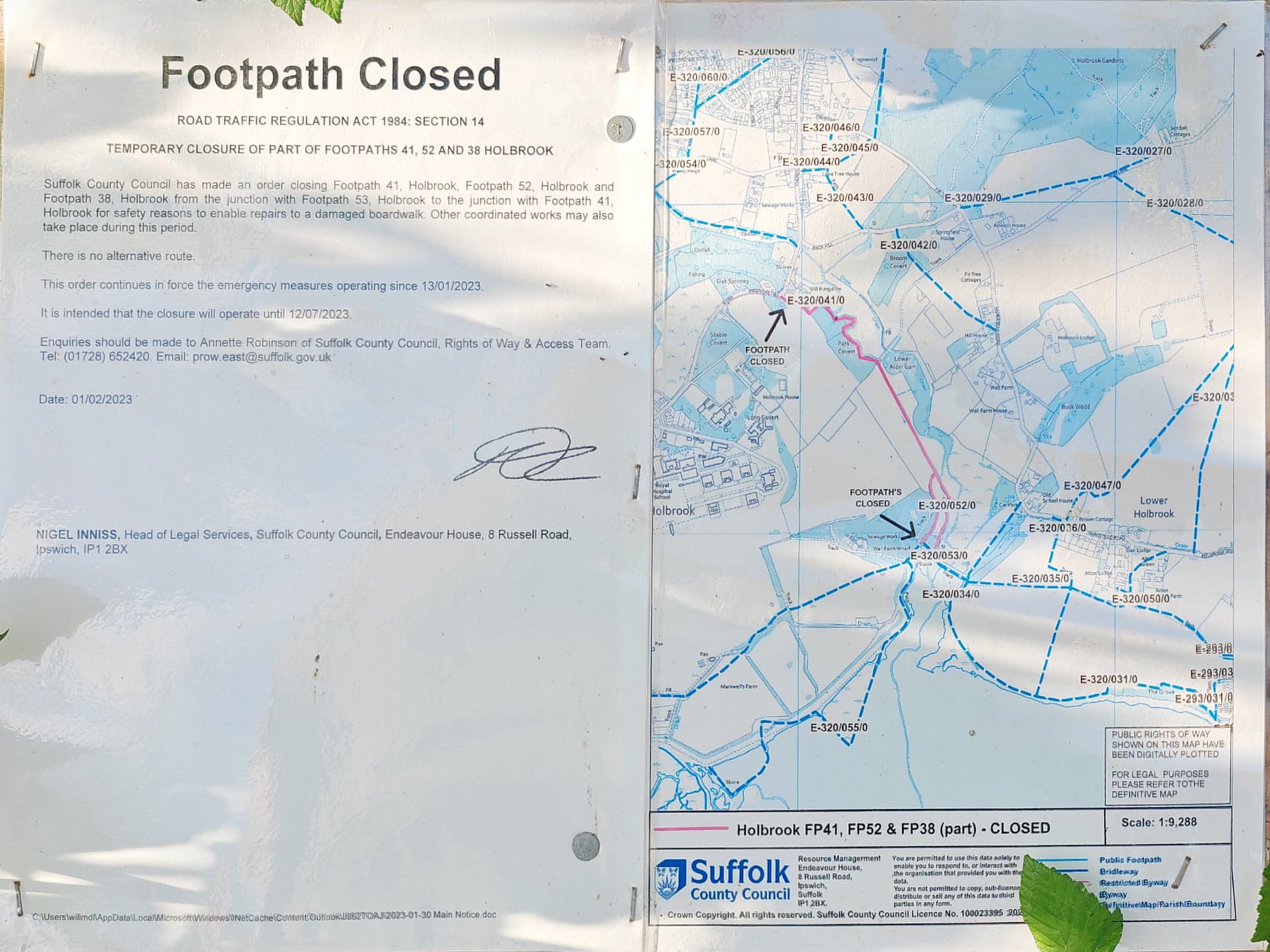
Route affected
Details of restrictions
Dates
FP41 and FP52 and part of FP38 Holbrook.
From 616930 235720 to 617390 234980 and 617430 234940. In the interests of public safety the footpath’s are closed due to a damaged boardwalk.
13 January 2023 to 12 January 2024
But agree with @SomeoneElse - this isn’t a short closure and if work hasn’t actually started, it’s quite possible the closure will be extended again. So access=no and (optionally) disused:highway=footway with a note=* explaining the closure.
Also worth noting that it appears the public footpath “FP 38 Holbrook” ends prematurely in OSM and actually continues north (along a farm track?) to meet “FP 52 Holbrook”.
That missing section is also part of this closure notice, so not a huge issue right now but would be worth surveying and mapping.
Where a closure is actually temporary for a particular period of time only it might make sense, but this case doesn’t sound like one of those. Looking at one of my examples again, the closure notice does have an end date on it, but that only describes the length of the notice, not the length of the closure. The length of the closure is indefinite until (in this case) some fairly major riverbank renovation work is done**. Likely the date will just get nudged on a year and I’ll update the note in OSM accordingly
What I tend to do personally is to check every now and again what the state on the ground is (see here for another example). If there’s an advertised end date I tend to add myself a reminder outside of OSM to check periodically.
** The Environment Agency are quite busy upstream, and the local drainage board have been active on several sections downstream but there’s been no activity that could resolve the closure before the currently advertised “closed until” date.
I must admit I haven’t seen, or ever used, conditional tagging this way. As far as I can see, this isn’t a documented usage. Instead the documentation focuses on “permanent” restrictions rather than temporary.
They do still suffer from an update problem though. As shown in this very example, the conditional tags would have needed to have been updated otherwise the path would have re-opened in OSM whilst still being closed in reality.
Perhaps it’s better to default to open but I could see this leading to greater frustration, i.e. if being routed there and finding the path is closed rather than simply not being provided a route at all.