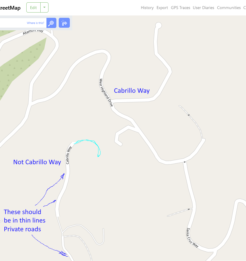
Cabrillo Way is on some official maps, I think based on some old plans and easements. The actual street doesn’t go where it is shown. The Open Map has now a connecting piece taken out (corrected) that was wrongly linking Cabrillo Way to West Highland Drive in the South. But the road is still shown wrongly. The Southern end is a private road not called Cabrillo Way. Cabrillo Way itself is not part of the Ventura Public Road list https://s29422.pcdn.co/wp-content/uploads/2019/05/RoadInventory_WebPage_March-2023.pdf But there is a hybrid public road designation in Ventura county that may apply. I.e. not maintained by the county but accepted as public road. The easements in the County Assayer’s map show the road going to places where there is no road in reality. The area is mountain spurs and ravines. The Assayer’s road path is impossible in the way the area has developed since those maps were drawn (1927?) At any rate, the road named Cabrillo Way ends at 280 West Highland Drive. Anything else is a private road without public road recognition. It should be marked with the thin lines for private roads and the extra road name for Cabrillo Way should be removed. Why it matters? Private roads can be blocked by owners. Public roads or recognized roads need to be kept open and without gates. Since your map is now used as basis for people to keep a watch on fire, roads need to be reliable. 60 mph wind = 1 mile a minute an ember can go. No time for false turns. I now managed to get a user name and log in (after 5 tries) But the “beginner’s guide” was already way over my head and didn’t address how to correct this. So, now what?
Nope it still isn’t correct. The Private road is shown as a second part of Cabrillo Way. That road name needs to be removed there and the width of the line corrected to match what is used for private roads. As I mentioned in my post all that was done was remove the connecting section. That’s why I got on here.
You can see from the screenshot, the way that section abruptly cuts off, that your web browser simply has an old copy of the map in its local cache.
If you’re on Windows, you can (usually) press Ctrl+F5 a few times to force a reload. Otherwise, you can clear your web browser’s cache. Suffice to say, the issue is in your web browser and the map on the server side is actually updated.