Yeah I encountered someone “fixing” a decades old abandoned jeep road where the part of it that met currently maintained trail is heavily washed out and then covered in bushes to the point that it doesn’t exist anymore.
My partner and I spent 5+ minutes wandering around looking for it, couldn’t find it, then just XCed over to where it said it would be a bit further down. Couldn’t even follow it all the way back when returning! I figured I’d be saving the next person time, but heaven forbid some lines don’t connect and a routing application can’t tell you stats for a dead end abandoned for decades road.
I suppose in that sense the anti ground-truth nature of trail_visibility=horrible (and to an extent trail_visibility=bad) is viewed as a feature rather than a bug.
Well they could still get routed over those scrambles even though they wouldn’t see the path before being routed. Adds even more excitement and mystery!
Joking aside I get the importance of routing in urban environments, but if I’m two-three days from a road and a day from any trail I don’t care at all about someone’s made up line. Modern routers make it very easy to skip from snap to trail to manual lines for XC and then back to snap again. Drawing fictional permanent lines to speed up that process (knowing that the data won’t be accurate anyways) that then get rendered as actual (faint) trails on maps that will lead people astray seems like it’s not worth it.
Heck even with accurate ways of an actual trail depending on what algo you use to parse out the elevation profile there can be significant changes (5-15% iirc?) and drawing straight lines will always underestimate actual off trail mileage which is a risk in and of itself if accurate routing is so important. There are times when I’m literally bouncing from one end of a cirque to the other like a ping pong ball to get a safer downclimb on a steep granite fin with snowmelt running down it, knowing the distance of a straight line down at this point is just kind of rude.
Ah, the very intuitive highway=path. The Pacific Crest Trail is jokingly referred to as a highway at least.
Are standards relaxed for routes that are in between trails?
Is the actual path taken down the screefield an official route published by a reputable authority, or can anyone familiar with the area choose what line to take because it’s in between two pieces of trail?
I’ve seen trails on OSM posted by locals familiar with the area in Canadian Rockies that are basically personal GPX tracks off peaks, with everything above treeline tagged as alpine_hiking including simple single track trails. I’ve also come across a lot of people very familiar with the Sierra Nevada giving very bad beta about off-trail routes.
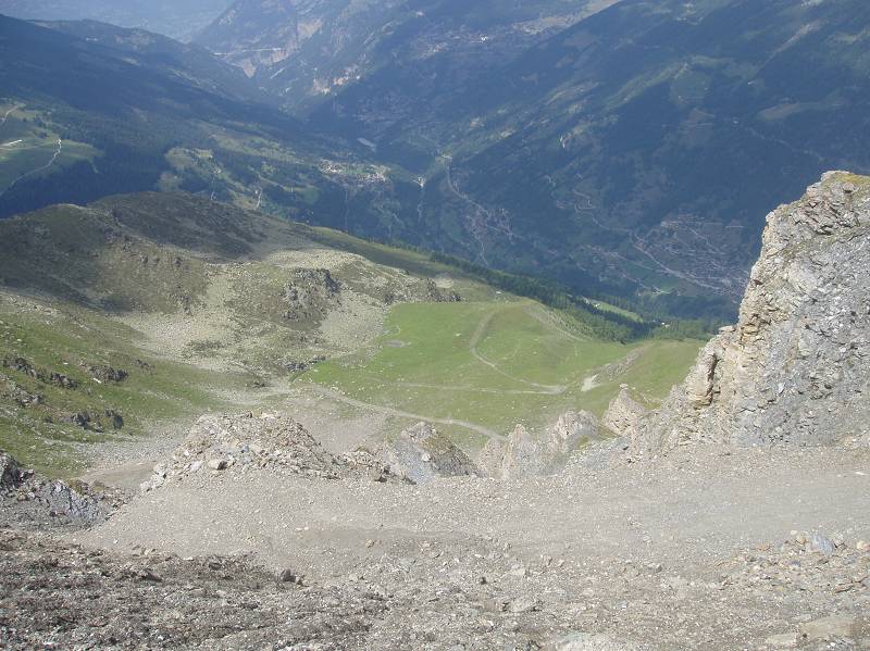
If I came across this scree field and kept seeing a path on my map I would wonder:
Did there used to be a trail here?
Is there a trail here but I missed it?
Did there used to be a trail, but there’s been enough slides that it’s gone and the terrain is now unstable?
If it was clear that this section was intended to be a route I would just analyze the terrain, vs having it obscured as being part of a larger trail_visibility=horrible path. I also don’t really care what a stranger on the internet thinks is the best line for me to take. Maybe they normally do the trail from the opposite direction, maybe they prioritize being at a lower angle but having looser terrain, or going more directly or more indirectly, etc. If I am tricked into thinking there should be a trail there, I’m tempted to try and follow it out of curiousity to see where it goes, if it comes up later, etc and it’s really just a distraction.
If we are going to hold routes in-and-of-themselves to strict standards, we shouldn’t let a random person draw them in between stretches of trail. At least going with a node based approach leaves a lot of wiggle room for people and puts them into the mindset of routefinding. If someone needs to stare at their phone while going down a scree field they probably aren’t ready to go down a scree field.
Yes, I think that’s an important point. Some but not all hiking apps let you plan a route over pathless terrain and calculate stats etc. Here’s an example from Komoot. Of course the stats are a bit wrong compared with the actual route you’re going to take, but the UI makes it clear which bits aren’t paths, so the user gets a chance to realise, and decide if they really want to hike it.
If you’re planning a trip like this and your router doesn’t let you do this, you’re probably using the wrong app. It’s not a reason to add paths to OSM data that don’t really exist…
(Personally I don’t mind short exceptions, especially in areas that aren’t dangerous, like in the example above where you can draw an approximate line on the beach from the Strava heatmap. I’m just talking about miles and miles of “paths” in difficult mountain terrain.)
(not sure I’ve seen the definition but) I guess everything’s routable in some circumstances - the question is whether it should be offered as a choice to someone “just walking from A to B” as opposed to (say) climbing a mountain.
And those stats are already going to be wrong with an illusory line to begin with. Perhaps they would be slightly less wrong, but the vast majority of the time a significant amount of extra time and effort is required on pathless terrain. It amuses me when a PCT thru-hiker asks about a pathless route like the SHR and expects to do 20 miles a day over rough terrain in their trail runners.
I’ll often use similar swaps between swap and manual in Gaia or Caltopo to plan out long trips that are mostly on trail but have stretches of off-trail if I’m not familiar with the area and concerned about trip length and elevation (more the latter, flat trail goes fast even with a full pack).
Exactly.
I feel like mountaineering (or mountaineering-lite) should have some level of optin or friction to it. I literally had someone last year make a loop that included an abandoned trail with large gaps in it where it drops fairly steeply down fairly large talus (blocks) for ~1300ft. The trail also comes and goes below Lake Italy, and has some slow sections requiring routefinding, uncleared deadfall etc. For someone used to hiking off-trail it’s fairly standard terrain, but for a trailed hiker it could be a different story.
Technically that is a trail_visibility=bad trail, so people should expect gaps in it but not all map clients expose that granular information, and even if the tag is there you need to read the wiki to understand that means that the trail sometimes doesn’t exist vs isn’t just hard to see (which I think would be the intuitive understanding of that value).
Someone days ago asked about conditions of the trail over Hopkins Pass - large parts of it are pathless T3 / Class 2 hiking over moderately steep scree and talus with some no fall zones, but it shows up as a trail on their map. I can’t blame them for assuming it’s a trail.
One simple way around this would be to request routers not to auto snap / route on trails that are visibility of horrible or no (and bad?) unless the particular trail segment is selected as part of the process. Ideally there would be some kind of “opt-in” where someone could manually toggle routing on if they were comfortable with it but that’d be a bonus.
That said I feel it’s important information to know where a trail doesn’t exist anymore. If 70% of it going down scree/talus exists, and 30% doesn’t, it raises some meaningful questions about that 30% and why it isn’t there anymore! If it merely fades out crossing a meadow that grows faster than the amount of boots on it tramp things down (Center Basin where it gets a bit marshy, Tamarack Lakes Trail at one point) it’s trivial. People can double check with high resolution satellite imagery, but that feels like a bit of a burden to ask everyone to make sure a trail actually exists.
Difficult terrain does not just exist in the mountains!
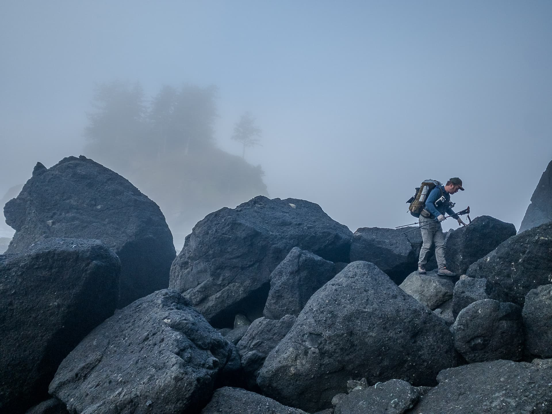
The canyons of the desert southwest can easily get into technical climbing. The keyhole route in Canyonlands gets into fatally exposed Class 2/3 (T3-4). But lets go back to the “beach” in question.
We consider ourselves experienced hikers (but not experienced beach hikers) Please do your research and be well prepared if you decide to do this hike! The southern most rope assist before Seafield was pretty much a 50-60 foot rappel, since it was so steep with no good foot/hand holds. Hubby and I got stuck on a small pocket beach (kinda nice there actually) waiting for tide to go down. Saw a woman and her son stuck standing on a very small dry patch nearby for 2 hours (not very fun I imagine). I almost cried when we finally got to the beach on the other side. Multiple scrapes, bruises, twisted knee, and broken toe from struggling with a heavy pack on the huge rocks as surf spray added insult to injury. Later, a few locals told us stories about rescuing people from this area frequently. Since I was definitely NOT going to return that way, we cut our losses and grabbed a shuttle from the Lake Ozette Ranger station back to our car. Best $150 ever spent!
Summary: This section of hike south of Point of Arches is too dangerous to be enjoyable. You are so busy watching foot/hand placement and outrunning the tides that you never really get to see/enjoy the amazing views until you hit Seafield.
Musts: pack as light and tight as possible, use the right map with clear tide level crossings, gloves, knee pads, and a sense of humor.
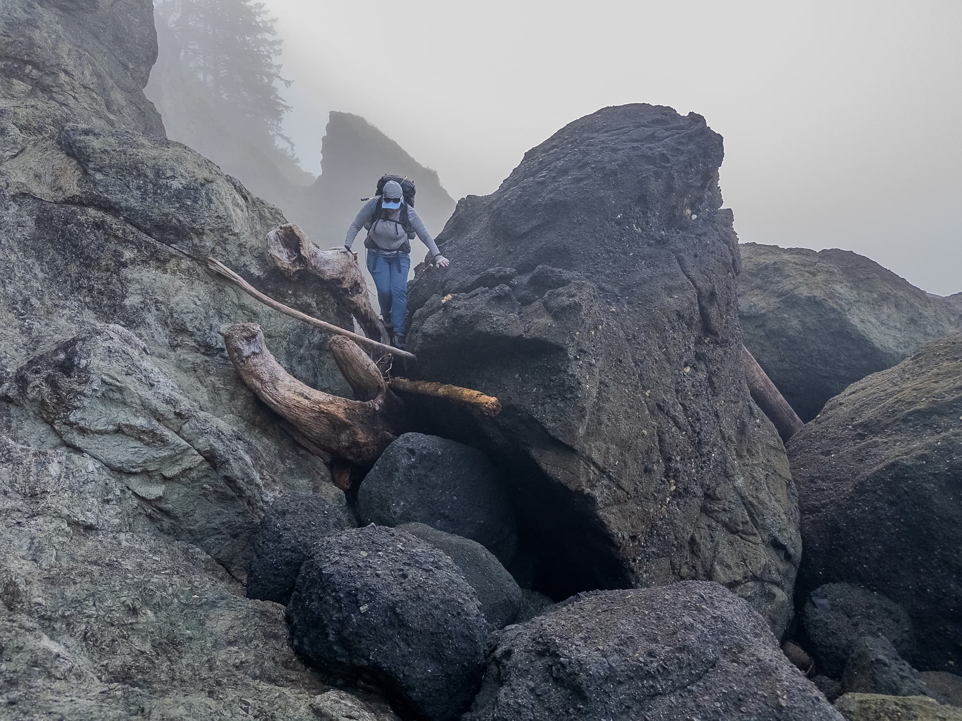
My partner and I both enjoyed the routefinding of this section, but we’re very comfortable moving on talus. We NEVER rapped 50-60 feet as the ropes are informally placed sea scavenge, though there were two places where it was impossible not to load them for around 10 feet or so. I either had a different rope in each hand or tried to firmly plant a trekking pole with a free hand if that wasn’t an option. Did not have knee pads and did no cry and came out uninjured. We actually did it twice lol, started at Rialto (bottom) went up a bit past Shi Shi (top) and then dropped back down to exist Ozette to save a lot of shuttle vehicle driving + expensive private parking fees (and that section seemed the most interesting).
What made it spicier is that there was only a window of a few hours to get through it until the tide came in, a disabling but non-fatal fall could end up fatal later.
Definitely alpine_hiking, or more intuitively hands_for_assistance
In terms of the miles on end bit, the section between Norweigan Memorial & Yellow Banks is called Purgatory because it’s a little over 4 miles of constant T2 / surefooted Class 1 terrain. I budgeted a lot of time due to it’s reputation, about halfway through my partner asked when we were going to get there. Counting a lunch break it took us a bit over 3 hours iirc.
This leg was rough and slow going for the first 4ish miles, as you navigate slippery rocks, wet rocks, slimy rocks, barnacle rocks, small rocks, large rocks, seaweed-covered rocks, algae-covered rocks, and large-puddles-disguised-as-seaweed-patches. We all slipped several times and wound up with some scrapes and bruises. Trekking poles and good-traction shoes are an absolute must. There was also no water for the first few miles of this segment.
When we emerged onto glorious hard-packed sand beach for the second half of this leg, it felt like a miracle like no other feeling in the world. Some really beautiful sea stacks in this segment.
I joked that if you like Class 2, then it’s Type 1 fun… if you are expecting Class1 it’s Type 2 fun.
IMHO this route would be useful to have occasional nodes with metadat marking shifts in difficulty and terrain. Unfortunately surface only allows one value, which makes it useless in a lot of places where depending on tide you can have 4 different types of surfaces available that are noticeably different to move on.
I have no problem with routes having gaps or areas as members. Software can in principle and in practice handle that, it’s about time they all implemented it. However, since currently most routes are expected to be linear (though some have variants, and some are more like collections), and QA-tools and validators are using that assumption, I would prefer routes which are intentionally gappy, to be clearly recognizable as such.
I remember a discussion about routes having fixed points, but in between you had to find your own way trying to avoid or conquer the obstacles and hazards. Renderings or routers could find and show an approximate route, an educated guess, based on terrain attributes and objects in between.
Basically, the gap is two nodes without a way in between. You can’t add a tag to a gap (I tried, but…), so solutions tend to come up with fake ways. In a well ordered route relation tagged as having gaps on purpose, fake ways are not necessary, I think.
Basically just rendering nodes as items in a route, and/or as a simple thing-that-can-be-done-now solution render the points that make up a way but not visually connecting them (though there’d need to be some way of denoting they were part of X or Y relation etc) for visibility no and perhaps horrible.
I don’t think the gap needs to be tagged, the nodes themselves can indicate what is going on whether that’s the current (semi-useful) surface/smoothness/sac_scale or something more descriptive ala “head up to white X of boulders then traverse”. The gap is then the just the space between nodes.
Being able to include walkable areas is potentially very useful (this overland trail goes to this beach / intertidal zone), and limits the need to have nodes arc across a beach to keep routing guesses reasonable.
This sounds… potentially terrible.
It’s fine for trying to come up with estimate for mileage and elevation etc, but if software draws a line between nodes (based on a LLM model that looks at satellite imagery + high resolution slope angle data?) on a map, people will try to follow that line. It’s just how they work. There will be consequences.
I don’t think the issue is how to come up with more fake lines.
Depending on how accurate the software is, this could easily be worse than just letting anyone “familiar with the area” draw up the master route, or having other people put in any number of alternate routes until the map looks like a spiderweb.
This thread is the spiritual successor, coming at it more from a functional angle than an abstract one.
It is not mentioned there, but practice shows, scrambling or non-technical climbing is a kind of travel, some even consider technical climbing a mode of travel.
PS: Anecdotally, the Brits had quite some influence in finding routes up the mountain peaks in the area of my local knowledge – they were quite against use of hands; does not suit a Gentleman to walk on four legs. But these times long past
To a certain extent OSM just isn’t suited as the sole source for proper backcountry, and I think that’s fine.
What I do think should be clearer is when people need to do their own homework. I’m comfortable going XC, and if I see a lighlty stippled line I’m assuming that it is either a social trail or an abandoned trail and adjust my expectations.
Again people see a line and assume it’s a trail. I’m definitely guilty of just going on trail without doing any research as I’m not really worried about a trail. One time that led me to a 30m+ vertical rappel down a dryfall, I laughed and ignored the line and did my own routefinding (then deleted it later).
It seems like there is a general consensus emerging that some node or node looking way is a good way to approach this.
Rear axle finally arrived for my vehicle and got installed , we’re mostly over COVID, and we have a wilderness permit booked for tomorrow so I’ll be AFK for a while. If someone wants to carry on how to best do nodes in a route, what would be appropriate for them, etc that’d be great and I’ll check in later.
I just returned from a DIY Sierra high route. What I found the most helpful in terms of balancing visibility of known alpine trailless routes, ecological impact, and recreationist expectations (preparation, skills, etc.) was the labeling of passable saddles with no specific route indicated.
Reminds me a bit of a mapping of mine years ago: I just mapped short unconnected paths along a stream where the easy way around a scarp/steep step/waterfall. Certainly, cannot surpass a node in parsimony
PS: Of course this triggers QA warnings - because the goal of openstreetmap is to produce a gapless routing graph? Honestly, I never seen the proposal.
Agree. OSM aims to provide map data, to be a hiking guide would be a serious extension of that aim.
I don’t think it’s an OSM responsibility to teach people how to use a map; map users should indeed do their homework and read the legend provided by the map renderer. It is the responsibility of the renderer to make it clear in their legend that a dotted line doesn’t always mean that there is a path.
The big advantage to map a route suggestion as a way (an ordered list of nodes) is that it will be easy for routing apps to calculate ascent/descent, distance and time (approximately) of a route. If we map a route suggestion with nodes only, such app needs to find out the order of the nodes by itself, which seems more difficult to me (I’m not an IT expert though).
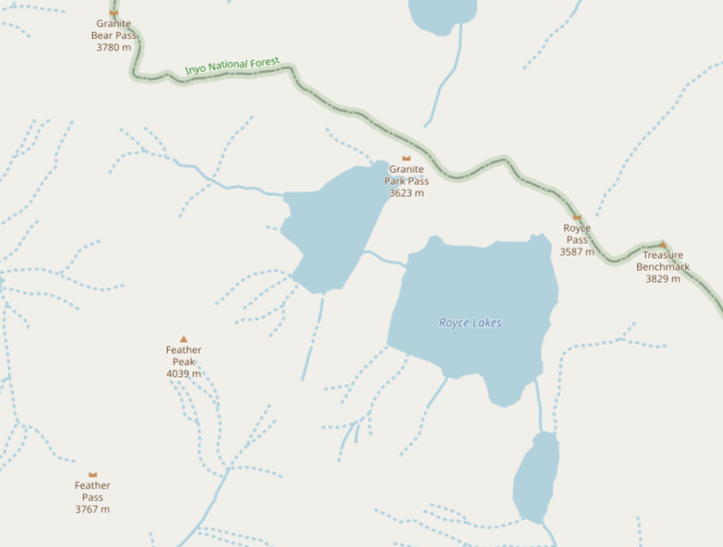
Hello from the slack channel. That’s a nice area, I actually put in the Ursula pass entry for it (don’t use that one though) and @oddlyangled and I have been working on the xc passes in the Sierra (him more than I). Bear Lakes basin is getting a little ridiculous as basically every low point along it is a named pass now, and of the 11 ringing the basin some are a lot nicer than others. OSM is missing featherlite, which is actually one of the more reasonable ones.
I got out of a trip just south of there: 2024-07-25 to 2024-08-02 Bishop > Knapsack > Potluck > Cirque > Mather > Cartridge > Vennacher Col > Taboose Passes, with a lot of basin wandering dayhikes in between.
TBH for many years I’d just head out with old USGS maps + slope angle shading and went over a lot of named passes without knowing they had names. Heck two summers ago I went over Adventurer and Observation Peak Pass blind (they weren’t on OSM then, I had chatted with a ranger that went up it in 17 and knew it went and figured I’d be able to handle it) and found out all the existing beta for the former was terrible a few weeks ago.
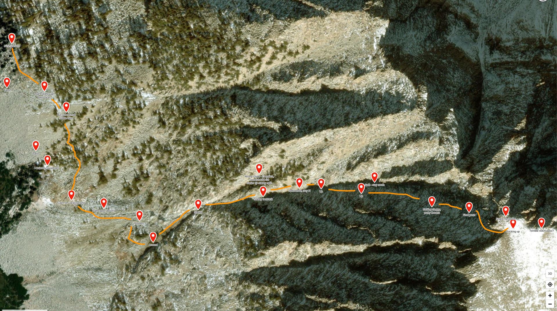
There are some passes where just knowing the top isn’t really enough, or for which the bottom is just as important, though this is the minority for the range. The best example is Little Joe - which avalanche chute to start from is just as ambiguous as where the top is. If you’re heading up from Lake Reflection it wouldn’t be obvious unless you were looking at high resolution satellite imagery on the ground. North Col is an example near where you were of a section of ridge with a fairly wide CYOA exit point (it really should be a line vs a single node) and is nowhere near the lowest point, but is part of a “route” in a guidebook and is therefore a natural feature “saddle”.
update: added in featherlite.
Or provide recommendations for them not to connect the dots. They can obviously do what they want.
I do think for official routes there is also some value in having a relation of nodes where you can have metadata for the nodes showing changes - say when a route shifts from T1 to T4 etc.
To clarify a bit on my earlier response - I agree in most cases this is enough. iirc Italy Pass, Dancing bear, Feather (the only hard routefinding was the chute into La Salle, I think we botched it lol), Ursula, and Royce pass I did with just topo and sometimes Secor (before two of those were on OSM and I didn’t know what Royce was). Featherlite, Brown, Granite Park, and Granite Bear passes are also doable without any beta or instructions, as they are straightforward and you can see the entire pass.
These are also not official “routes” - but they are useful to think of how many waypoints a route really needs! Most of these could literally be just a top and bottom dot (where bottom dots are relevant) as they are short and straightforward. If there was an existing detailed way and renderers just disconnected the lines between the dots there could be many dozens of dots close enough together it essentially forms a line vs leaving the more CYOA sections wide open. My example of Valor Pass was trying to find a happy medium between it feeling “guided” while not being overly prescriptive.
Skurka’s KHCBR tries to put dots every half mile or so in order to keep things vague, but I see people taking the wrong shore around 10565 and having to crawl under vehicle sized talus with packs, or just dropping straight down adventurer pass into unstable talus vs bypassing it just to the north on safe terrain etc. Someone with good routefinding (not a blogger that found their first mylar balloon in the backcountry) would be able to make those decisions, but IMO part of something being a “route” is that it is somewhat guided - if it isn’t people can easily get in over their heads expecting it to be ok vs treating it as being off-trail with respect. Obviously everything shouldn’t be spelled out, but areas where there is genuine danger or at least large discomfort should probably be noted or routed around. It was fine for me doing that section blind with topo and slope angle - I had talked to a ranger that mentioned going up the drainage in 17 and it was ok so I felt it’d be more enjoyable to wing it, but I’m experienced at routefinding.
Unlike the Bear Lakes Basin passes mentioned, some passes do have a bottom point that isn’t clear at all, and is as or more important than the top point. Little Joe’s has one top and one bottom from a bunch of different avalanche chutes that are Class 2 / T3, everything else leads into exposed Class 3-4 / T4-T6 terrain. The top of this is not a natural saddle in any meaningful way, so that’s already a hack. People can CYOA up from Lake Reflection, but in this case I think mapping the bottom point of the actual chute is a good idea - it’s not intuitive and people do get off-route on it pretty regularly. Anything more should probably be a custom map layer import or something.
In terms of official long distance routes, I don’t think just having a node at the beginning and start would make sense. I suppose in the north coast route case in Olympic national park the terrain is constrained enough, but people have pointed out how routers would draw straight lines across the ocean in bays etc. Having some occasional nodes to mark shifts in terrain difficulty along the route would make sense to me, even if intertidal zones are marked as walkable for the router to go through.
In the end how detailed routes are will probably just be up to regional norms - OSM can describe the structure and how to render it, but different places will keep them more detailed or more vague.
Mapping unofficial trailless routes in OSM, like Skurkas, contribute to environmental damage and SAR incidents. If you don’t have enough backcountry knowledge to pick the safest/least environmentally impactful way around a lake, you shouldn’t be doing a high route. Those routes aren’t appropriate for people who blindly follow a GPS track.
Well, following a GPS track, people always are in the know: They trace the ramblings of the person that published the track.
While following an openstreetmap track, they get the promise of a path. How many of those are aware, that an Openstreetmap path can mean a lot or nothing?