Hi,
Not answering your question, but to make it clear to other readers is that OSM maintains chronology for all objects from the moment they are created. The unfortunate part is, if e.g. a road is split for reasons of say different restrictions for a section, the chronology is by default inherited by the segment with the most nodes, albeit, certainly in my editor of choice you get to choose which part has to get that history.
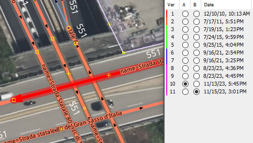
Avoiding showing mapper id’s the right hand side of this window shows who done it, when, what tags were changed/added, deleted.
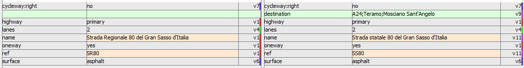
(not sure how v1 to v11 are identical for the second last tag and happened on the last, 11th edit)
There area mappers who’re seemingly agnostic about the want of OSM, a many mappers ethos, to do all to retain the chronology, and seem to prefer deleting things and remapping, turning objects into V1 again, Certainly in the JOSM editor there’s no need. Redo an object which is often much quicker than the arduously dragging nodes around, adding more, just select to object to be replaced with new and hit Shft+Ctrl+G to transfer all the tagging and history. Does of course not work when splitting ways. Only one part gets the history.
Disastrous it becomes when a certain ‘easy’ apps is used for on-the-road surveying. Update a crossing, add all the details and each detail is added in a separate change set, ending you up with V5,V6, V7. Do a road, add paving, if it’s lit, how many lanes, if oneway… all adding a version and timestamp each. At least another on-the-road concatenates the changes into a single edit and makes a description of all the tags that were updated for the object.
(thread hijack in the air, the moderatore may split this off as OT, a serious versioning bloathing to me).