Hello everyone, I am looking for a way to generate a map of all railways in a country, with different coloring based on whether they are electrified, proposed to be electrified, or not electrified. I would like to be able to make a slippy map, i.e., be able to zoom in, and see other things that are on normal maps. Basically it would be the same as openstreetmap.org but with a slight change to the standard OSM Carto style. But I have no idea how to get started. Any ideas?
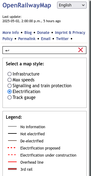
Are you aware that https://openrailwaymap.org/ supports this already? There is an “Electrification” map style:
Why not promote the more modern fork instead
https://openrailwaymap.fly.dev/#view=1/0/0
Uses OHM for historical railways so people no longer need to map dismantled railways in OSM
1 Like
I didn’t intend to disparage the fork, it was more a matter of me only having a faint idea about it and not remembering the URL. ORM said its data was up to date so I didn’t think it was dead.
That’s great but it has nothing to do with existing or proposed electrification as the OP asked
1 Like
Thank you, I did not know about that and that is perfect. What was the point about the data being out of date? How can I check that? And I explicitly do not want historical railways but rather only active ones that I can ride on today.
Some forum threads are indicating that OpenRailwayMap does not actually fully update when OSM is updated, even though its “Last update” time in the sidebar indicates it did. I don’t know the details, I know basically as much as I found searching this forum for “OpenRailwayMap”. It seems unlikely to be an issue right now unless you’re looking at newly constructed or electrified railways.
On a wider point, OpenRailwayMap appears to generally be abandoned or at least rarely updated, and while it keeps on running now, general belief on the forum seems to be that the newer map https://openrailwaymap.fly.dev/ linked by @Le_Sharkoïste1 is better (or at least currently more maintained). The old one has an easier-to-remember URL though…
https://openrailwaymap.fly.dev/ doesn’t show the historical railways by default (you would have to use the selector in top right of the screen which defaults to “present”), so that should be good anyway.
1 Like