I’ve spent significant time in Cambridge earlier in my life, it I’d put that as an obvious place=suburb. It’s effectively part of Boston, is on the subway lines and lacks an independent urban core.
If tomorrow, Boston annexed Cambridge, we wouldn’t even be having this discussion – we’d all agree that Cambridge is just a neighborhood in Boston that used to be its own municipality.
Interesting! I think this sort of tagging could make sense, but it’d be a pretty radical change in mapping practice to map independent incorporated areas as place=suburb. As far as I can tell, in the US that tag is only used to map regions within incorporated cities, essentially large neighborhoods. Is there anywhere in the world that maps places outside of the main city’s municipal boundaries as place=suburb? I guess this is the logical endpoint of divorcing the admin_level/municipal classification of a place from its place=* value though!
I think this is still up in the air. If we’re tracking my idea to base classification on Urban Areas, we’ve only gotten as far as possibly determining whether the UA should have a place=city in it, which would obviously be true for the Boston UA. But we’re less clear on how many places within the UA get that distinction, and which ones besides the primary place named in the title.
If we set a budget for the number of city based on how many times over the UA exceeds the 100,000 threshold, then there would certainly be room for Cambridge. Why is it that Cambridge doesn’t appear in the UA’s title? Apparently if fails both tests for inclusion as a secondary name: it has only 54,000 housing units, less than two-thirds of Boston’s 302,000. After all, the carveout for secondary names is intended for close ties, not also-rans.
I don’t have as much local knowledge as you, but my impression is that it might be possible to relegate Cambridge to the same classification as more obscure places within the same UA. At the scales that Cambridge becomes especially relevant as a city, a data consumer is less likely to make distinctions between city and town or even use place=* points at all. These are scales were place=suburb starts to become relevant.
If this poses a problem, maybe we could consider its primary position in the Cambridge–Newton–Framingham metropolitan division. I’m just wary of bringing in anything from the CBSA hierarchy, because it’s based on administrative area populations that include rural populations. That problem doesn’t show up in this case, because Cambridge is in the middle of such a “thickly settled” area, as those lovely MassDOT signs say.
I’m not sure that I really thought about suburbs, but there’s certainly a string of suburbs between Fall River and surrounding cities (mainly Providence and New Bedford). If your urban core is big enough, suburbs just naturally follow as population decays outward. The suburb test is more viable in the most built-up regions and I’m not sure it’s a good test as a general rule otherwise.
In the context of Maine, Portsmouth is significant, but in the context of New England and the greater Boston area, I have to concede that it’s approximately a Newport, RI in scale. I excluded Newport from my lists because it’s overshadowed by Fall River and Providence, which are of a larger scale to the point where Newport is clearly in a lower tier.
I included Bangor on the basis of name recognition and I have to admit I’ve never actually pulled off the highway to visit the place. My logic in including it is probably giving it a rural bonus, in the same way I’d include Fairbanks or Nome based on relative importance. I could be persuaded either way.
I’ve been avoiding and somewhat dreading this question. In general, we probably shouldn’t apply place=suburb to the American definition of “suburb”, because globally this tag is meant for inner-city city divisions, such as La Défense in Paris. Even most inner suburbs in the U.S. couldn’t be characterized as inner-city. But the calculus may be different in New England, where municipal boundaries don’t even attempt to approximate settlement patterns.
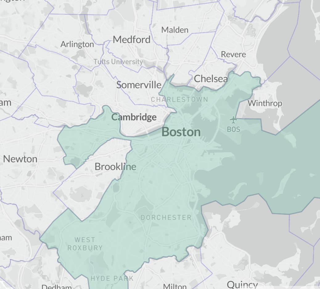
The sense I get is that the usage of place=suburb only for named places within the boundary of a larger incorporated city originates from regions where city boundaries are expanded in a logical manner as urban areas grow. In some US metro areas this happens, but others annex areas in a more haphazard fashion. Here you can see how Boston has annexed a number of towns to the south but not so many to the north. To the west, Brighton has been annexed despite its tenuous connection, while Brookline, Cambridge, and Somerville remain independent. To me it seems odd to say that these three can’t be place=suburb because they are independently governed. Functionally I think they are just as much of suburbs as Brighton is.
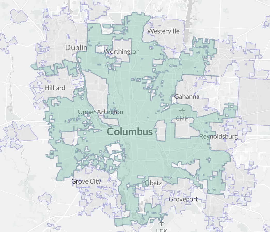
Some cities like Columbus, OH have even expanded fully around small municipalities that remain independent. I can’t imagine that locals really consider the enclaves significantly more distinct from the the main city than other annexed towns right nearby.
Basically I’m in favor of being a bit flexible with the usage of place=suburb and allowing it to be used for cases where it would seem sensible for a municipality to be annexed to the larger city but for whatever reason that hasn’t happened.
Oh interesting it appears that La Défense is technically outside of the Paris admin boundary (edit: or is it this one, or this one). Maybe the European and North American concept of “suburb” is not as different as we’ve been thinking. Or maybe I’ve misunderstood something here.
Depending on size, some enclaves could be good candidates for suburb and others might not be. In states like Ohio, cities have historically had considerable leeway to annex surrounding territory, often by coercion, even at times by fiat without the consent of its inhabitants. In Columbus, many of the city’s outlying “tentacles” and even some of the well-connected parts have a classically suburban character. In other words, in a European model, these areas would be considered to be on the outskirts or beyond, even within the city limits. But it’s difficult to compare a sprawling American city to older European cities.
Maybe I chose a bad example. It was just the first example of a European new city center that popped into my head.
Distinguishing between inner cities and inner suburbs is complex and requires us to consider history and socioeconomics. It isn’t something you can necessarily draw up rules about. That’s why I was hoping to skirt the issue for a while.
Yes, this gets to the heart of it. Ignoring our American English ideas of what a “suburb” is, essentially I see the argument that Cambridge should be place=suburb is that its role in the Boston area is similar to Brighton, or other suburbs like South Boston or Back Bay: major regions within the urbanized area.
I think this is a reasonable argument from an urban planning perspective! Certainly, as Brian put it above, if Boston annexed Cambridge tomorrow we wouldn’t be having the discussion. But I’m not sure it conforms to the prevailing definitions of the place= tags, or maybe more importantly, what any user/consumer is expecting. Would an area map of Boston or Massachusetts really show Cambridge, South Boston, Quincy, and Roxbury the same way? Maybe it would, but I kind of doubt it? At some point, I think the fact that it’s its own incorporated place might make a difference in people’s conception of the place, and so it might be a difference worth preserving in tagging.
It depends entirely on what the map is depicting. If it’s focused on place-names, then yes. If it’s focused on administrative boundaries, you’d get something different.
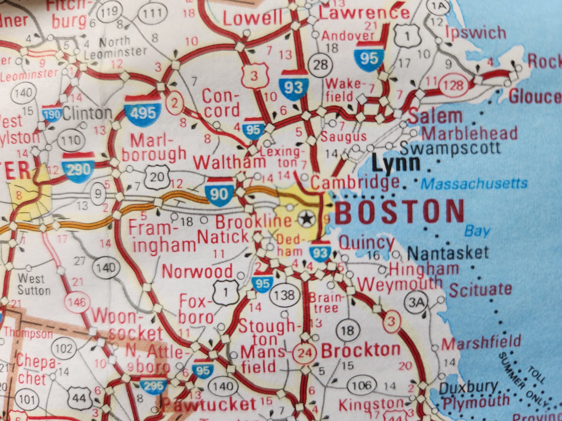
I submit as evidence this clip from my box-o maps 2011 AAA map of “Northeastern States and Provinces”
This actually looks pretty similar to how US cities are currently tagged! Not to say this has to be correct, but idiosyncratic city boundaries are certainly not unique to the US. If you value your sanity, don’t look at how places in England, like around central London, are tagged
Wait a sec, which one is this supposed to be evidence of? This seems focused on place-names, but looks like it only renders independent municipalities as places: Cambridge, Quincy, and Brookline get dots and labels, but ostensibly equivalent suburbs that are part of Boston proper, like Roxbury, Brighton, Back Bay, and South Boston, are not shown. Cambridge, Quincy, Lynn, and other bigger places also get bigger labels than smaller towns like Lexington and Saugus, although not as big as Boston or Worcester. The line between ‘medium’ and ‘small’ seems to be at a slightly lower population than prevailing city/town tagging though, since places like Waltham and Hingham make the cut for intermediate font even though they’re tagged as place=town in OSM, same as Lexington and Saugus.
I guess this doesn’t clarify to me that place=town or suburb is clearly a better tag than city for somewhere like Cambridge or Lynn? In fact, it seems to support them at least staying on the city/town/etc. hierarchy, and that at some point there are more possible gradations than current OSM tagging permits.
That’s a good point. This is of course going to depend on the the map, but I’ve seen a number of Massachusetts maps that display labels for Somerville, Cambridge, and Brookline (all independent municipalities) while not showing labels for Brighton, Roxybury, or Dorchester (annexed to Boston).
Anyway, right now deciding exactly what qualifies as place=suburb is probably less important than deciding what qualifies as place=city. Once we have consensus on that, the lower classes should become clearer.
Right, whether we want to make Cambridge =town or suburb, I wouldn’t care all that much – but I’d argue strongly against it being an =city as that area is covered by the place=city + name=Bostonnode, which is conceptually completely separate from the type=boundary + boundary=administrative + admin_level=8 + border_type=cityrelation.
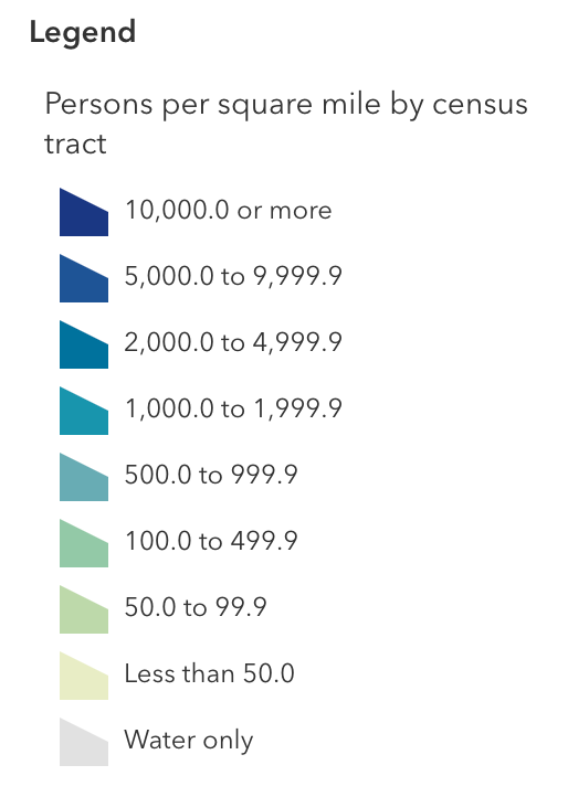
I’m finding this popuation density map from the census quite helpful for identifying potential place=citys. I’ve circled in red the densest urban cores that look like candidates to me. In a general sense, I think of the big circle in the middle as Boston and I think this shows quite well how Cambridge is a central part of this dense urban core (i.e. part of the same place=city as Boston). On the other hand, Lowell and Brockton are distinct clusters of high density separated from the Boston cluster by some lower density space.
This is Google Maps in a trenchcoat, and I’m glad you bring it up. In its heydey before things got weird, Google Maps pioneered the practice of clearing a “donut” around a major city, improving legibility. While I don’t favor baking specific presentational choices into the database, I appreciate that the urban areas force us to consider a similar “sphere of influence” around an urban core.
By some measures, it’s totally unfair for us to subordinate giant places to even gianter places while cutting punier, more distant places some slack. But the settlement-related place=* values become more useful when they can communicate something about the relationships between places. Some maps will use this classification scheme to establish better information hierarchy, while others will eschew it in favor of a scale based on population alone, in order to simplify the legend and make labels more predictable. Both approaches are valid in the hands of a map designer, as long as the population figures are based on something realistic like UAs.
Thanks for pointing to this! On OSMUS Slack, I found this approach analogous to finding the topographic prominence of a mountain. I think an approach like this is a pretty sensible answer to my earlier question:
To put it into words, if density declines significantly in between two places of sufficiently high density (so that each has high “prominence”), then both might be place=city. But if two places are part of one continuously high density/“thickly settled” area, and one is much larger than the other, only the bigger one should be place=city, while the smaller, low “prominence” place gets demoted. In this example, such an approach would allow places like Lynn and Lowell to remain place=city, while leading to the demotion of places like Newton and Cambridge, which are not sufficiently distinct from Boston despite their large municipal populations, to place=town. I find this result fairly reasonable! And it provides a nice check/elaboration on the census Urban Areas, which I think are a good starting point am wary about implementing with no flexibility.
I’ll add here that I think a little more nuance will be needed in the largest/densest areas, where significantly high densities persist across an entire 50+ mile region. But there are realistically only a few cities in the US sufficiently large for this to be a problem, and they aren’t in New England, so it’s off topic here. I’ve appreciated the discussion here!
I would personally draw the Boston conurbation wider, from Hull to Beverly, and west all the way to Route 128. I don’t think there’s a significant enough break in density up to Lynn or down to Quincy to really separate them from Boston’s influence. Heck, Quincy is even on Boston’s subway lines and isn’t even the last stop.