Syed_N
December 15, 2023, 7:09am
1
안녕하세요. 톰톰을 대표하는 Syed입니다… 이 기계 번역 메시지에 오류가 있다면 사과드립니다.
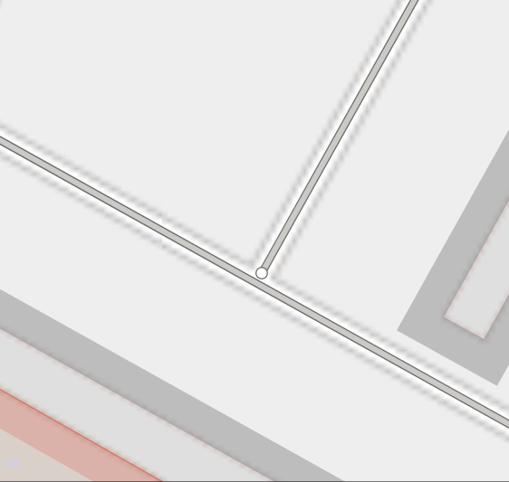
먼저 FOSS4G 아시아 2023 기간 동안 서울에서 열린 매핑 파티에 참여해 주신 분들께 감사드립니다. 다양한 국가의 커뮤니티 회원들이 모여 오픈스트리트맵 주제와 매핑 기술에 대해 토론하며 많은 것을 배울 수 있는 시간이었습니다.https://maproulette.org/browse/challenges/42476
예시:
관심이 있으시다면 사용 가능한 자료, 현지 지식, MapRoulette에서 제공하는 자세한 지침을 사용하여 이 261개의 과제를 조사할 수 있습니다. 도전 과제와 과제 설명은 한국어로도 제공되며, 다시 한 번 @dreamy 님께 감사드립니다.
또한, 오픈스트리트맵을 개선하기 위한 노력의 일환으로 사용자 의견을 바탕으로 수정 작업을 진행할 계획입니다. 이 활동은 톰톰 맵에 대한 피드백이 OSM에도 유효한지 확인한 결과입니다. 한국에서의 데이터 개선 활동에 대한 자세한 내용은 깃허브에서 확인할 수 있습니다:
opened 06:28AM - 30 May 23 UTC
maproulette
buildings
road network
south korea
# Project description
## Goal
Improving the map quality in South Korea (offici… ally the Republic of Korea) by sharing tasks that can help fix data errors and/or add certain kinds of features.
## How to participate
Anyone is welcome to contribute to this project by participating in our MapRoulette challenges. Here is the [extended documentation](https://learn.maproulette.org/documentation) for using MR. Note that sometimes additional instructions are provided within the challenges. We also strongly encourage you to follow [good practices](https://wiki.openstreetmap.org/wiki/Good_practice#Align_aerial_imagery_before_tracing), [editing standards](https://wiki.openstreetmap.org/wiki/Editing_Standards_and_Conventions), and the [South Korea mapping guide](https://wiki.openstreetmap.org/wiki/South_Korea_Mapping_Guide).
Here is the current [set of challenges](https://maproulette.org/browse/projects/52696).
## Challenges
## Active Challenges
### Fix Incorrect Highway Junctions
Identify and fix if needed, incorrect or imprecisely located junctions.
- [South Korea - Fix Incorrect Highway Junctions](https://maproulette.org/browse/challenges/42476)
### Fix Intersecting Buildings
Identify and fix, if needed, situations where a building intersects with another building at the same layer.
- [한국 - 겹쳐 있는 건물 고치기 | South Korea - Fix Intersecting Buildings](https://maproulette.org/browse/challenges/41031)
### Fix Building & Highway Intersections
Identify and fix, if needed, cases where a way with tag highway=* intersects with a building.
- [한국 - 건물 및 고속도로 교차로 수정 | South Korea - Fix Building & Highway intersections](https://maproulette.org/browse/challenges/39819)
## Inactive Challenges
<details>
<summary>Click to expand</summary>
### Fix Inconsistent Highway Intersections
Identify and fix cases where highways intersect without a common node.
- [한국 - 엇갈리는 길 속성 수정 | South Korea - Fix Inconsistent Highway Intersections](https://maproulette.org/browse/challenges/40264)
### Connect Isolated Highways
These are tasks comprising of situations when a way with tag highway=* is not connected to the rest of the road network. Analyze and, if needed, connect the way to another way with tag highway=*.
- [대한민국 - 고립된 고속도로 연결 | South Korea - Connect Isolated Highways](https://maproulette.org/browse/challenges/39426)
</details>
### Edits based on Map Feedback
<details>
We will make improvements to OSM based on user feedback submitted for the TomTom map after comparing and ensuring that it is also valid for OSM.
Here is a list of the types of edits that could be made, provided they do not conflict with others’ edits and a local source is available:
- Highways
- Adding or correcting highways
- Adding or correcting link roads
- Adding or adjusting bridges, tunnels, layers, or relations
- Adding or updating lanes and related properties
- Adding or updating traffic signs
- Adding or updating access barriers
- Adding or updating turn restrictions
- Addresses
- Adding or correcting addresses
- Updating the position of address nodes, usually when an object has multiple addresses
- Adding or correcting names of ways
- POIs (Points of Interest)
- Adding POIs
- Correcting POI locations
- Adding or correcting POI information
- Resolving POI-land use discrepancies
- Handling POI closures
- Land use
- Adding land use
- Modifying existing land use extent
- Buildings
- Adding buildings
- Updating building type
- Adjusting building shape
- Water
- Adding or realigning rivers, streams, and lakes.
- Railways
- Adding railway tracks
- Realigning railways tracks
- Adding or adjusting railway infrastructure tags such as bridges, tunnels, level crossings
- Ferry Lines
- Adding ferry Lines
- Realigning ferry lines
- Adding ferry terminals
</details>
## Geographical scope
Data improvements will be made across the whole country.
## Announcements
- Notified about the Fix Incorrect Highway Junctions challenge and map feedback activity on 15-Dec-2023 in the [Korean peninsula region contributors' community forum](https://community.openstreetmap.org/t/fixing-incorrect-highway-junctions/107074)
- Notified about the Fix Intersecting Buildings challenge on 13-Sep-2023 in the [Korean peninsula region contributors' community forum](https://community.openstreetmap.org/t/improving-building-alignment/103772)
- Notified about the Fix Inconsistent Highway Intersections challenge on 28-Jul-2023 in the [Korean peninsula region contributors' community forum](https://community.openstreetmap.org/t/challenge-consisting-of-ways-that-intersect-without-a-common-node/101785)
- Notified about the Fix Building & Highway Intersections challenge on 26-Jun-2023 in the [Korean peninsula region contributors' community forum](https://community.openstreetmap.org/t/challenge-to-realign-intersecting-buildings-and-highways/100522)
- Notified about the Isolated Highways challenge on 30-May-2023 in the [Korean peninsula region contributors' community forum](https://community.openstreetmap.org/t/challenge-to-improve-road-connectivity/99599)
## TomTom organised editing
We will follow the [Organised Editing Guidelines](https://wiki.osmfoundation.org/wiki/Organised_Editing_Guidelines) for this project. TomTom will not make any edits until two weeks after the project announcement. Here is our [Organised Editing page](https://wiki.openstreetmap.org/wiki/Organised_Editing/Activities/TomTom), including a list of our editors.
### How to find TomTom's edits
All edits made by our team have the hashtag #tt or #tomtom.
## Sources for editing
- Maxar
- Esri
- Bing
## How to reach out
If you have remarks about a specific edit of ours, please drop a comment in the changeset, and we will do our best to respond thoughtfully. Or, you can also:
- send a message to the project lead [Syed](https://www.openstreetmap.org/user/Syed_N)
- join the conversation in the [Korea community forum](https://community.openstreetmap.org/t/fixing-incorrect-highway-junctions/107074)
- email [osm@tomtom.com](mailto:osm@tomtom.com) for general questions about TomTom's activities.
즐거운 주말 보내시고 행복한 지도 만들기 되세요. 감사합니다.
Hello. I am Syed from TomTom.
Firstly, thanks to those who joined us for the mapping party in Seoul during FOSS4G Asia 2023. It was a learning experience as community members from various countries met to discuss OSM topics and mapping techniques.https://maproulette.org/browse/challenges/42476
Example:
If interested, you can investigate these 261 tasks using available sources, local knowledge, and the detailed instructions provided in MapRoulette. The challenge and task descriptions are also available in Korean, thanks, once again, to @dreamy .
Additionally, in our endeavor to improve OSM, we plan to conduct edits based on user input. This activity is the result of checking if feedback received for the TomTom map is also valid for OSM. More information about our data improvement activities in South Korea can be found on GitHub:
opened 06:28AM - 30 May 23 UTC
maproulette
buildings
road network
south korea
# Project description
## Goal
Improving the map quality in South Korea (offici… ally the Republic of Korea) by sharing tasks that can help fix data errors and/or add certain kinds of features.
## How to participate
Anyone is welcome to contribute to this project by participating in our MapRoulette challenges. Here is the [extended documentation](https://learn.maproulette.org/documentation) for using MR. Note that sometimes additional instructions are provided within the challenges. We also strongly encourage you to follow [good practices](https://wiki.openstreetmap.org/wiki/Good_practice#Align_aerial_imagery_before_tracing), [editing standards](https://wiki.openstreetmap.org/wiki/Editing_Standards_and_Conventions), and the [South Korea mapping guide](https://wiki.openstreetmap.org/wiki/South_Korea_Mapping_Guide).
Here is the current [set of challenges](https://maproulette.org/browse/projects/52696).
## Challenges
## Active Challenges
### Fix Incorrect Highway Junctions
Identify and fix if needed, incorrect or imprecisely located junctions.
- [South Korea - Fix Incorrect Highway Junctions](https://maproulette.org/browse/challenges/42476)
### Fix Intersecting Buildings
Identify and fix, if needed, situations where a building intersects with another building at the same layer.
- [한국 - 겹쳐 있는 건물 고치기 | South Korea - Fix Intersecting Buildings](https://maproulette.org/browse/challenges/41031)
### Fix Building & Highway Intersections
Identify and fix, if needed, cases where a way with tag highway=* intersects with a building.
- [한국 - 건물 및 고속도로 교차로 수정 | South Korea - Fix Building & Highway intersections](https://maproulette.org/browse/challenges/39819)
## Inactive Challenges
<details>
<summary>Click to expand</summary>
### Fix Inconsistent Highway Intersections
Identify and fix cases where highways intersect without a common node.
- [한국 - 엇갈리는 길 속성 수정 | South Korea - Fix Inconsistent Highway Intersections](https://maproulette.org/browse/challenges/40264)
### Connect Isolated Highways
These are tasks comprising of situations when a way with tag highway=* is not connected to the rest of the road network. Analyze and, if needed, connect the way to another way with tag highway=*.
- [대한민국 - 고립된 고속도로 연결 | South Korea - Connect Isolated Highways](https://maproulette.org/browse/challenges/39426)
</details>
### Edits based on Map Feedback
<details>
We will make improvements to OSM based on user feedback submitted for the TomTom map after comparing and ensuring that it is also valid for OSM.
Here is a list of the types of edits that could be made, provided they do not conflict with others’ edits and a local source is available:
- Highways
- Adding or correcting highways
- Adding or correcting link roads
- Adding or adjusting bridges, tunnels, layers, or relations
- Adding or updating lanes and related properties
- Adding or updating traffic signs
- Adding or updating access barriers
- Adding or updating turn restrictions
- Addresses
- Adding or correcting addresses
- Updating the position of address nodes, usually when an object has multiple addresses
- Adding or correcting names of ways
- POIs (Points of Interest)
- Adding POIs
- Correcting POI locations
- Adding or correcting POI information
- Resolving POI-land use discrepancies
- Handling POI closures
- Land use
- Adding land use
- Modifying existing land use extent
- Buildings
- Adding buildings
- Updating building type
- Adjusting building shape
- Water
- Adding or realigning rivers, streams, and lakes.
- Railways
- Adding railway tracks
- Realigning railways tracks
- Adding or adjusting railway infrastructure tags such as bridges, tunnels, level crossings
- Ferry Lines
- Adding ferry Lines
- Realigning ferry lines
- Adding ferry terminals
</details>
## Geographical scope
Data improvements will be made across the whole country.
## Announcements
- Notified about the Fix Incorrect Highway Junctions challenge and map feedback activity on 15-Dec-2023 in the [Korean peninsula region contributors' community forum](https://community.openstreetmap.org/t/fixing-incorrect-highway-junctions/107074)
- Notified about the Fix Intersecting Buildings challenge on 13-Sep-2023 in the [Korean peninsula region contributors' community forum](https://community.openstreetmap.org/t/improving-building-alignment/103772)
- Notified about the Fix Inconsistent Highway Intersections challenge on 28-Jul-2023 in the [Korean peninsula region contributors' community forum](https://community.openstreetmap.org/t/challenge-consisting-of-ways-that-intersect-without-a-common-node/101785)
- Notified about the Fix Building & Highway Intersections challenge on 26-Jun-2023 in the [Korean peninsula region contributors' community forum](https://community.openstreetmap.org/t/challenge-to-realign-intersecting-buildings-and-highways/100522)
- Notified about the Isolated Highways challenge on 30-May-2023 in the [Korean peninsula region contributors' community forum](https://community.openstreetmap.org/t/challenge-to-improve-road-connectivity/99599)
## TomTom organised editing
We will follow the [Organised Editing Guidelines](https://wiki.osmfoundation.org/wiki/Organised_Editing_Guidelines) for this project. TomTom will not make any edits until two weeks after the project announcement. Here is our [Organised Editing page](https://wiki.openstreetmap.org/wiki/Organised_Editing/Activities/TomTom), including a list of our editors.
### How to find TomTom's edits
All edits made by our team have the hashtag #tt or #tomtom.
## Sources for editing
- Maxar
- Esri
- Bing
## How to reach out
If you have remarks about a specific edit of ours, please drop a comment in the changeset, and we will do our best to respond thoughtfully. Or, you can also:
- send a message to the project lead [Syed](https://www.openstreetmap.org/user/Syed_N)
- join the conversation in the [Korea community forum](https://community.openstreetmap.org/t/fixing-incorrect-highway-junctions/107074)
- email [osm@tomtom.com](mailto:osm@tomtom.com) for general questions about TomTom's activities.
Have a nice weekend, and happy mapping. Best Regards.
1 Like
adreamy
December 15, 2023, 9:40am
2
Thank you to the TomTom team for your efforts to improve the quality of mapping in our region.
아울러, 한국 - 겹쳐 있는 건물 고치기 | South Korea - Fix Intersecting Buildings 미션도 아직 끝마치지 않은 채 남아있는 것을 확인했습니다.
이런 미션을 통해서 매퍼들이 어떤 실수를 저지르는지, 어떻게 매핑해야 하는지 배울 수 있는 좋은 기회가 될 수 있으니 매핑 실력을 늘리고 싶으신 분들의 많은 참여를 바랍니다.