Cable cars etc. bring them there; ok, there are warning signs like this:
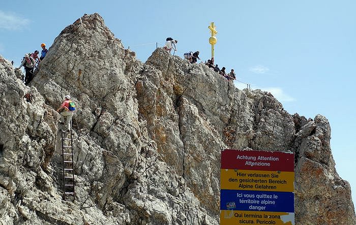
But some won’t be stopped in flip flops to get to the top when they are so close ![]()
So a different rendering for the average Joe would be like this sign.
Cable cars etc. bring them there; ok, there are warning signs like this:
But some won’t be stopped in flip flops to get to the top when they are so close ![]()
So a different rendering for the average Joe would be like this sign.
Would it not be sufficient to define highway=trail as something not normally used by ordinary pedestrians or cyclists, which would otherwise be marked as highway=path?
This way, at least all paths including and beyond sac_scale=demanding_mountain_hiking and mtb:scale=2 would be included, without creating a conflict with things like highway=path + informal=yes in urban areas.
No, I don’t think it will, because as I said above:
Forget about “OSM perfection”, “lazy app developers” are the target here. I don’t think we could get away with this though:
highway=dont_render_this_on_a_general_purpose_map_you_idiot
![]()
As a general rule, if you give a tag a plain English name, its usage will tend towards the common meaning of that word.
It doesn’t matter if you write screeds on the wiki saying “aha, when we say trail we actually mean ‘hardcore climbing path for the experienced only’”. Someone will - entirely understandably - type “trail” into their editor for a nice multi-use path like the Katy Trail or the Taff Trail or whatever, think “yup, this is a trail”, and tag it accordingly.
This is why highway=scramble was a really good suggestion and why highway=demanding_path etc. really is not.
One can argue it the other way round, too:
highway=scramble can be mistaken for this
And with demanding_trail it can be argued that it’s obvious:
I think there is no perfect solution; introducing a dozen new highway=* tag like highway=scramble for every kind of hazardous trail for the average Joe to split them from highway=path is one way to go, introducing a main highway=* tag like highway=demanding_trail the other. Probably a pros and cons collection would help here ![]()
To say “was” may be true, makes me sad a little. Especially, after learning, that the path up to Kriváň very likely prompted one prominent opposing vote in order not to hide it from OSM-Carto. While in reality, the path is tagged sac_scale=difficult_alpine_hiking (which is definitely wrong) which hides it on hiking maps, as @ezekielf mentioned, but lets it still show in all those maps that do not give shit about the subject.
I think, sane editors give a short description, and highway=scramble has one such, that cannot be mistaken for that.
@Quaternion Please remove the twitter link. Such mistaggings happen much more often, there is no reason to put a person on the “Pranger/pillory?”
PS:
I just did that, RfC: highway=desire
I underlying is problem that these are confusing because they are being created in vacuum. There needs to be a set of overly broad levels of difficulty. Each level would imply some combination of “features” that might contribute to the typeof difficulty. It should be modeled on the common difficulty scale.
Before someone asks why not just use sac_value. Hiking scale are usually regional. Inexperienced hikers don’t really understand them. I wouldn’t be surprised if most of them are parents trying to match thier family’s ability to a trail and what kind of equipment is need in order to stay safe.
That why OSM needs a project wide scale where is level should no longer than a paragraph of text and includes a list of subtags common to that level. Resulting in an easy to descrion that is simple to translate without losing meaning.
For example, on a sac_scale=demanding_mountain_hiking (T3) section, you may or may not need hands. In contrast, scramble=yes/no will make this clear. Please note that for T4, a scramble is not optional but one mandatory requirement.
In the end, sac_scale=* is an aggregation, a summary of several aspects – one of them being “scramble yes/no?”. Some of these aspects can be explicitly tagged in OSM as they have their own tag, while others can’t, as mentioned several times in this thread ![]()
IMHO highway=scramble’s definition can never be “sharpened enough”, because it requires us to distinct what is heavily overlapping and thus is “natually” not distinct for certain ways. One OSM way can only be tagged as highway=scramble XOR highway=via_ferrata even tough both usage styles are possible. And climbing UIAA grade I+II is scrambling by definition, too, so another overlap. This dilemma becomes more intense considering other suggestions like highway=mountaineering. This is one main motivation (more in my vote) for the suggestion to introduce a relatively broad highway-value for “somehow demanding paths” (hiding the way in maps+routers for avagerage Joe) and refining that primary tag with secondary tags for the single aspects like scramble, via ferrata equipment, climbing grades & equipment, visibility, harzard of falling, snowfields, waymarks, steepness, firmness of ground, etc. Because these are not values but secondary tags, as many of them may occour in combination for a single way. Thus, we do not need to work out an agreed definition that is clearly telling apart overlapping concepts/taggings/usages like scramble, via_ferrata, climbing and mountaineering but instead their definitions are allowed to overlap as in happens in physical life – if only one applies to a way, fine, if all 4 apply, also fine.
If you have an idea for a clearer definition to tell apart a “normal” and a “demanding” path than I already suggested – which was not convincing at that time – please share your idea, because when I did just read this thread again, an overwhelming majority agrees that highway=path is too overloaded so we shall proceed
12 months later…