The picture shows an orchard that is simultaneousl vineyard, but also seen this week what used to be a meadow_orchard with spaciously arranged olive trees and the surface used to grow wheat or barley or kamut, lavender you name it. How to tag this… landuse=orchard;farmland or what I saw flashing by landuse=agriculture (second picture), which the forum proposed as a prior topic, not at all having my fancy. Yes, sheep for hire too to do orchards round my hill get visited by flocks to shorten the wild grasses growing in between, for that special olive flavour, and if you get that dungy notion, every year each tree gets a spade of it dug into the soil between the roots.NMTSU .P).
1 Like
I’m not necessarily recommending this, I do a lot of orchard/farmland mapping and personally I see them as different types of landuse, ones that don’t have any overlap what-so-ever. Farmland is pastoral in nature, low to the ground woody crops that will be eaten by animals if not picked or otherwise cleared. Whereas, orchards are tall fruit or nut trees that have to be picked. I guess there could be some overlap in cases of crops being grown under the trees, I think it’s called ecological farming, but that’s extremely rare. Anyway, farmland isn’t orchards or visa versa. One more thing to add to that, there can be small orchards in the backyard of a private residence. There usually can’t be farmland in the same situation though. Otherwise, it’s just a private garden. I don’t think a row of fruit trees on their own would necessarily be a garden either.
FTB I’ve gone for tagging the crop=olive;cereal;* whatever is grown in between the trees, semicolon separated. If the density of trees is low I’ve been mapping the trees themselves which is 9 out of 10 olive here i.e. broadleaved/evergreen and tagged the landuse=farmland or meadow as applicable.
That’s probably fine to. The important thing is that it’s mapped. Sometimes it can take a while to figure out the “best” way to map any particular thing, if there is one, but it’s fine if that evolves over time, or doesn’t. Whatever ![]()
Orchards were nearly always used for other purposes than just growing fruit trees (e.g., a crop of hay), but where the two, or more, uses are of equal value there are some terms which have been used on OSM:
- wood pasture: more used for larger trees than fruit trees. Represented across Europe, but in many places by small relict usage. In Spain and Portugal dehesa consisting of Cork or Holm Oaks are characteristic with uses including: feeding pigs (on acorns), pollarding trees for crops of small timber (mainly for firewood), harvesting cork, growing some crops, shaded pasture for pigs and other livestock. There was a small proposal, with some useful comments.
-
orchard=meadow_orchard. As the wiki says, mainly in use in DACH countries for DE Streuobstweise. Some usage oflanduse=meadow_orchard. This is the one I know best (currently managed for wildlife conservation), and mainly meadow rather than orchard as many of the older trees have died, but this is what it looked like in 1968 - A Portuguese contributor suggested something like agroforestry, but I can’t find the wiki page.
Aside from Wikipedia, two English language books which have good accounts of European practice of these overlaps are Oliver Rackham’s Woodlands and George Peterkin’s Meadows. For Central Europe Ellenberg is always an essential text.
Note these practices are not restricted to Europe and occur in slightly different forms across the globe, so it is worth considering them further. Just one example: in Malaysia traditional houses on stilts may be located in an orchard.
3 Likes
TL;DR: It is OK (we do so where I map) for a “base” (larger surrounding) polygon to be tagged landuse=farmland, while “supplemental, more specific” tags of landuse=orchard, landuse=vineyard, landuse=greenhouse_horticulture can “ride on top” of these “base” polygons. Of course, the latter can also be tagged “stand-alone,” without a farmland polygon.
I consider (and tag accordingly) landuse=farmland to be a “generic” kind of Land Use tagging, one where a variety of “Land Covers” can exist. Consider landuse=farmland a minimal tagging which is or can be accurate, but may not be 100% specific as to the type of “farming” going on. (And also consider that “farmland” doesn’t necessarily mean “only row crops.”) That’s why where I primarily map, we have many landuse=farmland (multi)polygons which are also superimposed with additional polygons tagged landuse=orchard, landuse=vineyard and landuse=greenhouse_horticulture. While these both are and appear (from aerial imagery) to be somewhat “treed,” it is correct to call these areas farmland, as whether they do allow tree harvesting or not (consistent with their landuse ), they continue to generate vineyards/wineries, orchards and greenhouses, all prevalent in this area.
Our (local?) conventions also agree we have much “treed farmland,” quite distinct from landuse=forest (what local zoning calls “Timber Production,” where the property owner has an active permit to fell trees and harvest lumber). This has resulted in confused (incorrect) tagging (now corrected) where the farmland, while substantially treed, had its landuse=farmland tag replaced with landuse=forest. But what wasn’t known is that this “substantially treed farmland” really was an “active family farm” (with a farmhouse, sometimes correctly denoted landuse=farmyard with surrounding area including barns and irrigation storage, etc.).
These areas are extremely diverse agricultural areas: in addition to wine grapes, tree fruit and hothouse crops, they generate wild-crafted herbs for aromatherapy, rare mushrooms by foraging at the tree bases, apiaries / beekeeping and other beneficial insect hatching (such as ladybugs to control aphid infestation), etc. All of these are “agricultural landuse” on areas which appear to be “somewhat treed” (though, crucially and distinctly, no timber permits prevent Zoning=TP for Timber Production from being tagged, where then the tag landuse=forest is applied) AND with residences where the owners live and raise these “crops.” And of course, such “supplemental” tags can be used “stand-alone,” without superimposition “over” landuse=farmland.
Some mappers even go an additional step and further superimpose something like a natural=wood or natural=grassland polygon on top of existing landuse=farmland polygons. This isn’t incorrect (i.e. it IS correct), it is merely adding land cover to existing land use.
In short, this stuff is pretty complicated, as we often have two or more “specific activities” going on at once. (For example, viticulture is both farming and a vineyard, and even then, you might want to add the tag crop=grapes as well). The areas I’m talking about are (especially the Happy Valley area of) Santa Cruz County, California, USA.
Finally, “crops change frequently,” so mapping these is a challenge to “keep up to date.”
Landuse is used land, natural land is unused land, from the point of view of a human being. We should not mix opposites.
And yet, we do.
landuse=* might translate to “zoning,” which is “we specifically decree / intend this land be used for a certain purpose.”
“Land cover” is what is “upon” the land (trees, grassland, scree, glacier, bare_rock…) often, but not always with a natural=* tag. These are not “opposites,” as they can mix, and do mix.
That is the opposite of mapping what’s on the ground.
Mmmm, no: a landuse=retail polygon (which at least around here and many other places around here), perfectly captured by the local semantics of “commercial zoning” quite accurately denotes the area of a shopping center, for example. It includes the parking lot(s), the dumpster bins, the landscaping (see what I did there?! there might be trees and grass as landcover!) and the buildings “in the mall.”
It is perfectly correct in OSM to denote the “whole area around the mall” with landuse=retail and yet if some area within it were a nice grassy area specifically to have your lunch from the food court / a picnic or let your kids play or your dogs run in a grassy, fenced area, it would be perfectly correct (too) to add natural=grass right there, too.
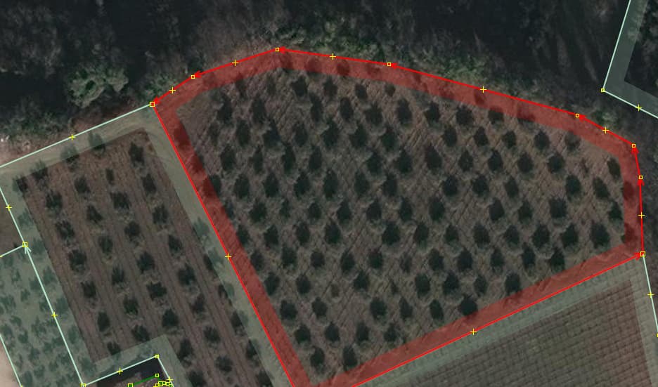
I don’t really feel like getting into a super pedantic debate about the pros and cons of mapping parcel data (or if it’s even something we being doing in the first place), but at least in the example the OP provided there’s no reason to even go though in the first place since it’s pretty clear from the image that they provided us where the orchard/farmland boundaries are. Maybe you could argue it “technically” extends into the woods north of the orchard, but I’d argue there’s no reason map it that way even if it does. Nor would there probably be a way for the OP to the “official” (whatever that means) boundary of the orchard anyway. So there’s zero reason to muddy the matters by suggesting they do anything other then map the clearly visible orchard/farmland and leave it at that. Personally, I’d hate to see their edit reverted by someone who disagree that the orchard extends into the woods even if a zoning map might say so (and there’s no evidence any zoning map does say the orchard/farmland extends beyond the pretty obvious tree line).
In that case I make the tree group or wood patch or scrub zone, or heath, anything none ‘landuse’ an ‘inner’ to the landuse area or if it touches the landuse area outline, map the landuse around it. I’m no fan of letting one area being on top of another larger but I make exception such a residential rural areas which have olive orchards smack in the middle… the orchard probably came first.
Yes, there are myriad such examples: I know some folks who have what are “McMansion” style homes — large >8 bedrooms smack among vineyards. Yes, the vineyards were “there first” (not counting something akin to bare or “more natural” land before humans) and it’s a quirky mix preferred by some upper-middle class types. Olives, grapes, whatever.
These might be “implemented” in OSM in any number of ways, multipolygon relations most frequently, to accommodate “holes” in complex polygons that only are solvable by multipolygons. But however it is done, sometimes there is overlap, sometimes there is a “punched out hole” and it can be difficult to describe how or why one method is “more correct” than another. I’m not saying there isn’t room for improvement in specific cases, there likely is. I know how to use ‘inner’ and ‘outer’ in multipolygons, some do, some don’t, some superimpose instead. It’s a big, messy world and OSM is rather messily tagged.
That are objects on the ground. I only disagree with the use of the tag natural for a maintained piece of grass with a clear purpose.
Because of an increased detail level most mappers that I know are moving away from large encompassing areas to more finer detailed mapping.
For example, landuse=residential is never used to denote the municipal borders. If drivers have to slow down this will already be mapped on the road network.
That all sounds correct to me, @goedegazelle . I’m glad to see that you recognize “an increased detail level” in mapping: yes, “large encompassing areas” which might have been originally mapped as a rough, crude version 1 of things become more fine granulation. In my little city, the city limit is the usual boundary relation, yet it does contain “zoning” areas of retail / commercial, industrial and especially residential. Now, each landuse=residential is a “named neighborhood” (as those were the “first, somewhat crude” neighborhood boundaries), but more recently, these have started to be broken up into rather exact “each block at a time” residential areas (not quite each single parcel, more like a dozen or so at a time, without the property lines between each lot). Then, these are “coalesced back into” what was the surrounding (old-style) landuse=residential area, except when all the “blocks” are done, this polygon has its name=* tag kept, but it is given a place=neighbourhood tag, instead of residential.
Such “incremental improvement” in OSM is well-established, and in my opinion, quite a good thing to do!
I think farmland and orchard and similar landuses are exclusive and should not overlap (at least around here they are not overlapping), farmland could be seen as a generic class of which orchards (and meadows and vineyards…) are a part, or just a class limited to fields, (hayfields?) and pastures and every kind of farming that is not covered by other tags (vineyard, meadow, hydroculture, …)
This just makes life harder for data consumers than it already is. I demonstrated long ago that mapping things ‘on-top’ of other things does not prevent being able to transform OSM data into thematic landcover layers. Alexander Zipf’s group at Heidelberg have long maintained a slippy map of landcover/landuse.
When things are cut out as inners, the complexity of working out what should be, say, a retail area when one is solely interested in that. One would need to take the outer ring of the multipolygon, interrogate each inner to see if it truly needed to be excluded from the retail area and then rebuild a different polygon or multipolygon. My local university has woods, lakes and various other features, but these are emphatically part of the university site, just as much as a clump of trees forming landscaping in a retail park are part of it.
2 Likes
I have been holding off saying this, but as @dieterdreist says this, I must unleash what I have reluctantly concluded about this: the topic of which we speak is similar to the (messy, an ugly word but accurate here) situation with landuse=forest. There are at least six (more, really) various ways this tag is interpreted, especially with how it mixes (or doesn’t) with semantics of natural=wood.
Whether farmland, orchard, vineyard “mix” or “overlap” or don’t is quite similar. In some parts of the world, they do one thing, on others, they do another. We can explain all day “how we do things around here,” and surprise! we are going to find that in some places, things are done differently.
I don’t really have a good “answer” for that, hence this reply. OSM can be messy. I wish this didn’t feel like it might be devolving into “oh, my, what are we going to do?” but it does sort of feel that way.
Further discussion is quite welcome, of course!
I’ve had a couple of people argue with me about how the hundreds of miles of hayfields in my area that are currently tagged as either landuse=meadow or natural=grassland should all be re-tagged as landuse=farmland. I don’t know about that though since I think it muddies the waters to much between pastoral land that is sometimes used for cattle grazing when it’s convenient but not actively cultivated otherwise versus actual agricultural land that is regularly plowed, seeded, and Harvested. At least to me the word “farm” in “farmland” insinuates some kind of farming. Not just “hey this field is empty, has tall grass, and my cows are hungry. So I guess I’ll let them graze here for a while.” Something you might think doesn’t happen much, but cattle herders in the United States love to ditch their cattle on BLM land for long periods just they can eat for free and cause chaos. So I don’t think farmland should include hayfields. At least not in the United states. Admittedly I’m sure that’s different in Europe where the land is way better and more intentionally managed though. Like with SteveA’s example of tagging forest land as landuse=farmland. It works where he lives because it’s usually small, locally kept up and fenced off areas. It would be weird to tag an area of national park where large scale, commercial logging takes place as landuse=farmland though.
Note the little snip of my post you run off with ;o)