I want to add some items in JOSM but I can’t figure out how to edit anything. How do I enable the top portion of the edit menu? Those are grayed out.
I haven’t used JOSM very much. I’ve always done my edits directly to the map.
If you have just opened it most of the menu items will be grayed out unless you have opened something to edit or downloaded some data. It would help if you could provide some more information, perhaps even include a screen shot.
1 Like
Ok, I was just trying edit the map to add some speed limit signs to a few spots. I would like these to show up on the Osmand app map. I might me able to just do it on the Open Street Map online. I read it would be easier with JOSM, so that is where I wanted to try first.
Thanks!
Editing directly in the map might be the easiest way. If you want to do it in JOSM from what I can tell you would first need to download the data information for that area, make your edits and then upload it back to the server.
Hello and welcome to the forum!
JOSM is not as complicated as it seems ![]() :
:
- first download an area you want to edit (green download button)
- do your edits (keyboard shortcut to add geometry is ‘a’)
- when finished, upload data to OSM (upload button) → enter changeset comment → that’s it
Some more reading:
A good tutorial which is based on JOSM (in German, which might be an option though, using DeepL Translate: The world's most accurate translator):
If you have more questions, you can PM me anytime or ask here again.
5 Likes
do your edits (keyboard shortcut to add geometry is ‘a’)
yes, remembering 3 shortcuts will already allow you to do all basic mapping, josm operates in modes, that can also be activated with the upper column of icons left to the map:
a switches to add mode
s switches to select mode
select a node in the middle of a way and hit p to split it (useful if the current ways don’t line up with the speedlimits).
Holding modifier keys (shift, ctrl) while clicking will slightly change the effect (the status bar on the bottom will give you some hints)
There are shortcuts for everything, but in the beginning you don’t need more.
Once selected you can add and remove tags on the “tags” windows to the right, and finally upload with the green arrow up button.
4 Likes
Thank you! I will look at it later.
Ok I have the tiles downloaded and after doing some looking the speed limits are correct in my town. I am not sure how whoever did it, did it. I have read some posts that say simply to split the way at the correct location, but then I read to add a node on either end of the speed zone. What is the proper way to add a speed zone?
What is the proper way to add a speed zone?
usually we just add the limit to all roads in the zone. Then there are additional tags to say they are in the zone, source:maxspeed, maxspeed:type or even more alternative tags, you can find the information in the wiki, but basically there are several alternatives with the same meaning in use.
https://wiki.openstreetmap.org/wiki/Key:source:maxspeed (on the bottom there is a “see also” section)
you can also map the traffic signs but this will not have an effect on routing:
https://wiki.openstreetmap.org/wiki/Key:traffic_sign
1 Like
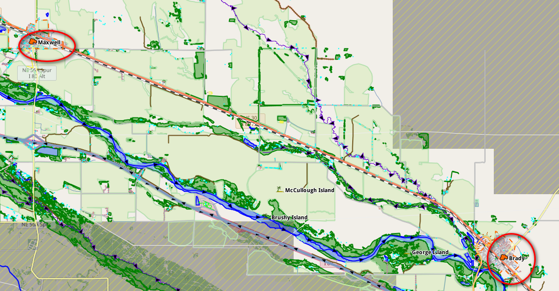
Let me explain my situation, I live in the Platte River Valley of Nebraska (USA) US hwy 30 runs basically along the Platte River and the railroad. Back in the day, there were towns placed along the railroad for perhaps water and coal stope and perhaps passenger stops, about every 12 miles. Some of these towns have ceased to exist, but most of the ones that still exist have speed zones set up through them. Brady and Maxwell as shown in the attached photo have reduced speed limits of 45 mph, which is a reduction from the main 65 mph speed limit on this part of Hwy 30 through them. All I really want to do is place those reduced limits. No, it is not really necessary but I want to do it.
I am retired and need another hobby I guess. On my bi-weekly 200-mile trip there are other speed zones along the route, that may or may not have the speed zones mapped.
I will look into what I need to do to make this “project” happen. As an old friend said on multiple occasions, “A fella needs something to do.”
Set the maxspeed=* tag on the ways that are part of the highway. You may need to split ways first at the speed limit start so you can tag the appropriate maxspeed value for each highway part.
So, maxspeed=45 mph for highways in the speed limit zones, maxspeed=65 mph for the rest.
There are some map paint styles that you can install in josm that help visualize the speed limits on streets.
7 Likes