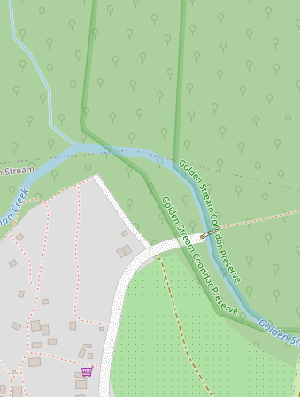
I recently updated the boundary of the nature reserve I work for based on the original land deed and adjusting for irregularities in a river. However, the new shape I uploaded, with the same relation and tags as the original reserve shape, are not appearing in street map viewer. I am new to this - does anyone know where I went wrong?
changeset #161464028
I think it does appear, but the old version is also still there

I deleted the original shape, but both are still appearing. Was my edit reverted, or did I delete it incorrectly? I tried in both JSOM and the online editor.
Changeset #1616468278
Hi, great to see that you are continuing to work on this.
It’s generally not well received if you delete stuff just to immediately create it again. A lot of important history can get lost this way. Just something to keep in mind, please modify existing objects rather than deleting and replacing. It also helps avoid issues like this.
From what I can tell, you first didn’t delete the old shape, so it was still visible. You then deleted a bunch of lines which marked its boundary, but that isn’t enough, because the river is part of the boundary. If you want to completely remove the relation, you have to first remove its members (don’t delete the river, just remove it from the relation) and then delete the relation itself (some tools do the last part for you).
As always, if you want to quickly see your results, wait a few minutes and then force-refresh the tab (Ctrl + Shift + R).
Do you have any tips for editing existing shapes as opposed to deleting completely? I needed to input a different shapefile as there were many discrepancies, but I was unable to figure out how to input the new shape while retaining old, relevant data.
Additionally, the Western boundary of the new shape is a better approximation of the river than the existing Golden Stream river line. Is there a way to derive a river from a line/boundary?
Ideally, you’d have a sort of preview mode. Lacking that, I’d consider it fine to upload your reference shape, move the old shape over to the new shape, and then delete your reference.
I notice that your shapes are single (closed) ways. This leads to some duplication, where boundaries are shared. You can split ways (in the online editor – ID – select the way and a node, then press X). If you do it once at the start and the end of the shared boundary, you can add that way to both and don’t duplicate it.
Without the appropriate tags, no. You can move the river to your new boundary though. Select a node of the river and move it on top of a boundary node. The river is already part of the old shape, though you might have to check that it’s connected correctly.
Is there a way to undo my previous changesets so I can edit the feature the way you just described?
In JOSM the utilsplugin2 plugin has a replace geometry function (More Tools → Replace Geometry). But you still need to manually address topological issues - if any.
The function I use a lot in JOSM to preserve chronology/history is Crtl+Shift+G. Select old outline and new outline, hit the key combo and the tags get moved plus history and the old object is removed. It will even handle relations, multiple depending on how the origins were mapped.
One caveat: It will not always work, particularly, the original should not have and changes made in the current edit session and when nodes of the object are glued to other objects. Using this massively particularly on poorly drawn buildings. Map the building again properly, change bad outline and new and the change is instant, no loss of history. Even if you cut a long way in e.g. a wood outline it works to move all tagging to the new outline piece preserving history and multipolygon relation links.
NB You need to have the Utils2plugin added to JOSM for this and many super nifty quick mapping fixes to execute.
PS This Ctrlt+Shft+G works for node to area as well, a parking node converted to area e.g. Does not work the inverse, area to node (POI), dearly love to know how then to preserve chronology.