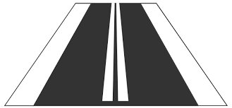
Can a road marking split a road to 2 ways?
As this one:

OpenStreetMap
OpenStreetMap is a map of the world, created by people like you and free to use under an open license.
Can a road marking split a road to 2 ways?
As this one:
What kind of road marking? Also, do you mean splitting a way into two shorter ways connected by a node, or do you mean a dual carriageway (two parallel ways)?
Simply put: yes it can.
A classic case is slip roads. They are split away from the road being exited or not joined to the road being entered well away from the point a verge separates them from the main carriageway. At that point only a road marking delineates the separation.
Why? To avoid absurdly unrealistic and ugly geometries. To reflect the reality of traffic movements and routing. Sometimes there are other reasons as well. It’s a complicated and nuanced question to decide when to split a road’s carriageways and when not to.
Overall, splitting a way with a flush median is generally seen as a mapping error on OSM and should be corrected because of access regulations[1].
The most common exception is when a dual carriageway temporarily becomes a single carriageway because of left turn lanes and in some cases, drawing a dual carriageway might be the only sane solution thanks to the amount of traffic islands on that road even though the default state is single carriageway.
And of course, as mentioned above, there also is a point when the painted separation becomes so large, it’s more accurate to treat ways as dual carriageways than single carriageways despite the current state of reality.
These being left turns but more importantly, overtaking ↩︎
I mean a 2-way road to be splitted to 2-1 way road
@ManuelB701’s answer is correct: we only map a dual carriageway if there’s some kind of physical barrier (such as a grassy median or guardrail) separating the lanes, and painted markings generally aren’t considered barriers for this purpose. Among other things, this approach keeps us from having to create lots and lots of artificial crossovers for the places where you can turn on or off the roadway.
However, if you aren’t allowed to turn across a painted median and it’s a very wide median, some mappers do create a dual carriageway. Personally, I wouldn’t normally do that along straightaways, but I’ve noticed that it’s common in Belarus, for example.
At least in Germany, we also consider road markings as “physical” barrier, as you are not allowed to cross them and as the road is considered as two oneways by law.

After all, the rules of physics differ from country to country. In some countries, thermoplastic road markings are physical phenomena, but a curb separating a sidewalk from a roadway is all in our heads, a construct. ![]()
Luckily in most rural areas in the US there is also about a feet of green between curb and sidewalk ![]()
That’s suburbia you’re thinking of. The real rural areas don’t have sidewalks or pavement ![]() .
.
Is that so? I never heard that before. Do you have, for example, a discussion where this was a consensus?
In my memory it is just the other way around. Only for really wide markings, where for example parking takes place in the middle, the separation was considered wide enough for seperate mapping.
In driving school we learn to treat these painted areas “as if they were a physical barrier”. I think that’s what @aighes is referring to.
But it’s definitely not consensus to always map this constellation as 2 separate ways. The only thing that is consensus is that if 2 lanes are physically separated, then they should be mapped with 2 separate ways. Physical separation in OSM does not include paint.
The consensus doesn’t say anything about when to map 2 non-physically separated lanes as separate ways, so this is up to the mapper’s discretion. There are cases where it makes sense to map them separately, and there are cases, where it doesn’t.
A legal barrier is not a physical barrier. You can use change:lanes or overtaking=no and restriction relations for legal barriers.
The distinction between legal barriers and physical barriers is e.g. relevant for analyses of traffic safety, ordinary navigation devices that show the layout of the carriageway (including lanes you are not allowed to drive on), as well as routing of emergency services which are exempt from legal restrictions.
Althouth you see that the GPS tracks show distance between the 2 lanes you dont consider the diagonal painted stripes?
Diagonal painted stripes are considered as a “dead” area on asphalt and they should be marked as pfysical objects.
I understand your point. I’m not dogmatic about the physical separation principle, because sometimes it prevents us from mapping useful information about road geometry, but it is still a good rule of thumb.
In the U.S., painted crosshatched dividers often separate the two sides of a two-lane expressway. A chevron divider can also divide the left turn lane from the rest of the lanes; there are reasonable arguments for and against mapping a separate way for the left turn lane. And I’m firmly of the opinion that slip lanes separated by painted pork chop islands should be mapped as separate ways.
The space between the left turn lane and through lane isn’t an emergency lane. It’s a virtual traffic island or gore area, which in this case happens to be painted with chevrons to discourage travel within it. Often, these virtual gore areas aren’t suitable for cutting across in a vehicle, because you’d run into debris, a paved drainage ditch, or other obstacles within it. This abandoned proposal summarizes the attempts to define a tagging scheme for these virtual gore areas. This JOSM lane pl…
Ultimately, the physical separation principle is a good idea, but sometimes we make exceptions because there’s something important we need to communicate on the map about road geometry or movement; legal abstract classifications aren’t the deciding factor but may inform our decision. If the divider is thin enough to function like a standard lane divider and it has a consistent width, then alternatively a tag on a single carriageway can communicate the same information just as effectively.
A classic case is slip roads. They are split away from the road being exited or not joined to the road being entered well away from the point a verge separates them from the main carriageway. At that point only a road marking delineates the separation.
this is wrong and incorrect mapping and such cases should be repaired
At least in Germany, we also consider road markings as “physical” barrier, as you are not allowed to cross them and as the road is considered as two oneways by law.
though it should not be mapped as dual carriageway (two lines, each with oneway=yes) in OpenStreetMap.
Don’t confuse the way of driving with the the way of mapping
No it isn’t wrong. It’s standard practice.
If we went with what you’re suggesting then geometries would be hopelessly distorted at large road junctions. Slip roads would simply emerge out of dual carriageways at right angles and we would be laughed at by any serious cartographers.

OpenStreetMap is a map of the world, created by people like you and free to use under an open license.

OpenStreetMap is a map of the world, created by people like you and free to use under an open license.

OpenStreetMap is a map of the world, created by people like you and free to use under an open license.

OpenStreetMap is a map of the world, created by people like you and free to use under an open license.

OpenStreetMap is a map of the world, created by people like you and free to use under an open license.

OpenStreetMap is a map of the world, created by people like you and free to use under an open license.
ALL of those junctions feature slip roads merging with and separating from main carriageways away from where a physical barrier between the two starts. In most cases they separate where the solid white line between the two carriageways starts. So a road marking rather than physical barrier separating them.