I am curious as to why some Shared Paths display as solid blue lines on OCM vs. dashed blue lines. Examples are in City Beach area at Oceanic Drive/Challenger Parade intersection. The path alongside Challenger Parade displays as solid line whereas path alongside Oceanic Drive is dashed. When using Potlatch, both display dashed which is what they should be. There are some differences in tags which I don’t think should be significant.
Can you confirm which map you are looking at? I don’t see any solid lines around that intersection on the default map at www.openstreetmap.org .
Some of the paths are tagged as “paved” which may lead to a different display in some renderers.
1 Like
In CyclOSM dashed line means worse surface. In OpenCycleMap - I’m not sure, their key to symbols seems incomplete to me.
2 Likes
Are you speaking of his region here?
The bike path along Challenger Parade is part of a relation (Relation: Indian Ocean Shared Path (14235232) | OpenStreetMap), which might be the reason it’s rendered differently on OpenCycleMap.
Some bike paths change to solid lines in “Cycle Map” view.
In “CycOSM” view all bike paths are bold solid lines which seems to be a characteristic of CycOSM.
I will look into the “paved” tags. All of the bike paths in this area are paved but not all are tagged as such.
And, Habi, that is the correct region.
Andy Allan responded to my query as follows:
Recently I changed OpenCycleMap to show the surface values of the paths,
where hard surfaces are a solid line, and soft surfaces a shorter dash
than default. You can read more and see some examples here:
3 Likes
In “CycOSM” view all bike paths are bold solid lines which seems to be a characteristic of CycOSM.
This seems to be not true. Here is an example of dashed cycleway in CyclOSM:
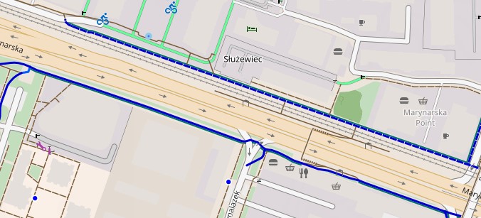
and here is the part od CyclOSM key to explain it:
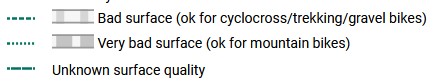
I agree that CyclOSM does display dashed lines but the legend on the web version does not show this, only showing the solid line type.
I have checked some cycle paths for which I updated the tags to reflect the surface conditions, and they do display as dashed lines where the surface is unpaved. However, I feel that the dashed lines are not very obvious as the gaps between the dashes are grey not white.
See CyclOSM: OpenStreetMap-based bicycle map
The good news is that the rendering of both CyclOSM and OCM appears to be consistent for pave/unpaved paths so it is worthwhile for mappers to add/correct the path surface tags.
It would be nice if Potlach3 displayed the paths solid or dashed accordingly. All are dashed.