frankly what you guys are doing is outrageous, filling the map with data made with artificial intelligence without verification does not make you heroes, it’s not help but vandalism
ex; city of Oum El Bouaghi Algeria,un travail de 8 ans démoli en quelques clics
If you have a problem with anyone’s edits you need to either contact them directly or contact the DWG about them not make wild accusations at the community in general.
3 Likes
Er, what? Here is the history of the node and here is the history of the relation. Neither has been modified since 2021.
Can you explain in more detail exactly what has changed and if possible when it changed?
1 Like
Last edit in Oum by a mapper who’s name rings a bell. Done a few corrections to Dolores’ work in past. Changeset: 139193864 | OpenStreetMap. 5 issues per CS summary, enclosure wall going through buildings does not seem right. Anyway, overpass achavi - Augmented OSM Change Viewer [attic]. Maproulette always gives me the heebie-jeebies
@Kaliphe, if you got a specific edit set you have gripes with, please address the mapper(s). And yes, working with MapWithAI, every single building needs correction in shape and orientation and many many splits at times. Conscious and conscientious going about it can work, but is very dependent on quality of sat imagery against which checks are made.
Bonjour kaliphe,
Comme l’on dit les autres intervenants, on doit d’abord bien documenter les problèmes rencontrés. À partir du changeset identifié par SekeRob, je constate que le contributeur mentionné, en participant à un défi MapRoulette, a fait de nombreuses modifications en Algérie au cours des dernières semaines. Ce défi visait uniquement à corriger les situations où une route croise un/des bâtiments. Je vois que la géométrie de batîments rectangulaires a été modifiée de façon un peu fantaisiste. L’image Bing est relativement imprécise et il est difficile d’interpréter les images si on ne connait pas la situation localement. Et oui, il est frustrant pour les contributeurs locaux de voir telles interventions de l’extérieurs si mal encadrées.
Svp nous indiquer si le problème vient bien de telles modifications effectuées dans le cadre du défi MapRoulette ou s’il y a d’autres types de problèmes. Le mieux pour faciliter la discussion est de fournir les no. de changeset. Il est important d’identifier si de tels projets pilotés de l’extérieur du pays où des contributeurs peu expérimentés causent des problèmes de qualité et de corriger la situation. Il serait aussi possible de voir ensuite avec le groupe DWG de la fondation OpenStreetMap si on peut envisager d’annuler ces modifications et revenir à la situation précédente.
2 Likes
it’s a groupe of editors so i can’t do it alone
i’am talkin about the city and the rounds, and exactly about metadata, like height, levels and so on
I tried looking (with OSMcha) for users that edited height=* or building:levels=* in Oum El Bouaghi starting from 1 Jan 2022 and you are the only user that pops out
could you link one (or more) changeset to help us understand the situation better?
6 Likes
if it’s not vandalism then what do you call it, he removed several buildings that existed without explanation, yet I live in the same city
this is the vandalist numide | OpenStreetMap
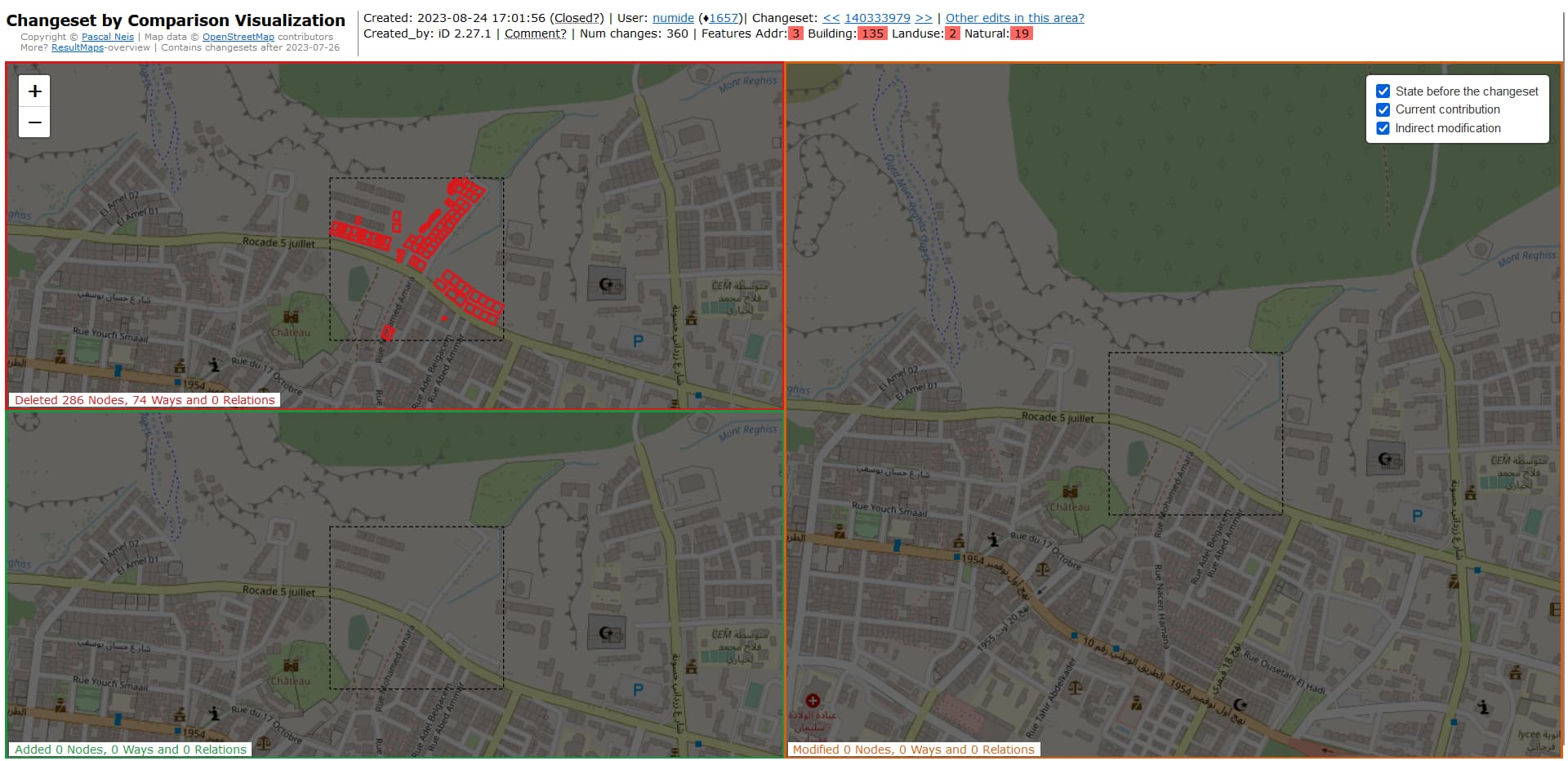
OpenStreetMap Changeset by Comparison Visualization
1 Like


Given the works I’ve done with MS Footprint AI aided building mappings, not worth the bits written in. Too many are a product of image artifacts and too often container, trailer, large trucks, shades of buildings are included and thus the shape is affected by the time of the day they were imaged and the angle the image was photographed at.
The scary part, there’s 17 and a quarter million of these buildings already imported into OSM… not going to hold my breath as to the number that were actually edited for shape correction post import or deleted as false prior to upload.
2 Likes
Thanks for the changeset number!
That particular changeset has now been reverted, as I see.
In the future, when you spot such problematic edits, please comment in a discussion on that changeset first in friendly way and providing clear description of problem and other data (i.e. always assume good faith, even when if are quite convinced there is none - in fact, especially then!)
E.g. you could add changeset discussion (on that link above) with:
“Hi, I’ve noticed you’ve deleted multiple buildings in Oum El Bouaghi Algeria, while they are clearly visible on Bing aerial imagery (as well confirmed to be existing on the ground by me just a month ago). You also seem to have been doing similar deletions in some other changesets. Why is that?”
Commenting on a changeset serves several purposes:
-
it contacts the mapper that made a change, letting them know that they are doing dubious things (I know there is possibility that this is intentional vandalism. But there is also a possibility of newbie making mistake or not knowing what they’ve done (e.g. they were learning and clicked save by mistake). You can also put link to community post like this one (if it is already opened) and invite mapper to read it and respond.
-
it documents the problem and the fact that you tried to contact the mapper, which is prerequisite for escalating the problem to the Data Working Group to warn, block or even ban the user and revert problematic changes if the user fails to respond (or responds in hostile way). Ideally, you would have several changes that you or other mappers commented on, and include them in your report.
-
friendly and non-attacking tone helps (or at the very least civil, non-emotional and sticking to the facts) in multiple ways:
- it will help your case if matter needs to be escalated to DWG - being overly unfriendly and aggressive could earn you a warning/ban too. Remember, OSM is all about community!
- being unfriendly and aggressive will automatically put the other person in defensive mode, thus reducing the chance that situation can be resolved peacefully and increasing the probability the attached person will want revenge. Also, when they (almost invariably) attack back, then you too will become more aggressive, thus escalating in feedback loop.
- Nobody is perfect. We all make mistakes. Being civil and friendly (instead of unfriendly and aggressive) will help a lot when it sometimes happens that the edit was actually valid (e.g. imagery is old and buildings were indeed demolished due to reconstructions) or when person was not a vandal but a newbie who made a mistake. You don’t want be the one looking like a jerk when that happens.
- being friendly and helpful in all communication helps attract new mappers. If all they could see is people on both sides calling other people names and not being civil, they’ll (rightfully) run away.That could end up being more damaging to the project then the incorrect edits!
- it always helps to remain calm, our higher brain functions stop working good when we’re angry (see e.g. No Angry Mastodons article)
- really, it is always beneficial to everyone if tone is kept civil and to the facts, instead of assuming the worst and engaging in name calling.
(note: this is general advice, intended to be helpful and not accusative. In other words, when you see word “you” or “one” or similar, it is meant as any person spotting a problem and wanting to report it, not any particular individual)
3 Likes