My main goal is to move away from using legal access tags to subjectively decide the suitability of a path for a motorcycle or any other means and use instead the appropriate activity scale tags (more on this later in a separate wiki revision topic).
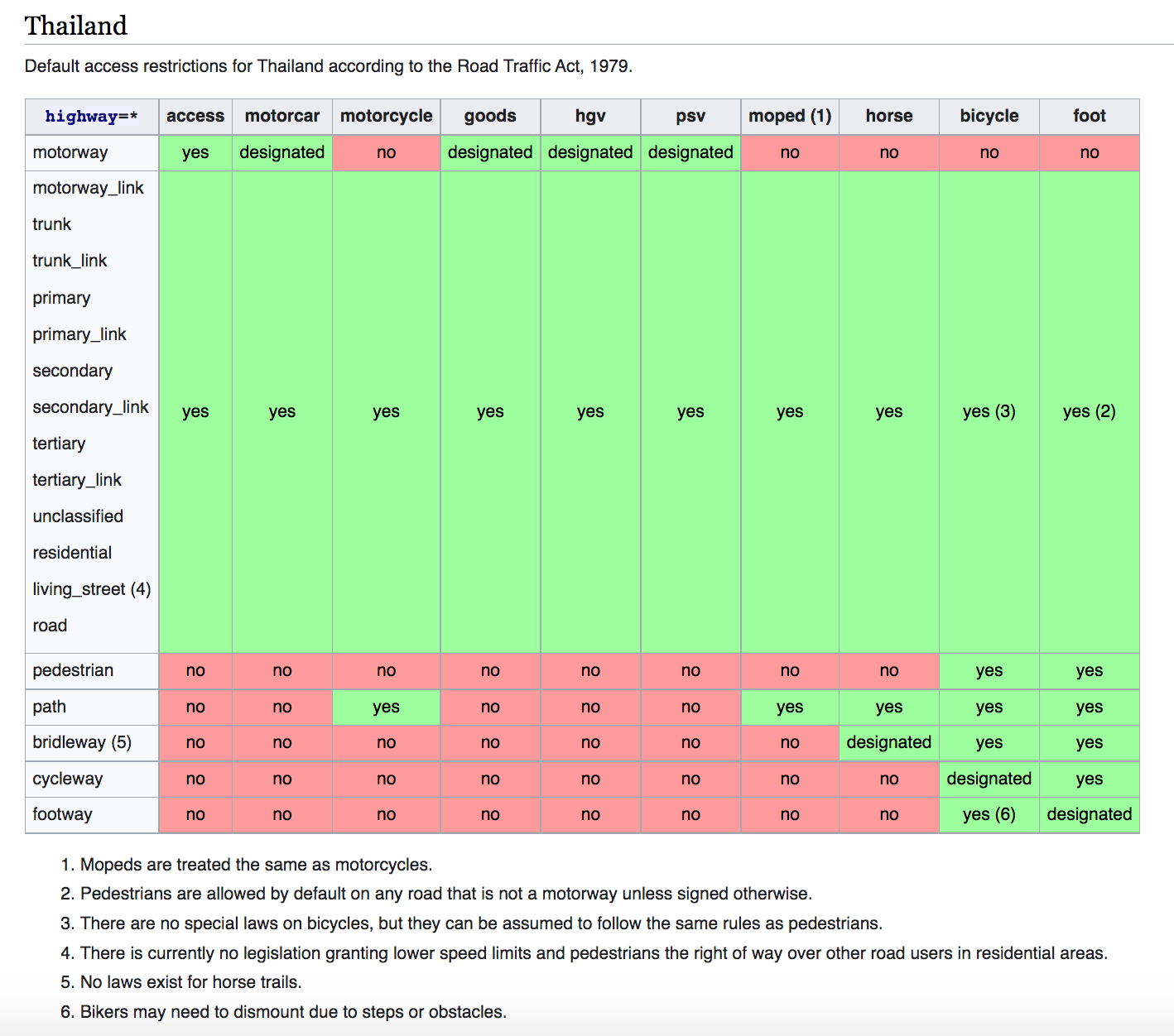
For background, the default access restrictions do not include motorcycle=yes for highway=path, and motorcycle=yes has been used primarily instead to indicate the path suitability for motorcycles which is a very subjective matter.
Also, the default access does not reflect the current law for e.g. motorcycle restrictions on motorways, and it would be great to document the current law restrictions (ROAD TRAFFIC ACT, 1979).
My proposal would be to look at the Philippines table which I believe should be very similar to Thailand, and adapt its notes to Thailand specifics:
What do you think? Is anyone familiar with the law? what would you change from the Philippines example ?
Most of the Philippines table matches the situation in Thailand, with the exception of the motorway, which, as you mentioned, is prohibited for motorcycles.
By the way, I think the motorway_link should be motorcycle=yes by default. There are some small road branches off the motorway_link before the toll gate, so it should be motorcycle=yes. Since the main motorway is motorcycle=no by default, the routing engine would not allow a motorcycle to pass through the motorway. This would require the creation of a new row for motorway_link.
Some mappers keep using this to map streets in gated communities where people live.
The table should list this tag on a dedicated row and indicate that the tag should not be used.
I can well imagine that government might decide to introduce this isln the future. So we should not change the international established meaning of the tag.
I mean these motorway_link can be used to reach the other road (e.g. residential), if the user doesn’t pass the toll gate or doesn’t reach the main motorway.
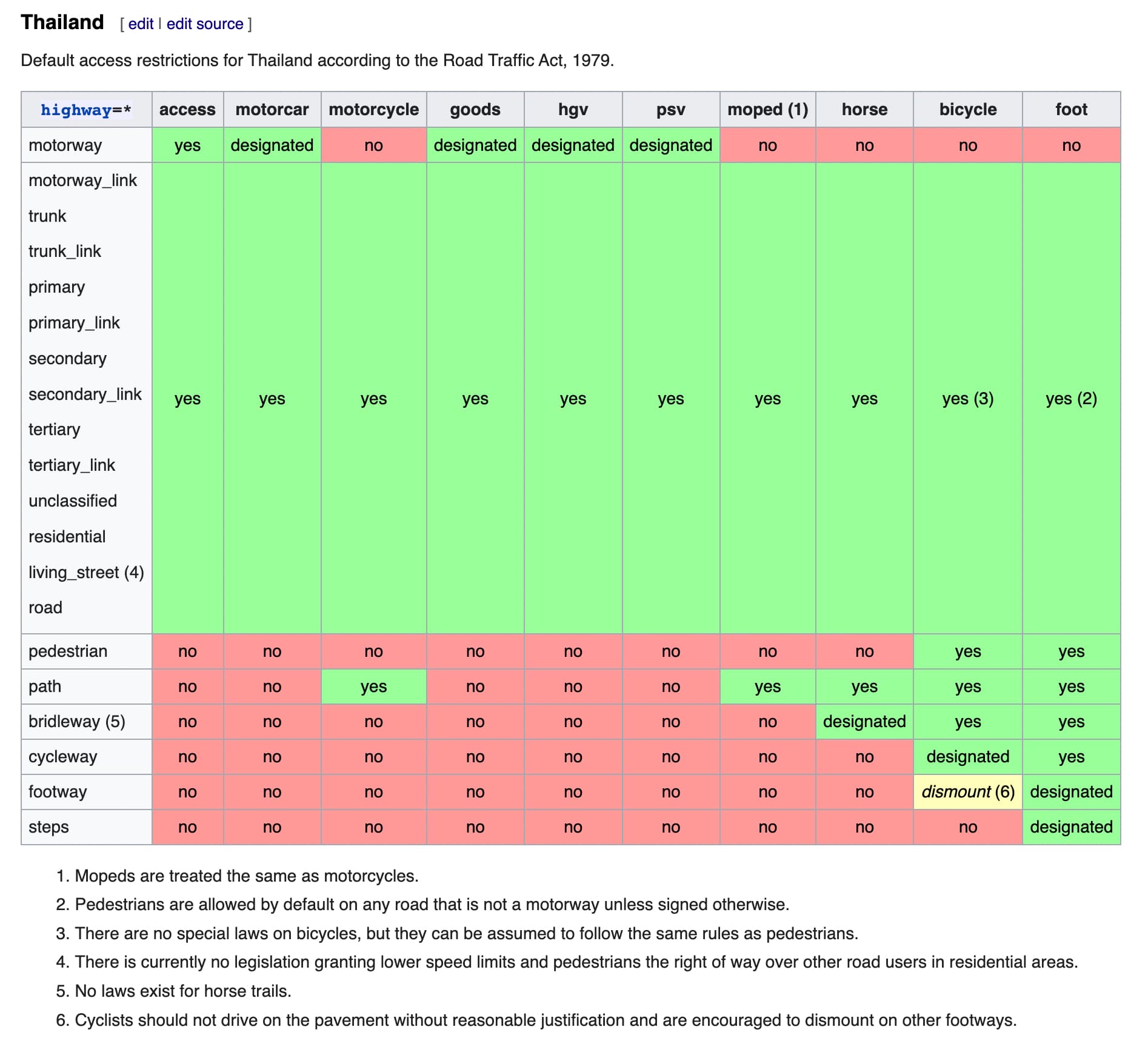
This row of living_street already exists in Thailand Wiki’s highway classification table, and it should work fine. According to my understanding, this access restrictions table is not intended to be used by mappers to tag highway classifications, but rather as a guideline for routing engines.
Not an official translation, but this government pamphlet says that:
bicycle should not drive “on the pavement without reason” (Page 9)
There is no reference about it in the official BICYCLE chapter 10 of the Road Traffic Act (1979) but this would match with the section 43. of the general Driving (Part 1) under USE OF ROAD (Chapter 3).
“No driver shall drive: (7) on the pavement without reasonable justification, except a baby carriage or wheelchair for patient or disabled;”
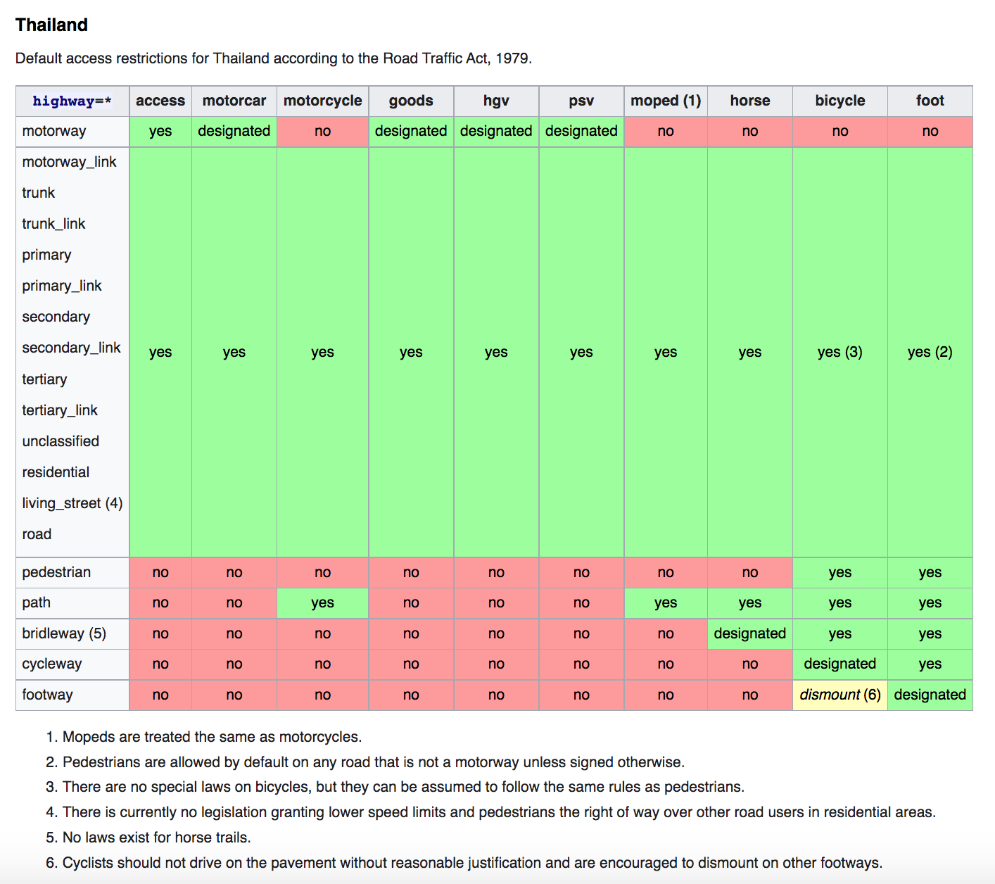
So I would suggest to make the default access tag bicycle=dismount under highway=footway, like some other countries have done.
An alternative would be to make a subsection dedicated to sidewalks but I would rather keep things simple in Thailand, since sidewalks are rarely tagged in Thailand, and I find it strange that bicycles can ride (unless signposted) on hotel/attraction footways which often include steps.
If a specific footway allows bicycles to ride, the extra bicycle=yes can be manually added.
If a specific pathway is meant exclusively or primarily for bicycles, it should be tagged anyway as highway=cycleway.
Thanks for research. I checked the terms and found that the law only applies to the sidewalk of a road (Section 4 (11)). As a result, there is no law prohibiting riding on a footway that is not a sidewalk.
Both approaches have pros and cons. If the map is detailed mapped, obstacles such as steps, gates, and so on should be mapped and tagged with access=*. By the way, I understand your concern that Thailand is still roughly mapped, so keeping it simple may be preferable (with the notion that it may become more detailed in the future).
For sidewalk, I’m not worried much because it’s rarely mapped as a separate way from the main road.
In conclusion, I think bicycle=dismount is acceptable and maybe more suited for footway, because if the path does not appear to be exclusively for pedestrians, highway=path should be more appropriate.
It’s a take over from footway with standard defaults to clear possible confusion vs path/footway, as other countries have done in the wiki.
The Road Traffic Act is quite limited so it only give us an interpretation of what could be sensible defaults. To reflect this, I have changed the summary from “according to" to "based on the interpretation of”.
Update: I’ve moved the default restrictions table from the global wiki page to the Thailand wiki page. The global page is becoming obsolete due to conflicting information from other countries.