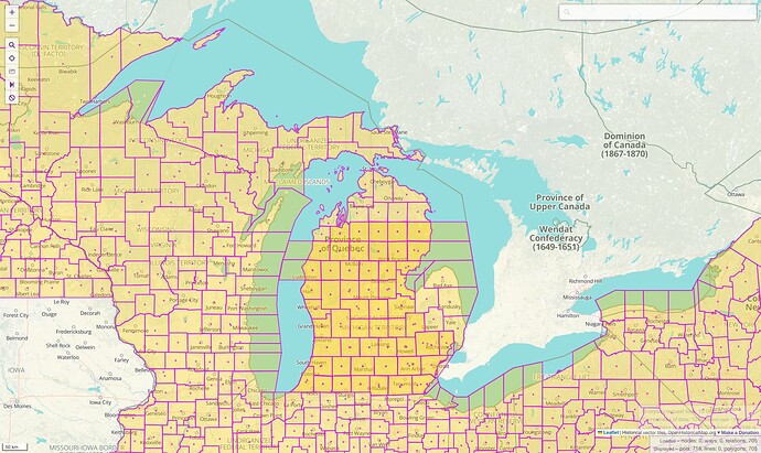
OSM currently makes some questionable decisions regarding the boundaries of counties adjacent to the Great Lakes, namely in Michigan. Some of us have been grappling with the situation independently for a while, so I figured it would be a good time to start a public discussion about it so we can all get on the same page.
Lakeward boundaries were the subject of a megathread in OSMUS Slack back in 2021. The consensus for New York and Ohio was that counties do include territory within the Great Lakes, all the way to the state line or international boundary with Canada, but mappers in Michigan held firm that counties there end at the shoreline. This is more or less the current state of affairs on OSM:
For readability, maps for nontechnical audiences conventionally omit lakeward state and county lines, just as they omit most international maritime limits. For that matter, few maps show Michigan’s actual boundary. But if we’re going to show these county boundaries at all, we should make sure they’re accurate and complete, so that data consumers can choose to hide the parts over water as desired.
The federal government has standardized on a comprehensive set of lakeward county boundaries that features nonobvious details even in Michigan. The public sees this representation most frequently in weather maps on TV (via the National Weather Service), federal publications such as The National Map, and reference works like Wikipedia that defer to the federal point of view.
Before you scream TIGER! Beware!, I should point out that the much more polished decennial Geographic Areas Reference Map series and annual Boundary and Annexation Survey (BAS) reference map series both feature the same contours and angles into the Great Lakes without the frequent perturbations characteristic of TIGER boundary data. Some states like Michigan participate in a program that gives the state an opportunity to sign off on changes to BAS maps. Still, as far as I know, the federal government only publishes these reference maps but has never published a compendium of relevant legal boundary descriptions that would justify the boundary shapes.
Last year, OpenHistoricalMap opened this can of worms by importing the Newberry Library’s Atlas of Historical County Boundaries (AHCB) as a starting point for further local boundary mapping. The AHCB made an unfortunate editorial decision never to extend boundaries over bodies of water, even contradicting crystal clear language in the legislative acts they cite, in order to facilitate animated line maps of boundary evolution.
A few of us have been gradually researching these contradictions based on a close reading of the cited acts, extending boundaries out into the water and thereby cleaning up some really nasty coastline ways. We’ve finished working through several states, including New York and Ohio, where some counties historically cut off another county or played hot potato with an island. A war with Michigan was the very reason for some of these lakeward boundaries.
Michigan presents a special quandary: in the vast majority of cases, a county was legislatively defined as a set of PLSS survey townships. Over time, some laws did begin to specify the lakeward boundaries, especially near the contested borders with Ohio and Wisconsin. In some cases, a county line was defined in one of the lakes, only to be repealed in favor of a list of survey townships and islands when the legislature split or merged a county.
I’m leaving some notes on the wiki as I go along and encourage others to contribute to the page. There are still more counties in Michigan to research, but already the result differs markedly from both OSM’s consistent shore-hugging approach and the federal government’s consistent space-filling approach.
In some cases, OSM is the only one claiming that the boundary hugs the shoreline, but there’s still a disagreement over where exactly it runs. By law, Menominee County extends 3 miles (4.7 km) into Green Bay, out to a boundary between two survey townships. But for some reason, the federal government places this boundary more than 13 miles (21 km) farther to the east. I detailed this discrepancy in the OHM Forum:
Compounding matters, OSM hugs the shoreline. This creates a gap in the boundary between the Eastern and Central Time Zones, which is defined in terms of the Menominee County line. OSM closes this gap with a diagonal line running from the shoreline to the state line that doesn’t appear to match the relevant regulation.
Aside from Michigan, there’s also some question as to whether Pennsylvania’s Erie County extends into Lake Erie. I guess it’s a bit of a moot point, since that county is unique within the state and the state can have jurisdiction over the lake regardless of whether it’s part of the county’s territory.
Looking up individual acts cited in the AHCB yields a lot of insights, but this approach falls short of proving anything about county boundaries overall. It’s entirely possible that the researchers at the Newberry Library overlooked some act or judicial opinion that changed how the boundary descriptions should be interpreted, even statewide. After all, apart from the federal reference maps and AHCB citations, our depiction of Ohio’s counties and townships partly rests on a state attorney general’s opinion from 1960. This is where local mappers come in: what have you been told or taught regarding the counties’ lake-facing boundaries? Are there any resources you could find for an individual county that a researcher in Chicago or California would overlook?


