As I understand it, a crossing=unmarked is still a specifically designed or designated crossing like any other crossing,
I don’t think it has to be designated or designed, (according to where it is) there may be many places where pedestrians arrive at a road and there is something at the other side of the road which makes them cross the road (could e.g. be an amenity or also a path that starts/continues there), but without any crossing infrastructure whatsoever.
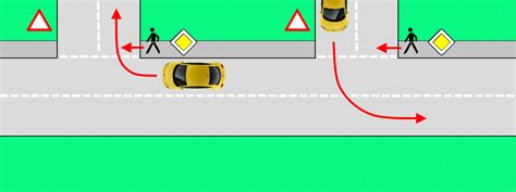
Pedestrians have priority when crossing side roads at junctions. Traffic leaving or entering that road should give way to pedestrians.
The direction you are turning in makes no difference. The continental concept of priority to the right does not exist. Vehicle priority is indicated by road markings (with the addition of signs on main roads).
Traffic entering, or leaving a junction is obviously going fairly slowly anyway so slowing for pedestrians is no issue. A zebra crossing is a point where you are expected to slow or stop on a main road from travelling speed.
As you approach a zebra you should be checking for pedestrians approaching the crossing and slow or stop if necessary.
Also going a bit off topic, but for the situation you describe, with no crossing infrastructure whatsoever, we now have crossing=informal. This is to distinguish it from situations where there is at least a dropped kerb, tactile paving or an island or but no road markings (crossing=unmarked).
Also going a bit off topic, but for the situation you describe, with no crossing infrastructure whatsoever, we now have crossing=informal. This is to distinguish it from situations where there is at least a dropped kerb, tactile paving or an island or but no road markings (crossing=unmarked).
interesting, I would see this as a subset of crossing=unmarked
It’s not the same. crossing=informal is used where you can and may cross the road, but there is no visible infrastructure. Meaning: the only way to know it’s a pedestrian crossing, is because a footway/path and another highway are crossing.
Back to topic.
I see that there are 2 different suggestions:
crossing=sidewalk/pavement to indicate a continuous sidewalk. Would be odd in situations where the footway/cycleway crossing isn’t actually a sidewalk. The same holds true for continuous_sidewalk=yes.
highway=highway_crossing or similar to indicate that the “highway”/carriageway is crossing the footway/cycleway/path, not the other way around.
I wan to stress that this about a “crossing” that looks like your regular driveway going over a sidewalk with the complete absence of any kerb or crossing indicator like tactile pavings.
Personal opinion: crossing=sidewalk is easy to grasp, even if there’s 1% of these types of crossing, where the footway crossing is probably not a sidewalk. Would native speakers have issues if this attribute was put on a crossing with a “highway” and a cycleway? If so, would something like crossing=footway/cycleway/path instead make more sense?
See I just looked at the pictures on the wiki and it seemed like the best fit to to me. I’m a simple man who sees what looks like a crossing and maps it as a crossing, while lacking awareness of these legal nuances .
Fair enough. I wasn’t using the term “designated” very deliberately there. I was just clarifying that you wouldn’t litter a road with crossings just because someone could physically walk across at any arbitrary point, and you also wouldn’t litter a sidewalk with driveway crossings either. Feel free to communicate that point in a different manner.
(In my dialect, it’s very common to say “designated crossing” to mean “a place where common sense tells you you’re supposed to cross”. It doesn’t mean the mayor has signed an ordinance dedicating it to pedestrians. But I should be more careful throwing this word around in an OSM context, where designated has acquired more than one specific meaning.)
Anyhow, it sounds like we agree that a crossing necessarily allows crossing after all.
What I meant is that crossing:markings=surface may accurately describe your example, but we’d be reading too much into this tag by assuming it gives pedestrians the right of way, since usually the reverse is true.
Going back to your example:
I agree with your observation, but for a different reason: traffic on Bank Street must stop for pedestrian traffic, as indicated by the stop sign and painted stop line, whereas the pedestrian street has no signage or markings to indicate that they must yield the right of way, not even a curb. It doesn’t matter if the crossing is distinguished by these brick pavers, zebra stripes, or polka dots.
In other words, this is a two-way-stop intersection, not a mid-block crossing. Maybe the most appropriate tag here is highway=priority rather than anything crossing-related:
I look forward to someday deprecating the crossing=* key outright, so we can get out of the business of evaluating priority and right of way when it follows the regional default anyways. It would be up to a router to recognize that a pedestrian doesn’t have the right of way at a mid-block highway=crossingcrossing:markings=surface in the U.S. (with an implied crossing:signals=no and crossing:signed=no), so it should penalize the crossing accordingly. A table on the wiki, or better yet a machine-readable file in a Git repository, would be very useful for harmonizing these inferences.
In the meantime, as long as we’re explicitly classifying crossings, we should avoid introducing tags that mislead when taken at face value. It’s already bad enough that a zebra crossing is not where zebras cross and an uncontrolled crossing is by definition controlled by markings. If a crossing is marked by something that isn’t legally recognized, I’d hesitate to classify it as a marked crossing, but crossing:markings=surface can still apply.
Fair enough. I wasn’t using the term “designated” very deliberately there.
yes, this is what I thought
I was just clarifying that you wouldn’t litter a road with crossings just because someone could physically walk across at any arbitrary point, and you also wouldn’t litter a sidewalk with driveway crossings either. Feel free to communicate that point in a different manner.
I don’t think we must map highway=crossings on every driveway, but what is definitely worth to map are the kerbs along driveways, particularly when they are raised, these can become a real annoyance, e.g. for wheelchairs, children on bikes or with a pram.
Fun fact. I mapped a sidewalk separately the other day. It crosses a side road using the continuous footway design that we have been discussing. I didn’t tag the crossing node at all, instead I opened this thread to find out how it should be tagged. Now a StreetComplete user has been asked “Is there a crossing here?” and they selected “No, but crossing is possible here”. This has resulted in the tag crossing=informal on the continuous footway. That’s obviously wrong, though I can’t blame anyone. It just shows that we need a tag for this situation (and once it’s been agreed I’ll open an issue in the StreetComplete issue tracker to get software support).
For what it’s worth, I’d be happy with crossing=sidewalk, even if we’re talking about a cycle path on the pavement. I would also be happy with crossing=continuous_sidewalk which is probably even clearer. In my mind such a tag would only be for a continuous footway or cycleway, not for a case like in @ezekielf’s example. The more general case of “which highway crosses which” seems much more subjective and hard to grasp. But I’ll the native speakers answer
Just to avoid any potential misunderstandings, I’m not proposing that we tag every node where a sidewalk and a driveway meet as crossing=continuous_footway. What triggered the question was a residential/sidewalk crossing, where this sort of design is much more unusual.
I always find these sorts of topics fascinating, as I’m interested in urban foot mapping and it always quickly becomes clear that the lived pedestrian experience is so variable across the world. In the interest of “concrete” examples, I took some pictures on my walk this morning relevant to this tagging question.
Case 1:
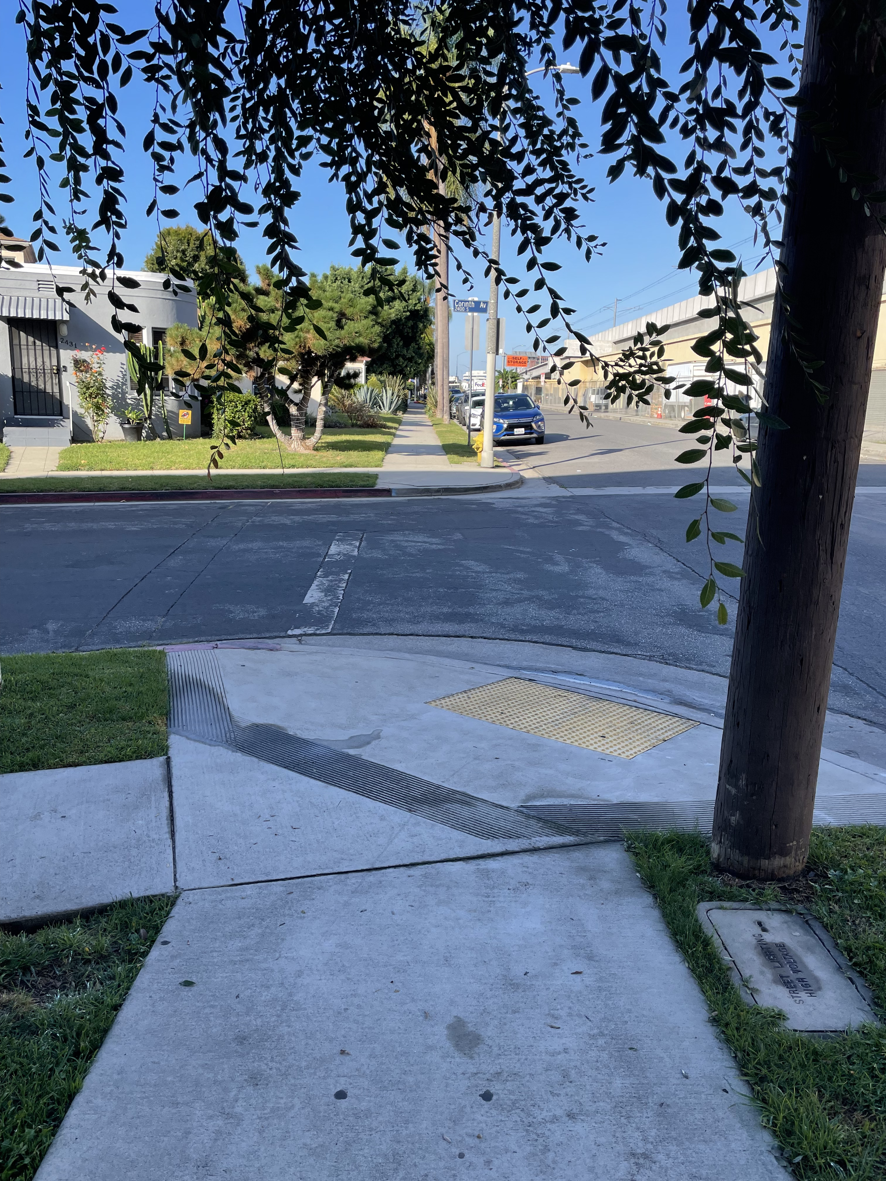
Unambiguously highway=crossing + crossing=unmarked (across a highway=residential). The sidewalk clearly disappears, and the pedestrian has to go into the asphalt roadway.
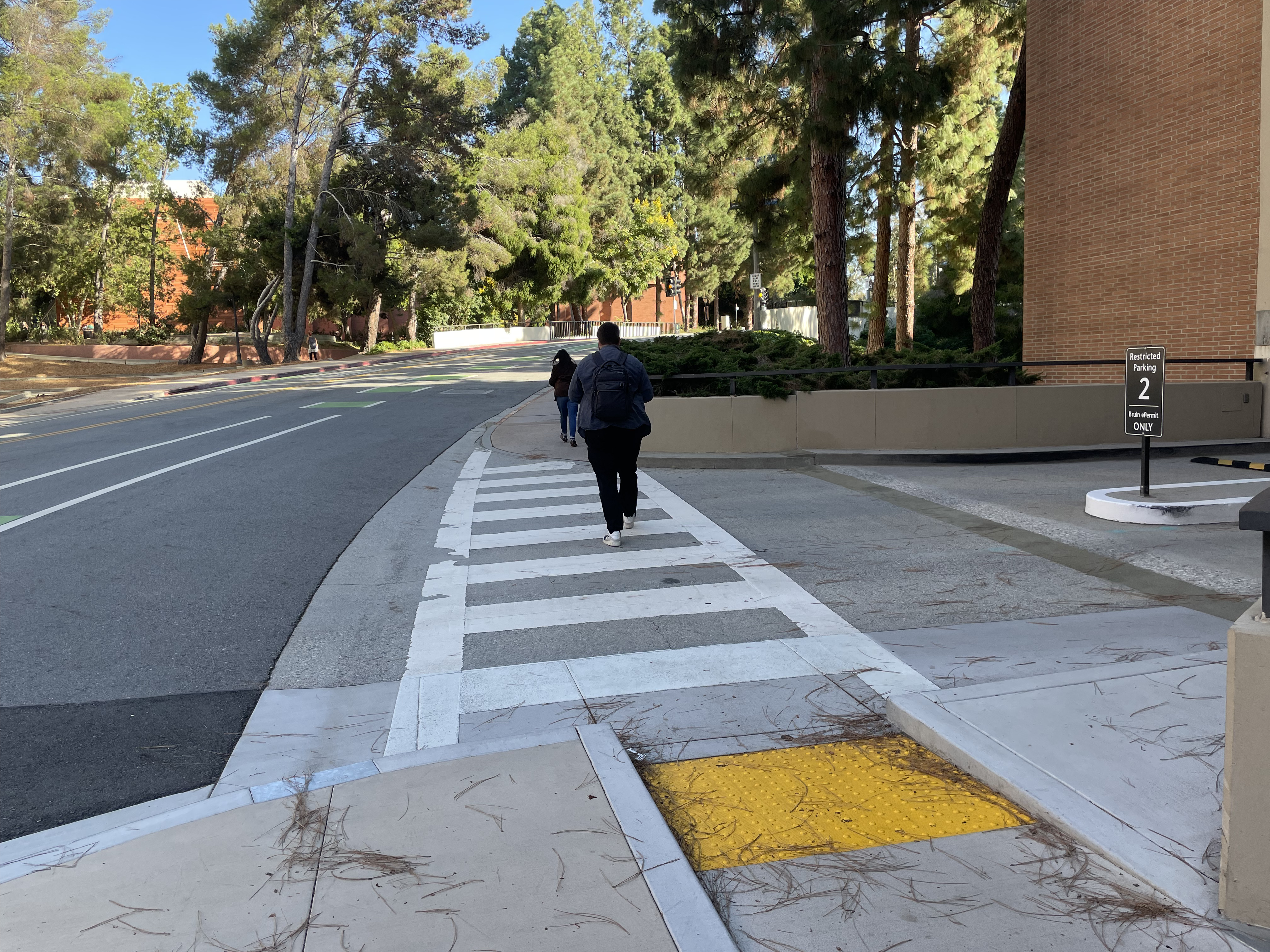
This is across a highway=service entrance to a parking garage to the right, but the sidewalk clearly dips to “road” level, evidenced by the curb cut. It’s currently tagged as highway=crossing + crossing=marked, though crossing=uncontrolled could conceivably also be tagged (I don’t particularly like crossing=uncontrolled, but my rant against it is probably off topic here)
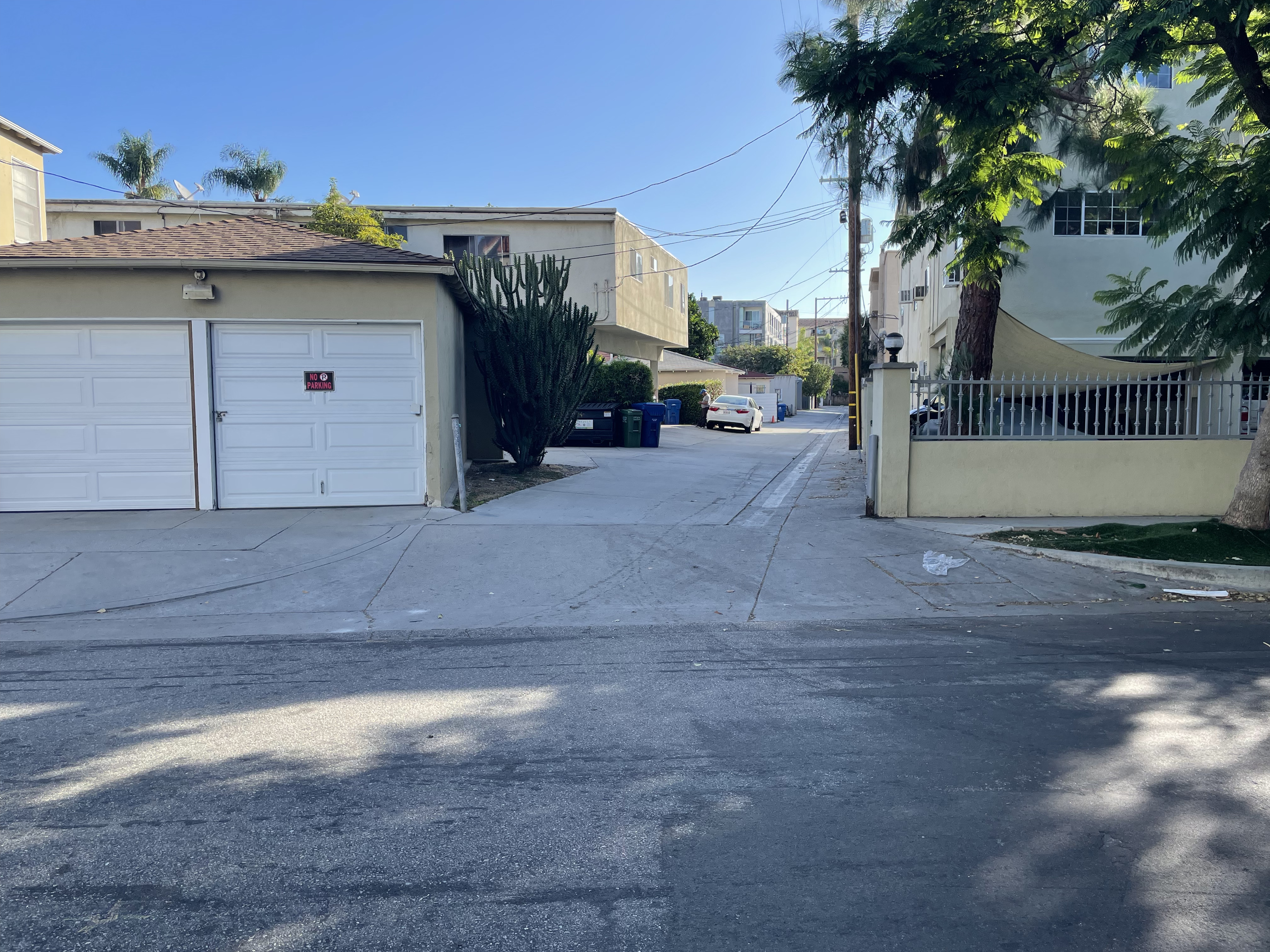
Across a public highway=service + service=alley. This one’s a little less clear: there’s a stenciled in flush curb, but the alley is at the same level and made of the same concrete surface as the sidewalk. In my mind, the sidewalk here isn’t really interrupted, but I could understand someone else interpreting this differently. Until the most recent post, I assume this was the case for which the new crossing=sidewalk was being advocated, but now I’m not totally sure. crossing=marked + crossing:markings=surface doesn’t seem quite right here either. I’d probably just map the intersection between the sidewalk and alleyway as a bare node TBH.
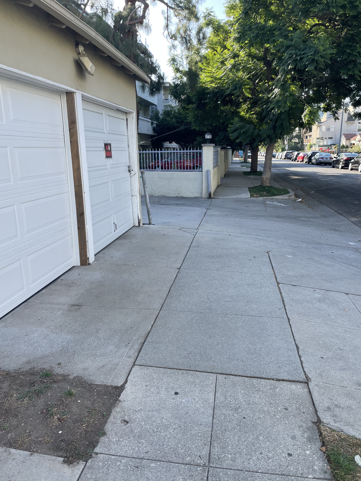
Across a highway=service leading to a parking lot for some businesses. Clearly to me here, the sidewalk is not interrupted, as it remains concrete despite the parking lot to the left being asphalt. It does dip a bit on the right side to accommodate the curb cut. I would leave this intersection as a bare node, which is how it’s currently mapped.
Interested in any thoughts on these examples with regards to the current topic!
Completely agree with your reasoning. The majority of driveways crossing a sidewalk look like the last 2 pictures. Because neither iD, nor SC asks for the type of these crossings, it’s simply assumed that they are “continuous sidewalks”. Oor maybe that there’s close to no traffic, so no reason to add this for routing purposes. Nice examples!
Do “stop” and “give way” signs apply to pedestrian traffic crossing thed road in the US? I’m asking, because in Germany, they don’t. “give way” and “stop” signs means you have to yield to other vehicles - not pedestrians. The only reason to put a stop sign there would be if any form of vehicle was allowed in the pedestrian zone, be it delivery or bicycles at certain hours. Interesting.
That’s also true in Nederland. Priority for pedestrians is granted by zebra stripes. (Not by fancy artwork striping on a slightly raised surface, though; that would amount to a table). That sais, the STOP signs do force traffic to stop first. In Nederland, I think they would paint a stretched out zebra, where vehicles can’t wait for the whole zebra to be clear of pedestrians, but have to find there way very slowly through the masses. I know a few places like that in Rotterdam. Sounds dangerous - but in fact it works like a charm: the pedestrian swarm moves itself around the slowly moving vehicles.
Having seen all arguments, I guess my preference would be to keep as close to the visual reality as possible and stay away from mapping implications.
Which means, to me (leaving private single-house driveways out of it at the moment):
Tag the intersection node as a crossing
Tag continuous_sidewalk=yes on the crossing node
Tag priority as indicated by whatever, be it signs or markings, but not at the intersection node.
Re 2: Or a comparable tag, saying that the sidewalk simply traverses the road. crossing=sidewalk would convey the information just as well, I think.
I guess 1 and 2 could also be tagged on the section of sidewalk traversing the road. Just the node seems more practical to me.
Re 3: In Nederland, this would be a kerb that the vehicles have to cross, possibly with explicit markings such as shark’s teeth at both sides of the sidewalk. The give_way would have to be tagged as nodes on the carriageway way, where it crosses the kerbs.
The situation where a kerbed pedestrian area traverses a vehicle carriageway where there is no cariageway junction, I would not map as a continuous sidewalk. It’s a way over a pedestrian area, I think, and the appropriate attributes would have to be tagged on this way.