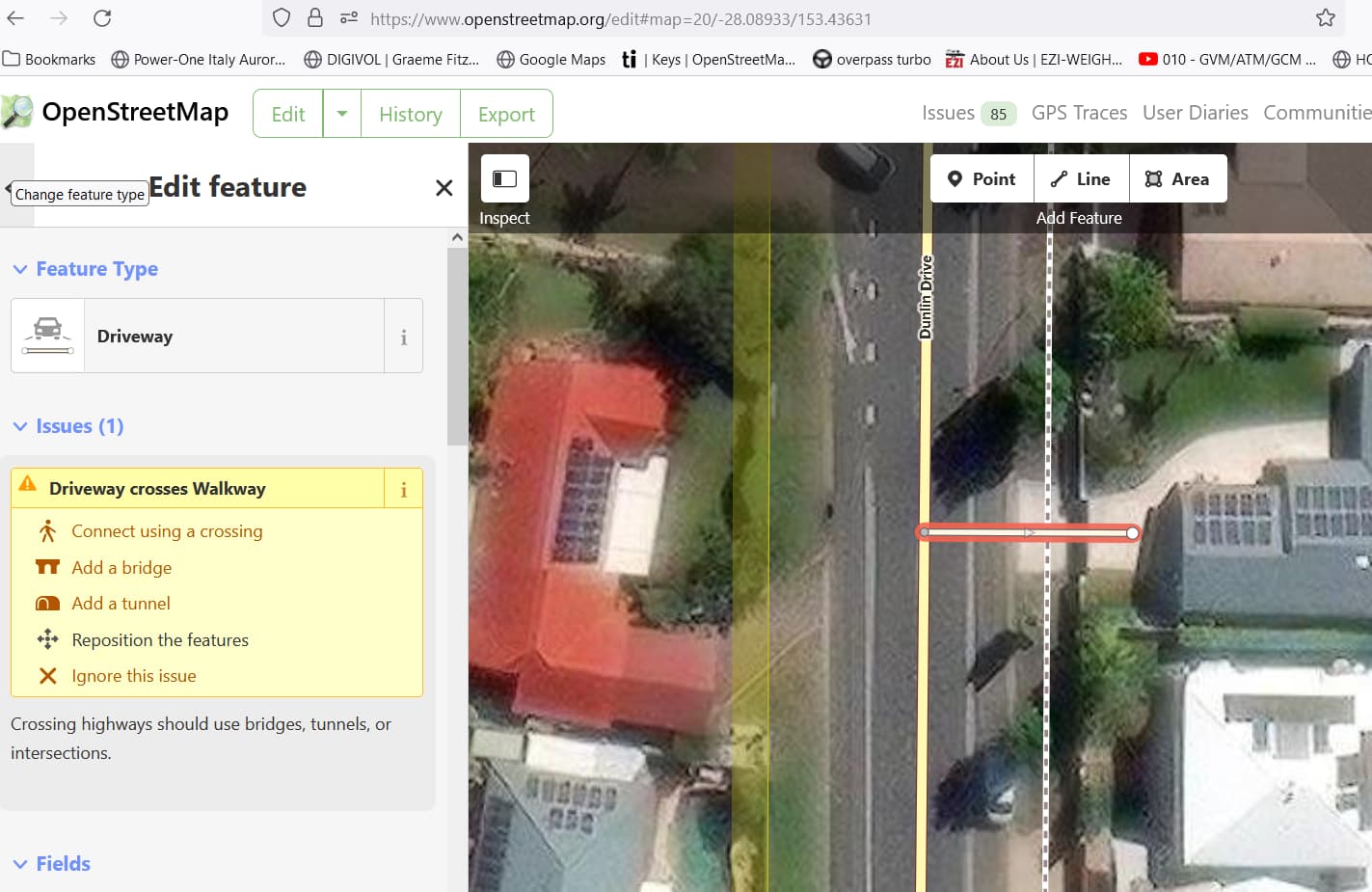
See how it can be quite subjective? ![]()
Is that why there is no highway=intersection, i.e. where both traffics are of the same kind, so an anonymous shared node is all it takes?
Probably because iD insists that they have to be added?
4 Likes
In this topic I notice that some/most/all contributors understand street or road as meaning the space reserved for motorized traffic. In my area, this is called the carriage way (Fahrbahn.)
Not anymore!
It looks like there are continuous footways with or without (flush) kerbs (for the pedestrians), with or without tactile pavings, with or without zebra markings, and with or without changes in the colour of the surface. Depending on the jurisdiction, they may or may not have legal implications such as pedestrian priority or traffic on the side road having to give way to traffic on the main road.
They all have in common that the design gives the visual impression that the sidewalk continues without interruption and it is the side road that is interrupted. This is instantly recognisable, verifiable and sufficiently different from anything we have an established tag for that it’s worth thinking about how to tag this!
The two tags that seem to be in use are crossing=pavement and continuous_sidewalk=yes. I wanted to learn more about how crossing=pavement has been used (it is about twice as popular) so I went looking for some examples on Overpass and Mapillary.
By far the most examples (708) are in the UK e.g. this one (Mapillary, OSM) and this one (Mapillary, OSM). The handful I’ve been able to quickly find pictures for are all continuous footways. I’m just going to message some users who have used the tag a lot in case they want to chime in.
There are also some uses in other countries. In France (38 uses) most examples I’ve found are simply crossings paved with setts such as this one (Mapillary, OSM). This seems to be a “false friend” (sett is pavé in French). Interestingly I also found an example in Australia (Mapillary, OSM) where it was used like this, and another one in the US (Mapillary, OSM). But in another example in the US, it’s a continuous footway (Mapillary, OSM).
If we accept that it’s a highway=crossing, is there anything wrong with using highway=crossing crossing=pavement?
1 Like
I would say, the road is crossed by an uninterrupted footway but it isn’t a sidewalk. I would probably just map this as highway=crossing crossing:markings=surface without inventing a new tag.
The sidewalk is tagged as a standard walkway (highway=footway). If you retag it as a sidewalk (footway=sidewalk) then there will be an additional option at the top to just connect the ways without tagging a crossing.
Shouldn’t that fix apply to all footways / cycleways / paths etc?
1 Like
Sounds reasonable to me and if it’s good enough for a pedestrian street, I’d say it’s good enough for a sidewalk too.
I was focused on mitigating the most unambiguously problematic usage. If a bike path crosses a service road, there’s more likely to be a crossing of some sort. A similar bare intersection option could be useful, but I didn’t want to create any user confusion by offering a choice in that case, since a false positive crossing is not as problematic as a missing crossing. Feel free to open an issue in the iD repository to consider a more intelligent way of presenting these choices to the user.
I’m not a native speaker, but isn’t pavement the British version of sidewalk? If we use footway=sidewalk instead of footway=pavement, wouldn’t crossing=sidewalk be more consistent?
Or is there more to it that non-native speakers don’t get ![]() ?
?
Also, according to my dictionary, pavement is an official engineering term and same as the british carriageway, which would completely confuse me. Can someone shed some light on this one?
1 Like
crossing:markings=surface doesn’t necessarily indicate the case you’ve brought up; quite the reverse in fact.
You’ll often find a crosswalk in a parking lot with no markings, only a surface treatment, where the walkway is still clearly interrupted by the parking lot road. A curb with tactile paving tells us that there’s still a significant risk to pedestrians from vehicles going past the crosswalk.

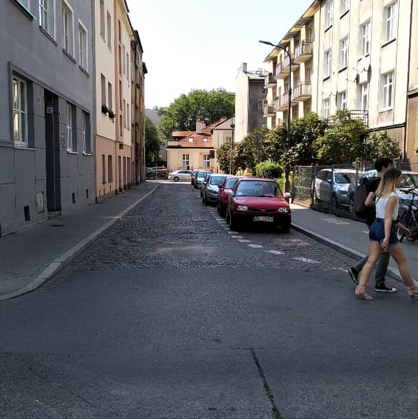
This can happen on the public road network too, especially at an intersection where an unmarked crossing wouldn’t be out of the ordinary:
")
In the U.S., surface treatment alone doesn’t constitute a legal crosswalk. In some jurisdictions, this means a crossing pedestrian who doesn’t yield to vehicular traffic would technically be jaywalking. Pedestrians don’t have to worry about this if the highway department makes sure to legally establish the crossing by some other means, such as placing it at an intersection rather than mid-block. But if they rely exclusively on the surface treatment, then it’s a safety hazard because both the driver and the pedestrian may think they have the right of way, when in reality only the driver does.
The crossing:markings proposal included a surface value not to contradict U.S. law, but rather as a concession to other jurisdictions where the law may differ. In those jurisdictions, tagging it as an unmarked crossing would be misleading.
Which type of traffic has the right of way would also be quite useful to record although it seems we don’t have a way to tag this yet.
this may be true somewhere or sometimes, but around here for the vast majority of crossings it is very clear who has the right of way: crossing=zebra / uncontrolled in many jurisdictions implies a right of way for crossing pedestrians, don‘t know about crossing=marked which just appeared without discussions about the intended meaning, crossing=traffic_signals means there’s a right of way for those with green light (typically), and crossing=unmarked means the legal situation is like at any other spot where you might want to cross the street (no specific crossing legally), i.e. it could be allowed or forbidden according to the local jurisdiction.
These few cases cover almost all crossings that are specified, curiosities like “toucan” don’t play any role outside the UK and in general are very few: https://taginfo.openstreetmap.org/keys/crossing#values
See how it can be quite subjective?
looking at markings and type of kerbs etc. like Nadjita suggested, makes it much less subjective.
Yes, “pavement” is the British term for a sidewalk. We use sidewalk in OSM largely because, in North American English, “pavement” refers to the roadway (carriageway, more or less) rather than the sidewalk. The two contradictory meanings would be a bit too confusing, sort of like “football”.
As I understand it, a crossing=unmarked is still a specifically designed or designated crossing like any other crossing, but with no markings (or rather no legally recognized markings, as in the case I explained above). crossing=unmarked doesn’t forbid pedestrians from going across; that’s crossing=no.
These tags don’t necessarily encode any additional meaning about right of way, but data consumers have always used heuristics to infer additional meaning from tags based on likely real-world scenarios. That seems to be what we’re concerned about: the assumptions we think data consumers will make with these tags. I don’t think a data consumer would assume that a highway=crossing has different right-of-way rules just because of crossing:markings=surface.
I’ve now looked at some of the 400+ times that the tag continuous_sidewalk=yes used. It usually appears on its own, without any additional detail. If you saw a continuous footway that had a flush kerb for pedestrians, tactile paving or zebra markings, how would you tag that? Would you add kerb=flush or tactile_paving=yes or even crossing:markings=zebra on the continuous_sidewalk=yes node, without adding highway=crossing?
What I like about staying within the realm of highway=crossing is that comes with all these established tagging conventions for these additional details. For example, it’s unambiguous that that kerb=* on a crossing is about to the kerb that people walking along the sidewalk might have to cross, not to cars driving over it.
In the UK, pedestrians at junctions always have priority when they are crossing the road, even when it is a crossing=unmarked. The continuous footway itself conveys no specific pedestrian priority, as they have priority anyway. So I think the legal implications differ across the world. Maybe a case for country-specific default values instead of tagging each node with information on who has to give way? And we just map what we see on the ground e.g. a continuous footway/cycleway or not.
If it has any form of kerb, especially with tactile paving, then it’s a traffic_calming=table for me. The absence of a kerb or change of surface is the important bit, so it’s perceived as a continuous sidewalk.
I would say quite the opposite: The kerb is on the highway crossing, not the one being crossed.
Are you saying that I can jaywalk anywhere and still have the right of way?
Like here:
In Germany, we distinguish between having “the right of way” (Vorfahrt) and having “priority” (Vorrang). Only vehicles can have right of way, pedestrians can only have priority. Priority usually only applies for traffic travelling on the same “axis”. For example, if you make a left turn, you have to wait for cars coming from the direction you would have gone to if you didn’t make a turn. They have priority, not the right of way. The same is for pedestrians: if a pedestrian crosses a road, then the cars going left and right of you have priority, but pedestrians have priority over cars making a turn. A zebra crossing gives pedestrians priority, not matter the direction in which they cross. Hope that makes sense. But anyway, it might not be that every country distinguishes like that…