Concerns about Azerbaijan

I recently did on-the-ground mapping in Azerbaijan, and I am concerned by the state of the map there. Most of the country has been mapped by a single individual: user MenKauRa. Unchallenged and without much experience globally, he has developed a very idiosyncratic way of tagging that has brought Azerbaijan away from the OSM standard:

  • The map is full of incorrect tags on POIs, like amenity=townhall for things that aren’t an amenity=townhall. When I complained in a changeset comment (139264998), MenKauRa replied that if the correct tag does not render on the apps he considers popular in Azerbaijan, he feels the need to add some other tag that will render. This is, of course, classic “tagging for the renderer”. As I mapped, I discovered more and more spurious tags used for these purposes.

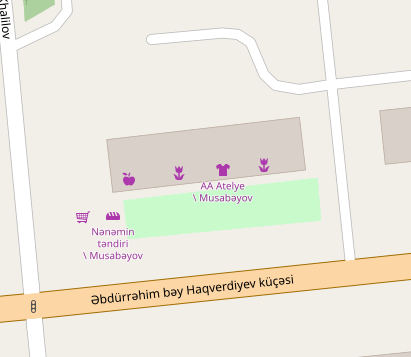
  • To the name= tags of POIs, MenKauRa has been adding, after a backslash, also the name of the town. In the same changeset discussion, he says that he feels it necessary to do this since some people’s apps might not find the POI otherwise. It seems to me that MenKauRa has simply reinvented, in a poorer form, the long-deprecated is_in:city tag. The result is that names of POIs in Azerbaijan look like nowhere else; they look like the result of a bad import. As an example, see the cafe at 40.1731, 49.4699 and the other POIs to the northwest of it: there is absolutely no reason to specify the town in the name= tag (moreover, many of these are generic names, not the POI’s actual name).

Frankly, this situation reminds of the case of Lithuania, where one power user insisted on some strange tagging before the Data Working Group had to get involved. But at least the Lithuania power user’s edits were always made with parseability in mind, so they were easy to find and fix, but I fear that undoing the damage in Azerbaijan will take considerable effort. I’m just a single mapper; how can the community come together to ask MenKauRa to stop mapping for the renderer? I would suggest an automated edit to remove backslash+place from name= tags, but this needs to be debated by the community. If there is a better place for this discussion than this section of the OSM Forum, please let me know.

5 Likes

Can you link the changeset where you discussed these topics with MenKauRa? It would be useful to understand and maybe address the situation.

I already mentioned the changeset number, but here is a link.

1 Like

Example of the backslash tagging:

image

(location)

I have also invited MenKauRa to join this discussion.

Hello CRCulver

  1. I don’t understand the very statement of claims to me, in part because (as you noted) “most of the country was drawn on the map by one person”… Are there any restrictions on this matter?
    I was born and live in Azerbaijan, I constantly travel around the regions of my country due to my work, and I know almost all the roads in my place. Do you think that I can’t often edit the map of my country? And who should edit it the most? A citizen of another country who has never been to Azerbaijan, for example you?.. Where is the logic?

  2. About “amenity=townhall”… Yes, mistakes were made on my part, and I began to correct them as much as possible. But there is a nuance - the concept of “amenity=townhall” in Azerbaijan is very different from the European approach to this tag. Unlike Europe and the USA, in Azerbaijan there are several bodies of city, district and rural administration and self-government - in one settlement there is a 1- city or village executive authority (Icra Hakimiyyeti), 2- city or village municipality (Belediyye), 3- city or village counsil (Kend Shurasi), 4- local representative of executive authority (Icra Numayendesi)… One town hall doesn’t end here, and only the tag “amenity=townhall” is applicable to all these bodies according to OSM tags. I do not think that the management of OSM will create new tags specifically for the administrative structure of Azerbaijan…
    I will repeat again - I will gradually correct the mistakes made. I already wrote to you about it. And I think you don’t need to remind me about it every time…

  3. Regarding the use of the sign " \ " in titles. If it’s honest, then I didn’t find any remarks in the rules of OSM about prohibiting the use of the sign " \ "… If you know such a point, then indicate it here. By what logic is the " \ " character unacceptable?
    I will give you a quote from one of my answers to a user who raised a similar “problem”:
    “I want to inform you that in most names of state, public and private institutions in Azerbaijan (including the names of ordinary cafes) there is also the name of the city, and sometimes the district… That’s why it is displayed on the board at the entrance to the institution… For example, “Press Distribution Center \ Khirdalan city \ Absheron District” (Press Distribution Center \ Khirdalan city \ Absheron District). … This is the specificity of names in Azerbaijan… For example, in Azerbaijan there are 26 villages with the name of Khajmaz in different districts, so usually the specific name of the district is added immediately after the name of the settlement…”

  4. I wish you to visit Azerbaijan, and use the existing OSM map instead. You will see that I am trying to edit a map for my country, which will be convenient for everyone, not only visitors, but also local residents(!).

With respect.

3 Likes

I’ve not followed OSM editing in Azerbaijan, but just saw this thread

That you have made such a proportionally large contribution to the OSM map of one country is something to be proud of, I think. And I’m sorry to understand that there are not many other Azeris contributing to the map of their country.

The way you describe this sounds very much like the organisation of administrative divisions in the Ottoman Empire (and probably inspired by that of Persia) that are reflected in the administrative divisions of Turkey and Bulgaria (where I live). There are town halls for municipalities (belediye in Turkey, obshtina in Bulgaria) and villages (mahalla in Turkey, kmetstvo in Bulgaria). Both are tagged with amenity=townhall in Bulgaria, but the municipal ones are additionally tagged with townhall:type=municipality and the village ones with townhall:type=village. Is this also applied in Azerbaijan?

It is generally a good idea to reflect the “on the ground” evidence on the map, but there are limits. This is described here. So not the whole content of the sign should be entered on the map, but only the part that can be considered the name. Any other information that can be given by other means, such as a symbol for the kind of amenity, its location, address, etc. should go into other tags. So “Press Distribution Center \ Khirdalan city \ Absheron District” should be mapped with a node or area with tags amenity=press_distrubution_center (or a more well documented tag that describes it best), addr:city=Khirdalan and addr:district=Absheron This is the international consensus for tagging such a place, and it would be best to apply it as much as possible all over the world so that map items mean approximately the same everywhere.

I hope to visit Azerbaijan in the future too (when land borders open for tourists) and use the OSM map that you contributed so much to. I hope it will be similar and as reliable or better than the OSM map of Bulgaria. :smiley:

7 Likes

Dear rhhs Richard.
Thank you for evaluating my work, understanding the nuances and wanting to help… I appreciate your opinion, and I think that the link you provided will be useful… I hope to use your comments, and I am sure that they will be useful to me in my work…
Regarding the closed land borders of Azerbaijan, as you know, the political situation in the region implies certain risks for the security of our country. This is a forced and temporary measure that the government has taken, given the proximity to Russia and Iran (and this is no secret), which may pose certain challenges to stability in Azerbaijan. At the same time, the air borders are always open, and the country is visited by quite a large number of tourists, businessmen, cultural workers, diplomats… There were almost 3 million visitors in 2023… Much more is expected this year, and international COP-29 conference will be held this year in Azerbaijan…
I hope that the situation will improve soon and you will be able to visit our country by land (especially since Bulgaria has always been and is one of the friendliest countries for Azerbaijan)…
Thank you again…
Sincerely…

Of course your efforts to map Azerbaijan are very admirable, MenKauRa. However, you keep mentioning “convenience of users”, and I believe that your attempts to provide convenience have resulted in tagging for the renderer, when in fact convenience is the responsibility of renderer developers and not us as mappers. Our task is to map on-the-ground facts, and during my time mapping Azerbaijan, I found innumerable instances where the tagging did not reflect facts on the ground.

Unlike Europe and the USA, in Azerbaijan there are several bodies of city, district and rural administration and self-government - in one settlement there is a 1- city or village executive authority (Icra Hakimiyyeti), 2- city or village municipality (Belediyye), 3- city or village counsil (Kend Shurasi), 4- local representative of executive authority (Icra Numayendesi)

While you believe that Azerbaijan is somehow special in this regard, such hierarchy of authority is common all over the world, and this can be mapped with careful use of office=government tags, with no need for very many amenity=townhall instances in a single area. However, as I found and as we discussed, you added amenity=townhall and other tags to unrelated things solely to get them to render on your preferred app, and this is not allowed.

For example, in Azerbaijan there are 26 villages with the name of Khajmaz in different districts, so usually the specific name of the district is added immediately after the name of the settlement…

Again, Azerbaijan is not at all unusual in this respect. All over the world, certain toponyms repeat again and again from one district to another. However, as mentioned by the user rhhs, there have already been, for many years, proper ways both to tag such toponyms, and for software to find toponyms by region. Instead of asking “Where do the rules say I can’t use a backslash?”, it is better to ask yourself “Why am I the only mapper in the world doing this?” I understand that you are fond of Azerbaijan as your home, but it is not a very special country as far as standard tagging goes.

Do you think that I can’t often edit the map of my country? And who should edit it the most? A citizen of another country who has never been to Azerbaijan, for example you?.. Where is the logic?

You are taking offense to a matter that is not meant as offensive. Nobody wants you to tag less. Rather, it would be better if Azerbaijan could attract a larger amount of users around you. However, through the history of OSM, the community has seen that a country being mapped by one power user can involve certain risks, and I started this discussion merely so that the community can alleviate those risks.

This also relates to a complaint i had to the DWG two months ago which I documented in this thread where that same user deleted hundreds of name tags.