Let me start out with maybe this is a coincidence and Google caught on to this from using their own users GPS while using their app, but seems like perfect timing.
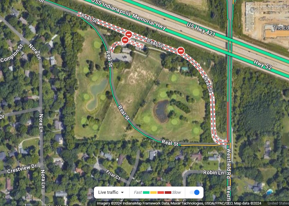
A newly reconfigured (basically completely newly constructed) street nearby was opened to traffic on December 19th, 2023. A few days ago (January 2nd 2024) I took a GPS trace of the new road and uploaded it to OSM and changed the road in OSM to follow this new route ( Changeset #145780066 ).
Google Maps as of January 2nd when I checked had not updated their maps for the new road and had still stated the old road was completely closed. Now as of today I checked and the new configuration is on Google Maps and (at least visually) lines up exactly with the GPS trace I uploaded.
Is this a crazy coincidence that less than 4 days after OSM got updated Google updated theirs? When ultimately they would have been receiving GPS traces from their own users since the road opened several weeks ago.
It’s more likely that a user at Google Maps “added” (technically “suggested”, as the edits have to get approved) the road, and possibly that user being the same user who added it in OpenStreetMap, thus why it follows the exact same line and not being for example less-curved.
It doesn’t line up that close when you overlay them. The lower curve has a noticeably larger radius and you curved upwards slightly on the straight portion approaching Westfield Road.
Google could have noticed that OSM updated and then independently chosen to update their map. This would be perfectly legal, but I doubt it’s what happened. With so many OSM users updating the map, Google will update the same area within the next few days some fraction of the time based on pure chance, and if we’re both trying to accurately map the world, the map will look similar.
They could have noticed that enough people using android phones traveled along a similar path. This could have trigger a check whether it as a new or existing route.
In the past I have noticed that areas where google maps is empty after I add details to OSM they appear in google maps sometime after. But have always assumed they keep an eye on OSM, but trace it themselves, never actually compared the traces.
From what I understand Google is technically able to copy our data. Even if that is not true, it really doesn’t change the status quo. Yes, I find it annoying that they might use our work to improve thier map. It is not something I am going to worry about as long as they don’t try to impede OSM in some way. Some problems are not worth solving.
Google can use our data if they follow our license. This would include attribution, and you can see in some areas Google uses OSM for bus routes, I believe. They do not use our data in most of the world.
Open Data doesn’t discriminate by field of endeavor, so there’s nothing special from the license side about Google using our data.
It would be really nice if the larger companies like Google, Mapbox, Tesla, etc… would partner and allow mappers to look at larger anonymous data sets to help improve the maps even faster. Get closer to the levels of detail of HD maps being used in vehicles today.