Hi,
I am living in Dubai and working for some years in my free time on corrections and additions to the Dubai map. This is proving to be a challenging task, because there are lots of new things coming up all the time as everyone living here can agree on. ![]()
When I was today mapping and reviewing an area that I am moving to in the next weeks, I found a very inconsistent quality of metro stations in Dubai.
While reading up a bit on those stations, I encountered some things that were unclear to me - I am hoping that someone can help me here to find a best practice to map these stations.
Someone has already put the effort in putting in all the lines and stations - however the station buildings are really looking different and I am uncertain what attributes they should have.
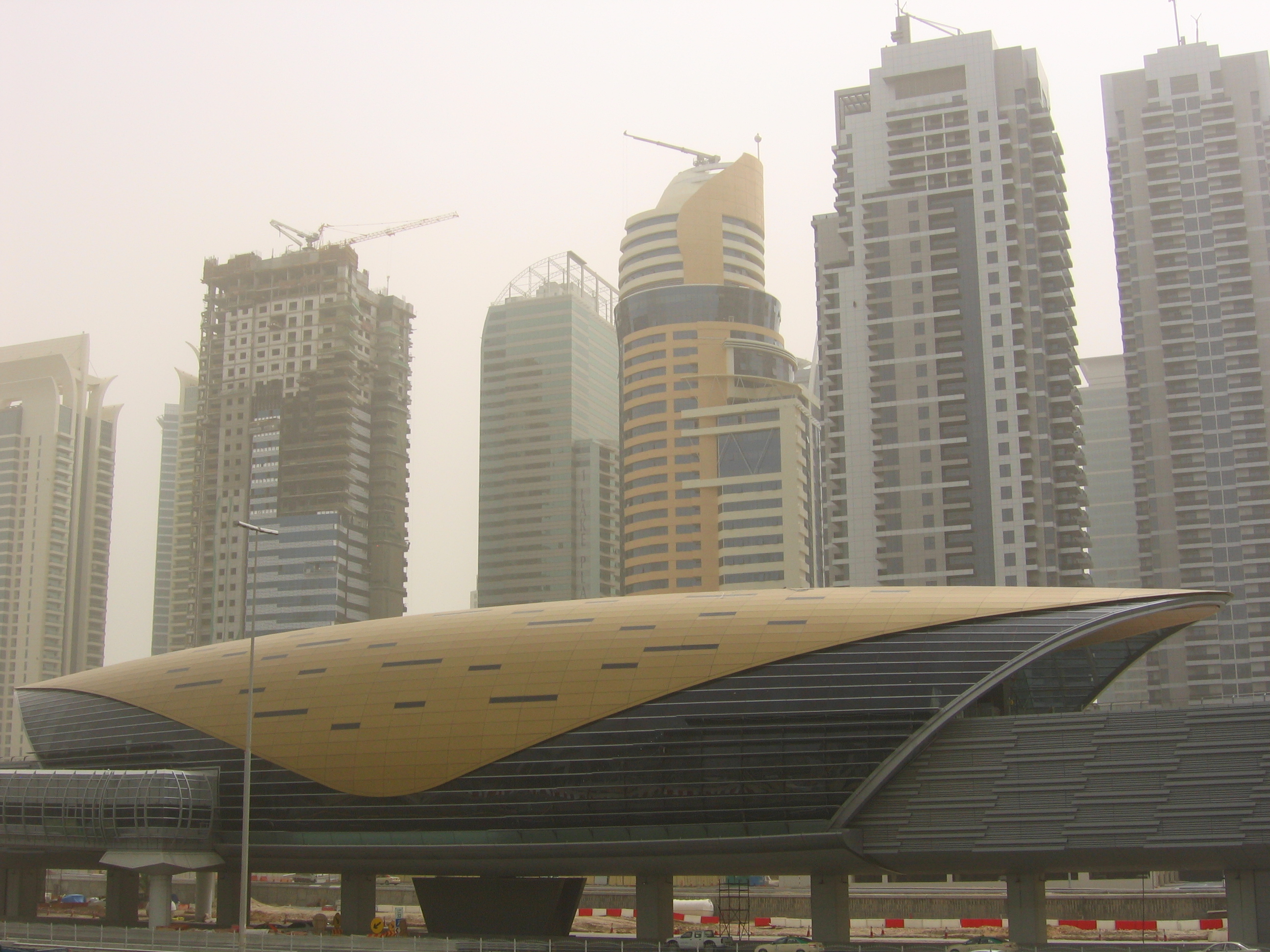
I would propose we take Al Jadaf station as an example. Al Jadaf can be found here: 25.22493,55.33388 http://www.openstreetmap.org/search?query=25.22493%2C55.33388#map=18/25.22493/55.33388.
In general in Dubai, there are just two kinds of stations, the ones overground and the ones underground. For now, I would like to focus on the overground stations first.
The overground stations all look (mostly) the same. This is a great example of a station: 
I have been following the railway station article on the wiki: http://wiki.openstreetmap.org/wiki/Tag:railway%3Dstation. Especially the diagram on what should be named how is very helpful, but does not fit 100% onto the existing metro stations here.
Now, here come my questions:
- I have several components in the metro station in OSM right now:
-
A node that sits on the track with following attributes
- construction = yes - I assume this is not true anymore, as it would indicate the station is still under construction
- name = Al Jadaf - name of the station in the metro system
- name:ar = الجداف - Arabic name in the metro system
- railway = station - This is feeling like not being in line with the wiki article from above. Shouldn’t this be related to some point not connected to the track directly? I am referring to this again in the second part of my questions.
- station = subway - I do not get this attribute at all. I can see that this is recommended in the “Metros” article in the OSM wiki, bit it goes against the rules mentioned in the article on railway stations.
-
A building that has following tags:
- building = yes - it is a building, however the recommendation is to call it building = train_station
- name = Al Jadaf Metro Station - I am not sure this is correct now. We already gave the name before, does the name have to be on this also?
-
A walkway that leads away from this station on both sides with following tags
- bridge = yes - is this correct?
- highway = footway - this makes sense in my opinion
- layer = 1 - this is above roads (if there are roads leading underneath, see picture of a metro station above)
-
Some stairs, an escalator and an elevator leading down to the ground. For now they have the following tags:
- highway = steps
Could someone give me their feedback on the existing tags and created types of nodes and ways? I am always hesitant to remove tags, as someone else has put effort into this already.
- According to the railway station wiki entry, a larger number of additional nodes should be required. I am not sure all of those apply here in Dubai. Your thoughts would be appreciated.
- Platforms: I do not feel that platforms make sense here. The typically two platforms are both inside the building and kind of hidden. I am not sure this provides additional value to anyone. This includes information on references etc. mentioned in the wiki article on railway stations.
- A node holding information on the station name etc NOT sitting on the track. Not sure what to think about that one. I would first need feedback on the point raised in question 1.
- A node showing the stop position of the train. This is the same as the platforms. I feel it is a bit of nonsense to add this, just too much details in a way too small station.
- An area covering the platforms and building, giving the name of the station again. In my opinion this is the same as the building if we are hiding the platforms inside, correct?
- The whole landuse = railway areas… Again this is not done in Dubai right now. Does this make sense? The metro is usually on a viaduct or underground.
- Could you maybe point me in a direction of an example of how metro stations are tagged in some other areas of the world? Which one would you consider the “cleanest” with regards to tags etc? Maybe I would be able to use that example then and apply it to the Dubai Metro…
Thank you in advance and sorry for the wall of text.
Veit