Changes to the USA / Canada border at the southern end of Alaska

Hello, Andy from the DWG here.
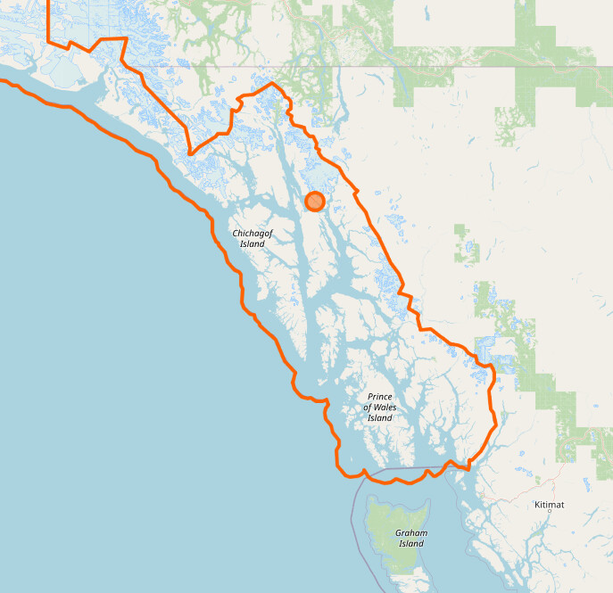
We’ve received a report of a problematic edit to the area known as the Dixon Entrance , here.

What seems to have happened is that a relatively new non-local mapper has tried to “fix” the border here (because the USA and Canada borders didn’t align, presumably due to the dispute that the Wikipedia link mentions).

The affected relations were the USA, Alaska, and two lower-level Alaska relations, Ketchikan Gateway and Unorganized Borough. The last two relations were actually broken in the process and have since been restored by another mapper.

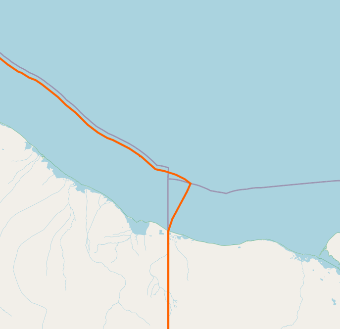
The net result seems to be:

USA before
USA this morning
Alaska before
Alaska this morning
(those examples look different before and after)

Ketchikan Gateway before
Ketchikan Gateway after
Unorganized Borough before
Unorganized Borough after
(those examples look OK now, but may still need checking)

The relevant changesets seem to be 128606318, 128607009, 128607218, 128607350, 128608035 and 128608075.

Note that there are node and way changes made in those changesets too. A “simple revert” isn’t an option, because among other things some of the relations concerned have had valid edits since.

Assuming that the changes made by this mapper do need to be undone, does anyone fancy having a go? It’d need to be someone with some experience of editing large relations, of course. If not I’m sure that we (the DWG) can, but we being non-local to Alaska/Canada there may be things (like the node and way edits) that we’re unfamiliar with.

Best Regards,
Andy

I’ll also mention this on talk-ca, talk-us and OSM-US Slack, but it made sense to try and have the discussion in one place to which everyone has access.

5 Likes

I’m not really sure what the proper resolution to this issue is. The boundaries in this area are not all in alignment, so some further cleanup would make sense. However since the US and Canada claim different maritime boundary lines here I’m not sure where the optimal line in OSM should be. This paper on Canada’s Unresolved Maritime Boundaries explain the situation pretty well.

My preference would probably be to draw a line splitting the difference between the two claims and tag it as an indefinite boundary somehow.

We could also tag both claims and have the two countries overlap a bit, with the relevant ways being marked as disputed using one of the tagging systems for disputed boundaries.

1 Like

I’m inclined to restore each country’s portion of the border from the latest respective government sources. I’m pretty sure I know how to do that for the US, does anyone know where there’s a license-compatible version of Canada’s international boundary?

1 Like

I think that Canada’s claim is what’s in OSM already, so that probably doesn’t need changing. The only relations that were changed by the problem edits were USA ones. Changing it back this way has a couple of things going for it:

  • Despite the overlap, it’s a revert to the “status quo ante”, which is always a good place to start from.
  • Having small overlaps like this is pretty much the normal way to handle this sort of small dispute.
2 Likes

I’m looking at the data now and this will be no problem. I also see that NOAA has re-surveyed the maritime claim and it’s a tiny bit different from what’s in OSM, so I’ll upload the new geometry along the Alaskan coast at the same time.

Apparently there are no less than 5 disputed boundary sections:

I’m planning to tackle only two of them, the Dixon Entrance and the Beaufort Sea disputes, since it’s one continuous section of geometry that I’m working with for the Alaska boundary.

1 Like

Completed in changesets:

The Alaska panhandle now overlaps the Canadian claim:

Similar overlap in the Arctic for the other disputed claim:

Note the difference in geometry is reflecting the new NOAA boundary data (US federal government public domain).

I also fixed all adjoined boundaries that were impacted by this edit (hopefully), including several timezone boundaries, which is the reason for such large bounding boxes.

I was unable to edit the maritime boundary around the island that sits at the International Date Line because of a limitation in JOSM, so that ring remains unchanged.

2 Likes

Nice work @ZeLonewolf! When I was working on the East Coast EEG, I saw that the pacific coast line was not in there.

Thanks!

In case anyone needs to link to it in the future, those relations immediately afterwards are 148838 1116270 2605248 7939736.

Just totally, wow. Those 4 (thanks for linking, Andy) are things of beauty. They almost go “pop” on my screen! (They look that good). I tip my hat, sir.