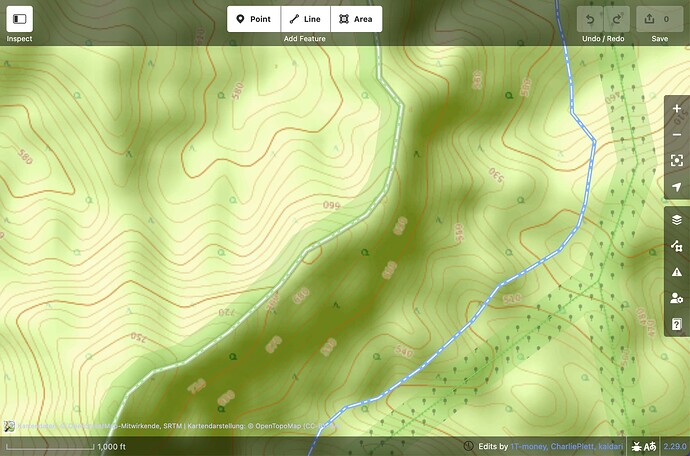
As you can see in the above screenshot of OpenStreetMap (map=16/16.7424/-88.7575), the southern portion of the Administrative Boundary for the Cayo District and Stann Creek District in Belize (blue line) is apparently offset by about 2000 ft from where it should be. It should follow the top of the mountain ridge, as the Nature Reserve Boundary (green line) does. Only a portion of the boundary is offset, but it’s a large enough portion that I can’t fix it in the web editor or JOSM. Can someone with more map editing skills take a look at it? (Also, can I safely assume that the boundary is what is offset from reality and not the OpenTopoMap layer?)
It would be much easier and overall better to just reuse the existing (green) national park boundary lines (e.g. way 61981296) as the administrative boundary of the districts, and then delete the misaligned blue line. That would require some adjustments around the end points, but nothing beyond capabilities of iD or JOSM.
Deleting long ways in iD is a pain, since the editor won’t let you do that in one go. As a workaround,
- split the way in screen-sized chunks and delete those, or
- Delete object nodes by holding Del for extended time (the process slows down as the deletion progresses).
Those boundaries were last edited by @CharliePlett so you may approach them and synchronize the effort
Last year, a mapper placed the boundary on the “green line” (top of the mountain ridge, the Nature Reserve Boundary):
https://overpass-api.de/achavi/?changeset=145509085
But a few months later, another mapper entered a new boundary with the offset:
https://overpass-api.de/achavi/?changeset=148550411
I don’t know the reasons. Perhaps you could contact them?
That’s how it was last year. This would essentially be a revert of the recent changes.
The best action is that you ask the mapper (CharliePlett) directly in a changeset comment of your own at Changeset: 148550411 | OpenStreetMap . Since I pinged him above, and he also has a forum account, he might also reply here.
If you’re reading the way history correctly (I did not delve into it) I suspect it was an import from a source with a different offset or different projection, which does look wrong. But let him explain and/or revert himself first.
Charlie is fairly active in the international group at telegram. I’ll drop him a line. I believe him to be the person to talk to when talking about anything OSM in Belize
Charlie here, so the issue is that the forest boundary data comes from ProtectedPlanet and the district boundary comes from another online source. The forest reserve seems to be correct as it follows a mountain range, but If I apply the district boundary to the forest reserve boundary then I would have to modify the district boundary which I don’t know if it’s a big no no to edit district boundaries. So I need advice from you guys what’s the best way to go about it.
Not knowing any better, I went ahead and started fixing the district boundary a couple days ago just because it was really bad, e.g. the border going east from Big Falls instead of south and putting Mahogany Heights mostly in Cayo (it should be entirely in Belize District), etc. But then I got to this part of the border where it traces the mountain range and it was suddenly very detailed and accurate, but offset. I’m very much a newbie at map editing and I think I got in over my head. I hope you and the other more experienced mappers can help clean it up. The legal definition of the Cayo District boundaries can be found on Wikipedia. There’s also a low-res but official map of the electoral divisions at https://elections.gov.bz/wp-content/uploads/2023/12/2005-August-Electoral-Divisons-Map.pdf. That should help for sanity-checking ambiguous areas, like where the southern border of Cayo meets Guatemala, which is difficult to figure out.
I actually got the district boundaries from an electoral shape file. I mapped all electorals and put the district boundaries to that. But as you pointed out, that Wikipedia article seems to say that the boundary should follow the stream.
And BTW, I have an OpenStreetMap Belize group on Telegram if you have any questions for me. I could also answer any other mapping related questions that you might have. Or you can contact me through the OSM Website.
So anyways, I have now applied the district boundary on to the forest boundary.
