This surprises me greatly because OSM tagging is known for its consistency!
14 Likes
Oh, if it were up to me, I would probably render it, however, does anybody know why those exceptions were made?
Not really. Nobody can understand the reasoning given on github, because in tons of other cases the same reasoning would apply but the decision was different. At the moment, the Carto Cabal just doesn’t want to give in. Ever.
2 Likes
I am not asking about Carto. I am asking about the wiki (see above for link) - why short stretches of road exclusively used by buses are not included under highway=bus?
See “rationale” in the original proposal
https://wiki.openstreetmap.org/wiki/Proposal:Tag:highway%3Dbusway
My understanding is that busway was intended to fill a perceived gap in the overall transport infrastructure tagging, for infrastructure related to BRT systems. I suspect it makes intuitive sense if you live in a city where BRT is a key part of the infrastructure, including several large South American cities. Short bus roads connecting to depots and so on were already covered by highway=service.
I think this brings us back to the “duck tagging or not” discussions referred to on several other threads recently. Is highway=cycleway for any random bit of path that a government decides to stick a blue bicycle sign on, or for actual cycleway infrastructure? Is highway=busway for any random piece of road reserved for buses, or for actual BRT corridors? (Perhaps brt_way would have led to clearer duck tagging but the proposers might have been told off for inventing English words).
7 Likes
Yeah, sounds more reasonable. I was missing this thread however: Highway=busway on non-BRTs
Has this STILL not been sorted out yet?!?
3 Likes
If it bothers you, use a different map.
The state of the OSM Carto project** is what it is, and is unlikely to change any time soon
One of the maps on osm.org shows busways pretty clearly, and there are plently of other osm-based maps that also do.
** from an organisational perspective.
1 Like
The Americana map style currently renders busways. Welcome aboard!
7 Likes
I know how to use different maps.
That’s not the problem.
The problem is that the majority of people don’t know how to use different maps, they just see the default one. If the default one is crap, they think OSM is crap. If most people in the world think OSM is crap, it will likely die in unfunded squalor. For the good of the project, it behoves problems with Carto to be sorted out promptly. Either that or boot Carto off being the default on www.openstreetmap.org ![]()
8 Likes
A post in a remarkably similar thread to this one (that you and I have both posted in!) lays out what would need to happen. As that post concludes - It’s a social and organisational problem, not a technical one.
2 Likes
Yeah I knew I’d been on threads moaning about this previous - hence me saying ‘is this STILL not sorted out?’ ![]()
So are our mechanisms to effect social & organisational changes up to the job?
I’ve no idea, but I do do know I certainly don’t have the bandwidth to do it without dropping something else. How about you?
I don’t think I have any contact with OSM’s social & organisational change mechanisms at all - I just edit the maps ![]() (and occasionally post on here when I get a bit stuck
(and occasionally post on here when I get a bit stuck ![]() )
)
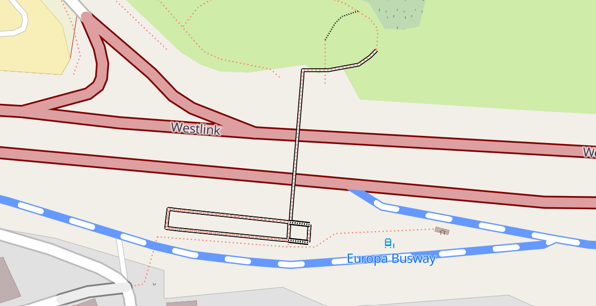
Yesterday I was editing a literal busway in Belfast that is even called ‘Europa Busway’ on the signs and bus stops. And Carto renders it as an empty space ![]()
AFAIK no an noone else is interested in running project to create such map style
at least not enough to actually do this
therefore current situation has not changed
1 Like
Yeah that’s fine. But I take it the maintainers of Carto want to continue to be OSM’s default renderer? Who controls the switch that currently makes them the default?
1 Like
See the post that I mentioned earlier - that sets out a process that is likely to work. Once someone has set up a team and established credibility with the rest of the project (perhaps by creating a rendering somewhere that ticks all the boxes that OSM Carto doesn’t) I’d start lobbying the OSMF board (and the people who look after the website) directly about a switch.
4 Likes
(This is a personal response and not on behalf of the EWG)
The foundation have (through the Engineering Working Group) been paying to develop a vector layer that provides the immediate response that OSM-carto currently provides, and style issues have been allowed to take a back seat to the effort to put a sound technology stack into place. This work is now approaching fruition. Be prepared that rendering choices will need to be tweaked and that we will need to build healthy style governance for the front page, which we have lacked for a while.
3 Likes
(apologies for veering off the busway and onto the verge)
Firstly - thanks for that - I’ve used it!
What is the plan with regard to the schema used for an OSMF vector tile layer? I appreciate that what we have is a proof of concept around a well-known but fairly light data schema, but it currently doesn’t include anything like the breadth of OSM data that even OSM Carto knows about**.
Is the plan to engage with someone to develop a vector schema that better matches (a) what’s in OSM Carto and (b) what people have most frequently outlined as being missing? Are there any timescales around that?
** However, although the schema is not documented as doing so, the OSMF-hosted vector tiles do know about busways.
8 Likes