I would like to know how to block a road for cars so OpenStreetMap directions maker doesn’t propose itineraries on this road anymore.
There is a fence at that position, so I’ve created a way with barrier=fence tag, and I’ve connected that way with the road I want to block. Still, OpenStreetMap continues to make directions through that road.
Could someone please indicate me what I’ve missed ? I’ve just begun mapping 1 week ago :')
In order for the fence to actually affect the road, you have to add the barrier=fence to the node they share as well. And then, you’ll have to wait some days, because the routers don’t immediately pick up all the new data.
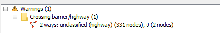
The oddity , at least with JOSM is, if you draw a fence across a road without connecting, the validator indicates the road is being crossed by a barrier.
Always interpreted this as OK, must be blocking traffic. Then when you connect the fence with the road, no warnings as if no obstacle exists, so indeed, it’s tagging the crossing node with something.
Never tried waiting for OSM Inspector for doing it’s daily round and see if it fulminates or not the next day, but a block does. Another oddity is a gate, set on a road node and nothing else. Traffic is fine until one adds the locked tag or private. That’ OSM Inspector will cause a red flag for routing.
I have no idea when barrier=fence on node would be valid
every time you map that there’s a fence at a point rather than drawing a line. I would not recommend it, but I think it isn’t ambiguous or invalid either
My understanding was that the car park is closed off by a fence, so the driveway ends in front of a (temporary?) fence, and not a gate. But who knows :o)
It’s actually just as, or even more, important to map the new, correct, entrance first!
It doesn’t have to be perfect, just a best attempt, with a Fix-me added “Please update alignment when imagery available” or similar.
Than as Mateusz said ^, mark the old entrance road as disused & access=no, tgether with a description something like “Entrance permanently closed June 2025. New entrance 100m South-East”
Yes, this is the right way to block traffic. Simply drawing a fence across a road (whether connected by a node or not) is just drawing a fence (similarly with barrier=gate). Somewhere there needs to be explicit access tags blocking access.