Beach Emergency Numbers in Western Australia

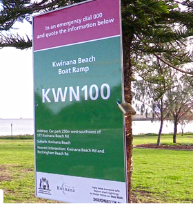
Beach Emergency Numbers (BENs) are managed by the West Aus state government. BENs are shown on signs at beaches, the idea being that when calling for emergency assistance you can quickly and accurately provide your location. These numbers have been successful in improving emergency response since their introduction 5 or 6 years ago.

The signs look like this:

Screenshot from 2024-12-12 10-58-35

The WA Government does publish the location and values of the BENs. The license is Creative Commons Attribution 4.0.

These are the numbers in my region:

My first question is, should these signs & BENs be mapped?

I imagine that a poorly maintained representation of emergency information could be worse than none at all.

If so, how ought they to be mapped?

I assume as a single node but I’m not sure what tags might be appropriate.

Finally, is there any scope to import the locations and data?

I understand there are many reasons to be reluctant to import data, including licensing and accuracy.

The first step would be to contact the dataset owner to see if they will agree to the waiver OSM requires to use CC-BY 4.0. See this LWG post for more information.

Tag:highway=emergency_access_point - OpenStreetMap Wiki is a tag that seems to match this

There is also the alternative emergency access point

https://wiki.openstreetmap.org/wiki/Tag:emergency%3Daccess_point

A personal contact to the BEN coordinator would be a good start. If they are agreeable then they may be able to assist with getting the required waiver

image

Awesome. I’m unreasonably excited that the answer is not an outright “no”.

I will indeed contact the custodian.

emergency=access_point seems reasonably suitable

I’ve mapped a few of these locally, and it looks like others have too at least around Perth: overpass turbo

The highway=emergency_access_point tag seems to be more common than emergency=access_point.

That very much depends on where you are

https://taghistory.raifer.tech/?#***/highway/emergency_access_point&***/emergency/access_point

I have manually mapped many of these signs (as highway=emergency_access_point).
If you look at https://catalogue.data.wa.gov.au/dataset/beach-emergency-numbers-ben-signage this data is licensed for use under Creative Commons Attribution 4.0.
Does this mean it can be imported?
If so, who can do this (I’ve no idea where to start - and it sounds scary)

I meant specifically in Western Australia. Or do you mean it varies across the state?

Not unless there’s a waiver signed and recorded on the wiki: Australian Data Sources - OpenStreetMap Wiki

I’ve reached out to the data custodian asking for explicit permission to use this data, by way of the signed waiver.

Thus far I haven’t received any response but it was around the holiday period and I do have some other avenues with which to follow up.

1 Like