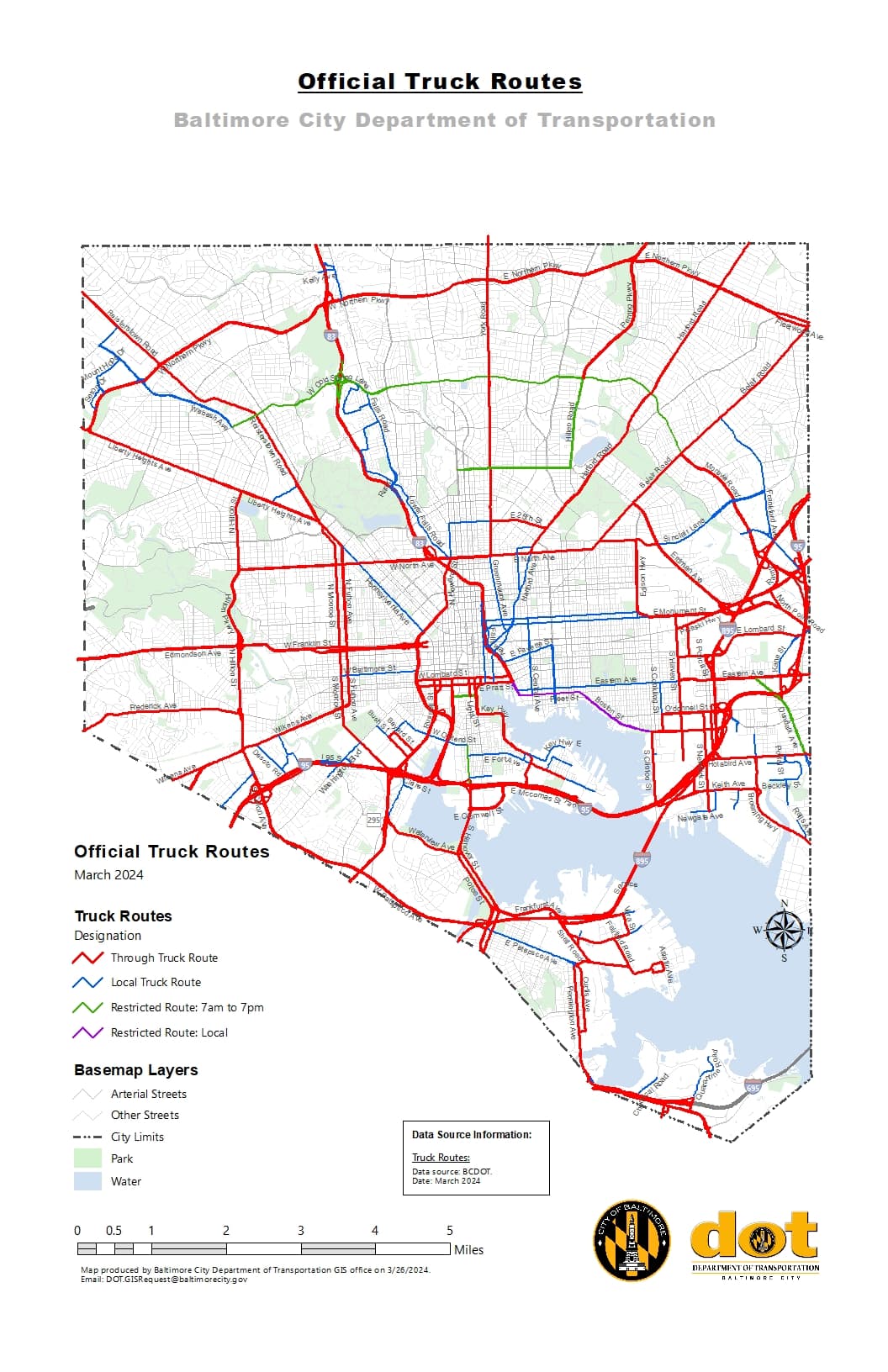
If anyone is interested in helping out the Baltimore disaster response to the Key Bridge collapse, please consider updating truck restrictions on roads based on this map from the city. The map was released yesterday to other mapping providers to enhance their truck data.
Update: I’ve asked and received permission for this BCDOT data to be used in OSM via Discord (how cool that the local DOT is highly active on Discord…)
Here’s an except of our conversation. Maryland’s open data act provides the necessary license cover for OSM.
talllguy — Today at 1:35 PM
Question about the truck route data you provided in the Waze channel. Would you allow people to update OpenStreetMap based on the data and the map? In the past I’d sought and received permission to use (at the time) MOIT data within OSM to improve buildings and address mapping throughout the city. Truck data would be great to have in OSM as many companies that do routing analysis draw from it.
BmoreCityDOT — Today at 1:35 PM
Please do. I can get you a GIS file.
talllguy — Today at 1:36 PM
I saw the file in the Discord, thanks! the shapefile
Thank you very much
Are there any hazmat=designated routes that should be set as part of this, for that matter? (I ask because the Key Bridge was a designated hazmat detour for the tunnels)
The local truck routes in NYC are tagged with hgv=local (overpass-ultra.us). I was under the impression “destination” implied that the element with the tag was the destination, while local routes are roads that trucks should stay on when they leave the main routes but not necessarily the destination themselves. Could be over thinking it though and they may have just been tagged =local many years ago.
In US road sign terminology it means “No Thru Traffic” (motor_vehicle=destination), “No Thru Trucks” (hgv=destination), or similar. So traffic headed for a destination along the road, or on a side road is allowed, but not traffic that is passing through.
This does sound like something different than hgv=destination if they are routes trucks should stay on, not routes through trucks should stay off. Sounds like this is the same meaning as hgv=designated then. Just a route designated for trucks.
“Through Truck Route” means a designated route trucks are directed to take through The City of Baltimore with unrestricted access twenty-four hours a day
hgv=designated
“Local Truck Route” means a designated route to move a truck from a through truck route to a destination based on delivery schedule or bill of lading.
hgv=destination then, since this is a “No Thru Truck” route.
“Restricted Truck Route” means a designated route has specific truck restrictions for hours of movement from 7pm to 7am
Thanks for finding this information. These three tags lineup precisely to my understanding of how these work. The map does show a fourth restriction that appears to be a duplicate of the local restriction. I’ve asked the DOT what the difference is, but it is probably just a GIS issue.
Good question about designated routes For hazardous materials. The rest of the beltway, I 695, All the way around the city is a designated hazmat route and has been touted on the local news quite a bit in light of the collapse.
Both tunnels look to have hazmat=no Which is sufficient, however there are some more specific limitations within that. I’m not sure how much of that is useful and has an accepted tag, but I’m usually of the opinion that the more the merrier in terms of the level of detail that can be put into the map.
895 tunnel
… vehicles in excess of 13 feet, 6 inches, in height, or 96 inches (8 feet) in width; and all double trailers are prohibited from using the Baltimore Harbor Tunnel
95 tunnel
No moves over 11 feet wide, 14 feet 6 inches high, 85 feet long, and/or 55 tons permitted .
I’m not sure this is working in terms of routing. Since *=destination will be only used if you can reach your destination on such a route. If not all the highways=* in that area have such a tag, that tagging will result in the opposite routing behaviour. Routers will avoid those routes.
So actually hgv=local would be a better fit, just not sure the term is a good fit. Something like a main-destination-road, where all the not highlighted roads should have hgv=destination.
I don’t know that the destination value’s scope has ever been clearly defined. My impression is that some routing engines behave as though a destination edge requires the route to begin or end on that edge, whereas other routing engines consider all the adjacent destination edges together. The latter is definitely true of routers that treat private as a sort of destination, returning a route from your current location even if you’re trapped inside a gated, private neighborhood. This is the only way that we’d be able to model some kinds of restrictions, for example when a town declares all its streets off-limits to through traffic, or an entire network of highways and streets around an airport is for airport traffic only.
Though in both cases the router will not accept destination-ways in the middle of the route and usually prefer no restrictions over destination-restrictions. Which is resulting in, the routers will guide the truck via untagged roads rather than those intended to be used and now getting tagged as hgv=destination.
But I’m with you, the OSM-concept in this regards is pretty fishy Current concept is more suitable for single routing-edges and less for guidance through larger areas.
Some of these local distinctions probably align with something like hgv=designatedhgv:national_network=yes versus hgv=designatedhgv:national_network=terminal_access versus hgv=designatedhgv:state_network=yes, but I don’t have the relevant National Network maps handy to confirm.