Hi Swedish OSM Community!
I hope everyone is doing great!
I have a question regarding Arlanda Airport. It seems like the construction at the airport is completed but the ways used for routing are outdated. For wayID 4967304 it seems like the One Way tag needs to be corrected.
For wayid 4967010, is this way correct? Should it be bi-directional and should it still be access=no? We have heard from our drivers that this specific way is able to be used to access the Terminal 5 car park, but I would like some extra confirmation from the local community ![]()
Thanks in advance!
Keep well ![]()
Kevin (From Bolt)
2 Likes
I hadn’t even spotted it was in the wrong category - I have moved it.
1 Like
Thank you to mods for moving the topic, and thank you to Bolt for asking.
This type of question requires someone to have updated on-the-ground information about the current state of the roads outside the airport. Without such knowledge, you likely know as much as, or more than us what the situation there looks like. If pictures or first hand information from someone there could be provided it would be a simple task to update the roads - but without it, it would just be guesswork.
If you can obtain such data (pictures or other detailed descriptions) from your drivers we could fix it in minutes. Just post it here if you’ve got it.
1 Like
Hey!
Thank you so much for your feedback! I’ll be reaching out to some of our drivers to see if the can provide us with some hard evidence to make the corrections to the map! I’ll keep you updated!
Hey!
We got some confirmation from the Parkman at Arlanda. Red dots are the routes for Taxi to T5 and Yellow dots are the routes to T2. I know the evidence provided is not great, but do you think it will be enough to update the routes leading to T2 & T5?
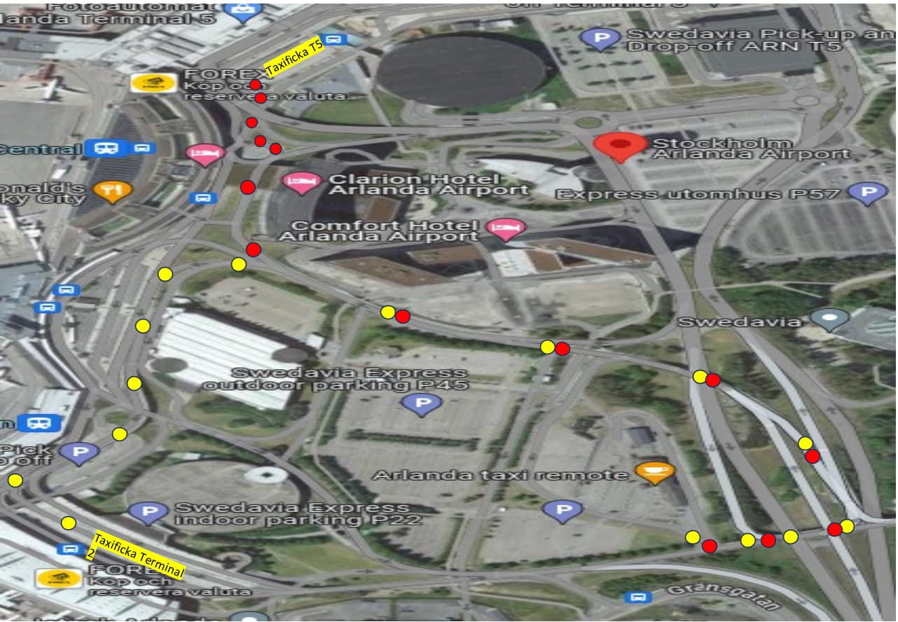
So its “follow the dots” ![]()
Presumably this:
So the wish is for these pathings to be routable?
The imagery provided is presumably Google (not allowed to map by in OSM).
We have access to Bing, Esri and Lantmäteriet photos in this case. They all show the same road network.
Lantmäteriet:
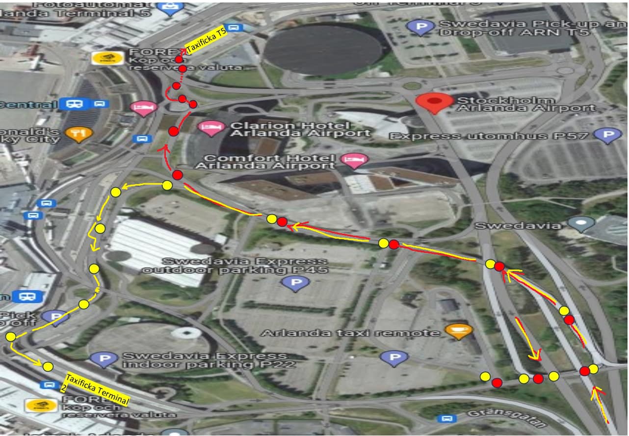
I translated the dotted picture to this:
I assume that you are looking for ACCESS (not egress) routes, so based on that, and the dots I’ve identified two problems (marked on the image):
A) One-way restrictions. You can’t enter the taxi area from this direction, Also tagged access=no, psv=yes. This is the kind of place where we really want some proof before changing directions on the road, but this picture seems to indicate that two-way driving is possible here:
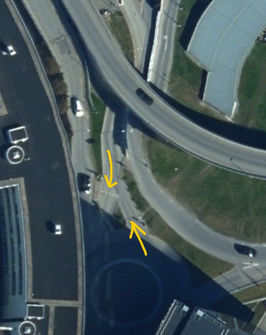
B) The ramp leading to the bridge towards the southern terminal (Way: Arlandaleden (104244469) | OpenStreetMap) is tagged plainly access=no. Apparently nobody can use this ramp ![]()
Are we narrowing in on the problems here? Notably, the way (Way: 4967304 | OpenStreetMap) you mentioned in the first post does not match with any of the dots. The resolution of the bridge is probably dependent on the status of the construction.
The construction stopped the counter-clockwise flow and made the routes bi-directional. Presumably, if the construction is finished, all traffic has returned to the large counter-clockwise pattern.
Thanks for your detailed feedback and apologies for the format that the Parkman sent his dots in ![]()
For Point A I do agree 100%. Let me see if the Parkman contact can provide a photo or any other form of evidence to lift the restrictions and change the direction of traffic flow.
For Point B, I also noticed the bridge is also inaccessible, but there are also other issues there with the attribution of bus lanes ![]() Way 490587422 is a bus route and it makes the other ways after it completely inaccessible for private cars.
Way 490587422 is a bus route and it makes the other ways after it completely inaccessible for private cars.
I will reach out again to the Parkman and ask if he can provide solid photographic evidence or a video file that we can use in order to update all things related to Arlanda! I’ll get back to you as soon as I hear anything!
If you can find a person with excellent on-the-ground knowledge, a video call would be super effective rather than sending a bunch of photos. The best thing would be to have some kind of representative from Arlanda tell us what is what.
We have reached out to the Parkman again, I’ll get back to you as soon as I hear anything!
1 Like
Hey!
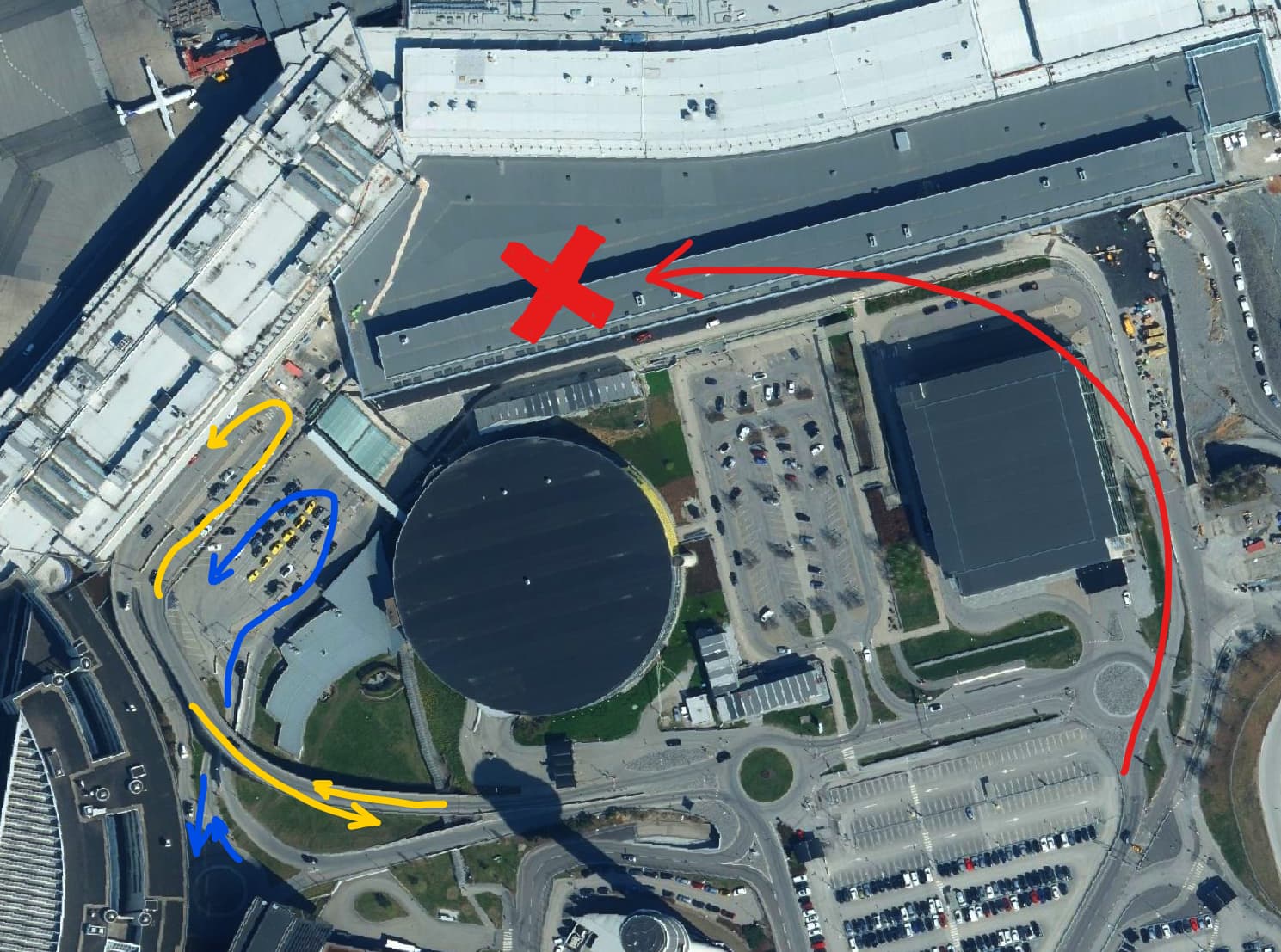
We finally have some footage to share. Here is the latest Mapillary footage that was taken on Monday.
The footage was only for the road leading up to T5, the route for taxi cannot be followed with a private car.
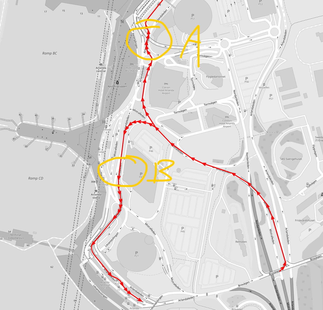
Ok, @Bolt030 sadly the photo sequence stopped just as it was getting interesting. Anyway, I was able to make a few updates around the roundabout, and in the surrounding areas:
https://overpass-api.de/achavi/?changeset=145074792
Hopefully, this will fix the immediate problem. on that terminal.
I stumbled across this airport for a different reason recently.
The gates are tagged as building=gate. This tag is undocumented and ambiguous: for example, the Brandenburg gate uses the same tag. Does an experienced airport mapper have a better suggestion?
(The same tag is used at Heathrow airport)
Hey @Wulfmorn ! Happy belated new year!
Thank you for everything you have done to help with T5. Its a new year and there is a new problem ![]()
For Terminal 2 there are similar issues that were present for Terminal 5, random edges with having access = no On Mapillary you can see that there is a boom gate that is not for private cars, the problem is we don’t know the exact extent of this restriction as no private car can go there. My question is, can we make road updates with the limited information that we can see from Mapillary?
Update:
We reached out to the Parkman and they have given some written confirmation of how things work at Terminal 2.
Hej där, och god fortsättning!
Övre planet är endast för taxi med Swedavias avtal och transponder, för upphämtning och avlämning.
Nedre planet för privata fordon, upphämtning och avlämning.
Upphämtning sker genom passage av en infartsbom in till taxifickan, efter att fordonet blivit framkallad till terminal från taxiremoten.
Uppställning av fordon sker direkt till vänster efter passering av infartsbommen.
För avlämning, följ skyltningen. Sväng 1:a vänster uppe på bron, och kör ca 100 meter till ytan för avlämning.
Yes, you can edit OSM. Editing access rights should be pretty straightforward. It’s more difficult if there are several layers of road on top of each other.
I’m not even close to Arlanda and I’ve barely ever been there - so you are in a much better position to make good edits than I am ![]()
2 Likes