Hello,
Andy from OSM’s Data Working Group here. Someone has mentioned to us that Strava activities completed in this area are recorded as being in “Snowdonia National Park, Wales” . They believe that, following the recent renaming (see here), in English it should be something like “Eyri National Park”. See e.g. the park’s English website. OSM is I believe correct with it’s name, name:en and alt_name:en tags.
Strava’s maps come via Mapbox, but it’s unclear from the screenshots of Strava’s UI that I’ve seen whether the icorrect name is:
An area defined in Strava itself
An area imported via Mapbox, and Mapbox is perhaps using very old OSM data
Something user-defined created by a (different) Strava user
The DWG’s correspondent did of course try raising the issue with Strava’s support people, but despite a quite detailed explanation from the person pointing out the error, communication with the Strava person did not occur; they only replied “I recommend reaching out to [OpenStreetMap] directly, https://www.openstreetmap.org/help”.
If anyone has any contacts within Strava that might be able to respond in a slightly more helpful manner please email data@openstreetmap.org with a subject line of “[Ticket#2023080910000121] Strava and osm mismatch of place names”.
Hello.
As a user of various MapBox services I can contribute the following=
Strava uses a MapBox basemap.
Contacting Strava to report a MapBox issue would not be very effective.
MapBox map styles are constantly updated, this includes the OSM data used in their styles.
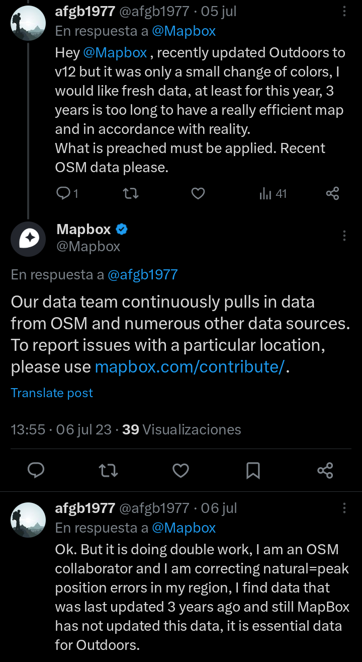
MapBox have a serious unsupported problem with OSM data updates, a couple of weeks ago I indicated an error similar to the one reported in this thread and their response was not satisfactory for me.
The problem that occurs is detected more easily by OSM mappers than by regular MapBox clients.
Basically=
MapBox is just integrating new data into their map styles. Existing data corrections (position, elevation, name,…) have no effect on MapBox map styles.
I just did a full review and fix of all the natural=peak nodes in my state and added several that weren’t in OSM. The revision and correction included the change of position, elevation and spelling of the names.
I was very surprised when finding the new natural=peak just created together with the old natural=peak with the same errors as before the correction
Determined to find out what was going on, I did tests with other types of nodes. Unfortunately I found a lot of inaccuracies like:
My own edits of natural=peak that didn’t update.
Nodes removed several years ago from OSM that are still present in MapBox.
Nodes with editions from 2 years ago where position and name were corrected, and in MapBox it presents the same errors before the mentioned correction.
I have not tested with highway=* but I suspect that I will find the same errors from the nodes (wp).
P.S. When you write to MapBox they will reply that:
“Our data team continuously pulls in data from OSM and numerous other data sources. To report issues with a particular location, please use Improve this Map”
P.S.2. I wrote MapBox a couple of emails a few weeks ago and still haven’t heard back, so I contacted them on twitter. (I know it’s not the right channel but at least they responded there).
Just updating this (sorry I forgot to earlier). At the back end of August the DWG’s correspondent said that the data had been “miraculously updated”, so things did work out OK after all.