Administrative level of townships in Maine

Thanks, everyone.

Based on this discussion, I’ve made the following edits:

  • Added wikidata QIDs to all Maine boundaries that lacked them
  • Changed all admin_level=9 administrative boundaries to 8.
3 Likes

Looks like you also created missing Wikidata items about the townships, which is great – but there seems to have been a technical issue with overquoting:

(Also, use lowercase aggressively in descriptions.)

1 Like

I created township of Maine (Q124157082) for you to use in located in the administrative territorial entity (P131) statements instead of unincorporated community in the United States (Q17343829), which is a kind of populated place. Hopefully this will result in fewer flagged issues. I also created unorganized territory (Q124157233) for the census-designated unorganized territories, not just for Maine, so you can add located in statistical territorial entity (P8138) statements.

1 Like

That’s perfect, I actually grabbed that township of Maine QID just now for a quickstatement and didn’t even realize you had just made it :grinning:

1 Like

I have updated Maine and Vermont table entries for both United States admin level - OpenStreetMap Wiki and United States/Boundaries - OpenStreetMap Wiki , though New Hampshire’s table entries could still use a bit of wiki love. We weren’t especially clear (here) about how New Hampshire differs by denoting the exact values we should be using for border_type=* in that state (or if we did, I missed it), so if “locals” could do that (here), I’d be happy to hammer in the last few finishing nails to both wiki.

It might go without saying that these wiki might be getting a little ahead of our tagging, being (for these three states) a bit more prescriptive rather than descriptive, but as I understand things, Brian and Zeke and maybe others are doing the updates in our map data (thank you to all who do). How “prescriptive vs. descriptive” our wiki are (or could be) is often an ongoing “chase” of “wiki chases map data chases wiki chases map data chases wiki…”, so, no big surprise here. We’re OK, especially as we communicate amongst ourselves.

1 Like

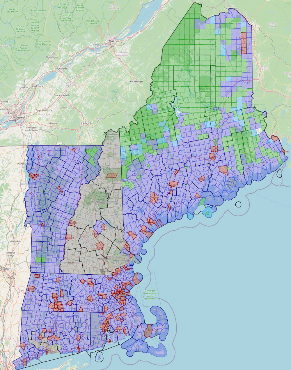
I’ve finished adding appropriate border_type values to all Vermont Towns and made this Overpass visualization showing the different types across New England.

Link to query: overpass turbo

Blue is (incorporated) towns and red is cities. Green is unorganized towns, townships, & gores. Grey is boundaries not yet tagged with border_type. Teal is plantations, but since these are currently tagged border_type=township I’ve just matched names ending in “Plantation”. This may not be all of them. I think it makes sense to change these to border_type=plantation.

I’m planning to add border_type across New Hampshire next, but I’m not sure how specific to get with values for the unorganized areas. They go by several different names (township, grant, purchase, location), but I don’t know if it really makes sense to have four different values for these relatively obscure, unorganized administrative areas. Similarly, it may not really make sense to differentiate between gores and unorganized towns in Vermont. As far as I can tell they are functionally the same, and “gore” is just a reminder of how they came to be. What do you all think about using the same border_type value for all of these unorganized administrative areas across VT, NH, and ME? “Unorganized township” seems a reasonable descriptor whether a particular area is called a township, unorganized town, gore, grant, purchase, or location.

1 Like

So these are really just stylized names for a single kind of administrative subdivision, in the same way that towns and cities in California are the exact same thing in every respect, other than what the local charter calls the place? Do people ever speak of “grants” and “purchases” as plural common nouns to specifically refer to the places by those names?

I’m not sure it matters a great deal whether or not we unify the terminology across states. Personally, I would probably ignore cross-state concerns in favor of whatever would make for a decent categorization of administrative subdivisions within a given state.

On the one hand, we’re currently tagging Louisiana’s parishes as border_type=county, recognizing that a civil parish there is equivalent to a county elsewhere. It simplifies some queries, but tagging them as parish wouldn’t be a big deal either, since the boundary=administrative keeps them from being confused with ecclesiastical parishes. On the other hand, I think it would be reasonable to tag Wisconsin’s towns as border_type=town even though they function much more like Michigan townships than New England towns.

If we really care about these values being state-agnostic, we’d tag all the counties as county-equivalent and all the Midwestern townships and Wisconsin towns as minor_civil_division or something similarly clinical. But border_type is a far cry from a universal or even a national ontology.

That is the sense I get, yes. For Vermont I can’t find any evidence that Glastenbury is administered any differently than Buels Gore. One of them just has a name that ends in “Gore” and the other doesn’t. Same with New Hampshire. Erving’s Grant, Wentworth Location, Chandler’s Purchase, and Kilkenny all seem to be the same type of unorganized administrative subdivision. The words gore, grant, location, and purchase seem to only indicate something about the history of these places, not current administration. I could be wrong, but my research hasn’t turned up a difference so far.

I can’t say I have good answer to this. Maybe? Maybe not? Probably depends. Warner’s Grant is generally included as one of Vermont’s four gores despite its name ending in Grant, and Wikipedia says “some sources list it as Warner’s Gore”. Hart’s Location in New Hampshire still has “Location” in the name despite being an incorporated town.

Agreed. If there were three different terms (one per state) I’d say just go with that. But across the three states there are six terms in use, and five of them (unorganized town, gore, grant, purchase, location) each apply to only a very small number of areas. Vermont has just four gores, and five unorganized towns. New Hampshire has more, but they are split between four different terms. Maine has a small number of gores. Across all three states, the vast majority of these unorganized areas are the Maine townships (aka unorganized townships).

Mainly it’s just not clear to me that distinguishing between grant, purchase, location, and township in New Hampshire really matters. And if that doesn’t matter, then the distinction between what the three different states call these places probably doesn’t matter either. So we might as well simplify things.

I don’t want to sound contrary, as it is clear that there is “rich distinction” in these three states, AND we are taking care to capture these distinctions, but I’d tend AWAY from simplification. OSM can (already) rightly pride ourselves on a tagging tradition of “what is” rather than “what things appear to be” or “what the locals call it despite that is really is something else” or even “what we agreed to semantically flatten them into” — let’s not do that.

I (one person) would prefer that if there are six terms, but “only five” each apply to only a very small number of areas, that rather than simplify, we retain the actual nomenclature. I wouldn’t have a problem with what that nomenclature means being well-documented (say, in our wiki — in fact, I’d almost insist upon it, and we are well down the road of doing this in many cases).

Really pretty graphic of the work done so far!

If others feel New Hampshire’s unorganized administrative subdivisions should be tagged one of border_type=township, border_type=purchase, border_type=grant, or border_type=location rather than a single value, I have no problem with that. I do think they are all the same kind of entity, but it’s easy enough to match on all four tags. If folks feel differently in the future they can always be consolidated.

It looks like these unorganized townships are all currently tagged admin_level=9 (example). I’ll plan on changing these to level 8 (to match the same change in Maine) unless anyone disagrees.

2 Likes

As a long time NH resident, I’d keep it simple and just use a single border_type. The proposed border_types “purchase”, “grant” or “location” are part of the name and are tied to their history. Functionally they’re the same thing, adding types doesn’t add value in my view.

Colloquially, I have heard some people use grants or purchases when they really mean unincorporated areas. In my experience, that’s more common with native-born locals who are long time residents. The new(er) residents I know tend to refer to refer to them as Unincorporated Places or Unincorporated Towns.

Which I suspect is influenced by how they’re referenced in NH state law: https://www.gencourt.state.nh.us/rsa/html/NHTOC/NHTOC-III.htm and more locally, the wording used by Coos County: Unincorporated Places | Coos County NH

3 Likes

Local perspective appreciated! I think as long as we document that such “simplification” or “grouping” (depending on how you look at it and wish to simplify or expand) I think we’re OK to simplify to a single border_type.

If (more-local-than-me) people could look at United States admin level - OpenStreetMap Wiki and United States/Boundaries - OpenStreetMap Wiki and see if the table entries for these three states are correct, mostly-correct / need small tweaks, or just-plain-wrong, please either say so here (and I’ll transcribe into these wiki) or please fix up the wiki directly yourself. Or, offer a thumbs-up that they are correct now, but I don’t think all three states perfectly reflect what we’re saying here. As is obvious in the first wiki, footnotes are OK! Thanks in advance.

With our good, open communication, timely editing / updating of our data, and especially local perspective on “the right thing(s) to do,” this (admin_level tweaking) seems to be working pretty well.

Edit: If something is really distinguished as a township or a gore or something specific, and OSM uses border_type to denote exactly what those things are, OSM should continue to hew to that. Otherwise, we devolve into (in some cases) “older people call it what it is, but younger people group these together like this” in a way where we don’t know what anything is any longer. The answer is “it is both a [township, gore…] (in this state, we say that is an 8) AND it is unincorporated.” We have tables in our wiki where we fit the pieces together in a (sane, if only slightly crazy) manner, but we manage to do that fairly well, as best we can. Because we sort of talk it to death, but we do make sure we agree along the way.

I also agree that all unincorporated places in NH should share the same border_type. There are some distinctions between different unincorporated places (do they run their own elections or not), but those distinctions are not reflected in the place name.

To recap, focusing on New Hampshire for a moment, it appears we have not yet reached consensus on this point. @Mapiate says these should be “kept simple (as) a single border_type” while Zeke and I (any others?) feel that since we use border_type to denote a “border type,” that any sort of semantic flattening (simplification) would be an exception that breaks this rule. I hope I’m getting that right, Zeke, I don’t want to put words in anybody’s mouth.

Saying (as @Mapiate does) that “functionally, (different border_type) values are the same thing” is like saying “in all 50 states, counties are the same thing, so we should call Louisiana’s parishes and Alaska’s divisions the same thing, as they function similarly.” No, they aren’t, and no, we shouldn’t.

Again, OSM can be proud that we so carefully denote these subtle differences (in USA’s admin_level and border_type tagging). While it isn’t saying much to utter this, I know of no other map in existence that is so careful to make these distinctions. Indeed, the Census Bureau does this sort of semantic flattening (every five years as they recategorize everything) when they toss things into a bucket called “county equivalent.” Let them, but let OSM continue to keep in sharp focus these subtle yet distinct differences. As Zeke says, “it’s easy enough to match on all four tags.” If you are “in” (working with data of) New Hampshire, it is simply a fact for you to be aware of that “there are four of these things, with four different names, that behave similarly or even identically, but they are called different things for historical reasons — oh yeah, there IS that reality.” It’s OK that colloquially (thanks for the links, David) in New Hampshire (citizens and state court websites) these are referred to by “vernacular groupings.” And OSM should denote this. But we do this in our wiki as a short blurb in a table entry, where people know to do this conflation, not in our data, where we would be conflating / flattening in a way that hides the truth from data seekers.

Otherwise, we devolve into a patchwork of “well, in New England (or any specific state), you simply must KNOW that we conflated four values into one single colloquial vernacular term.” Let’s keep such information in our table, accessible to all, and similar data exist for the whole of the USA, as they should. I’d rather not “play favorites” (for New Hampshire, or any state) by making such an exception.

I was under the impression, and this may be HIGHLY simplistic on my part, that border_type was really about what a boundary was called. And so border_type=city means it’s called a city even if it’s low population and border_type=town is because it’s called a town, even if it’s larger than some cities and so forth. It seems like just tagging them what they’re called is the easiest way to do this?

2 Likes

Brian, I’ll say “By George, I think you’ve GOT it!”

Let admin_level describe what OSM means by admin_level. Let border_type denote a border_type (what it is called as a type of border). Any categorization can (and should!) happen in our table, that’s what it is for, that’s what it does.

Nope, I don’t have strong feelings on this at all. I want to be able to distinguish unorganized towns from organized towns that’s all I really care about. If there are four values for unorganized towns I can union those all together, if there is one value that works just as well.

OK, you are talking about your particular use case, where it is less important to make the distinction under certain circumstances.

I’m talking about how to keep the data consistent for everyone, where we have established particular meanings for particular taggings, and asking that we maintain that consistency.

Zeke and I can certainly peacefully and harmoniously co-exist if we keep all four tags. David, by conflating, makes an exception to our consistency. Again, I’d rather we not do that, as “oops, there goes the neighborhood.”

Look, it’s 100% fine that we have such “local quirks.” It’s wonderful, in fact, and wonderful that OSM can denote these. We’ve established methods to do this, although having plastic tagging has allowed some squishiness to creep in at times. I think I’m simply advocating “status quo tagging” by my stated preferences here.

I think this makes for a good rule of thumb. I would only draw the line at legal fictions like Indian Hill, Ohio, which styles itself as a “village” but is a city for all intents and purposes. It would be included in any list of cities in the state and omitted from any list of villages, despite having changed the official name to “The City of The Village of Indian Hill” (capitalized exactly thus). By contrast, in California, there’s no practical difference between a city and a town, so adopting “town” in the name is the same as becoming a town in that state.

1 Like

Our wiki table reflects this with the usual admonishment about mentioning both “City” and “Town” in a California context, which is “synonymous by law.” See, I think we can (continue to) do this: put categorizations in the table (explaining the esoterica in a footnote, with great precedence at doing so) and for all intents and purposes I currently imagine, all will be well.

The specific name or kind of a border? That’s why (and what and where) we use border_type.