I am working to update tags for truck routing on bridges in Kentucky. I see that a lot of bridges in Kentucky are not added to OSM as a way (bridge=yes). Is there a way to automate adding way under a bridge. For most of the bridges, I do not have bridge length. Is it okay to estimate bridge lengths?
I am mapping many waterways in the US. You can pretty good see bridge length on aerial images.
JOSM can check if waterways crosses highways without bridge / tunnel . Not sure if JOSM also warns about crossing railways and highways without proper tagging.
You are right. Is it okay to estimate the bridge length based on aerial image? I ask since there is no supporting evidence to back up such as official government sources
Most road bridges will have an expansion joint at either end that may be visible in imagery. The tone of the pavement also sometimes changes where the bridge starts and ends. Use these and other visual clues to estimate where the bridge starts and ends. Create and/or modify geometry accordingly.
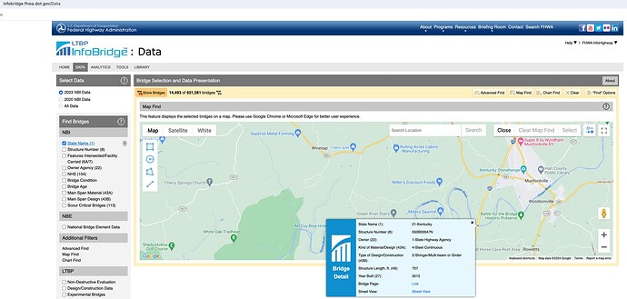
If you’re feeling really ambitious, you could wade into the Federal Highway Administration’s National Bridge Inventory data set.
Given your focus on truck routing, are you also adding weight limits to these bridges? Let us know if you have any questions about how to translate per-axle or specialized weight limits to OSM tags.
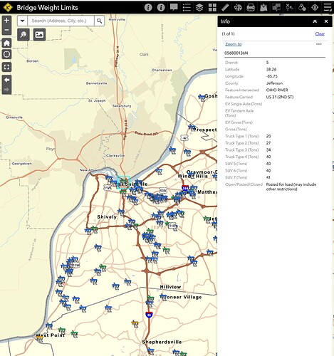
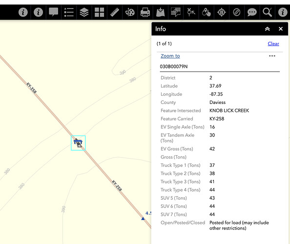
Thank you for pointing to this source. Will refer to this as well. For updating Kentucky bridge weight limit data for trucks, I am referring to Bridge Weight Limits from Kentucky Transportation Cabinet. As you will see it has physical locations of all the bridges and corresponding truck restrictions.
Here is a sample
Let me know if you have any concerns
Also, if you have some time can you confirm if I am translating information in tags accurately. For example for the bridge at the location (37.6930392,-87.345383) here are the details:
I am translating it into the following tags:
maxweight=37 st
maxweight:hgv:conditional=37 st @ (axles=2); 38 st @ (axles=3); 41 st @ (axles=4); 43 st @ (axles=5); 44 st @ (axles=6); 44 st @ (axles>=7)
maxweight:hgv_articulated=44 st
I referred to this sign on OpenStreetMap wiki to translate using this key maxweight reference page
Let me know. Thanks!
Thanks, do you happen to know if OSM has permission to reuse the data from this map? I found a similar KYTC dataset that’s available as a WMS but has a copyright notice that isn’t compatible with our license:
Copyright Kentucky Transportation Cabinet, 2019. All rights reserved. Proper citation is expected when used. It may be used in non-profit efforts.
It might be worth sending them a note asking for explicit permission to add it to OSM. We can provide attribution on a centralized page but can’t ensure that downstream users, including commercial users, will reproduce the attribution. Or at least we could ask if they’d be OK with us copying details off of their photologs, similar to how we can already trace off aerial imagery through the KyFromAbove program. If we can’t get permission from them, Bing and Mapillary have coverage of some of these highways from street level, but not as much as in surrounding states.
I believe this is correct regarding the “Truck Type” and “SUV” fields, based on this sign visible in the KYTC photolog. The “EV” stands for emergency vehicles, which would correspond to the maxweight:emergency=* and maxaxleload:emergency=* keys.
Unique to Kentucky are extended weight limits for coal trucks (any truck hauling coal or a coal byproduct). This page has some suggested tagging should you come across one of these restrictions.
This is likely where FHA is getting the data for NBI, but when the Federal government publishes it, it’s under a different license. ![]()
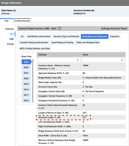
Thank you for NBI database. I was able to find the bridge length for each of the bridges. I will use that length to create the length of the bridge way instead of looking at imagery. For your reference, here is the data in NBI
Once you click on the bridge Page Link it takes you to the right page
On this page, we can see the bridge length
@PHerison @tekim Do you see an issue with getting this information from FHWA instead of looking at the satellite imagery
@Kai_Johnson looks like with this approach, we don’t have to worry about licensing. Let me know
I have a follow up question: what if I were to automate this and add bridges in Kentucky (wherever they don’t exist) in one-go, do you see any problems? I am really good with programming and automated checking to make sure that there will be no data issues. I plan to use QGIS, coding, JOSM and validators. If you want, I can go over the approach with you
- Make sure you know that the definition of “Structure Length” matches what OSM generally considers the length of the bridge.
- There is no method in JOSM that creates a way of a specified length, so you would have to manually shorten or lengthen the way as needed by dragging one of its end nodes until its length matches the FHWA data. In any event, even if you are going to get the data from FHWA you are going to have to look at imagery to see where the bridge starts, and its orientation.
To do this properly this would be difficult. One issue is that you have to snap to existing geometry in OSM. To properly add bridges in OSM you need to split the existing way at the start and end of the bridge, and then change the tagging (bridge=yes at a minimum) on the new way that represents bridges. You can’t just import the points from FHWA. In any event, this would be an import and must be documented and discussed with the community first, see Import/Guidelines - OpenStreetMap Wiki
As @tekim already pointed out, there is no lenght-tag in OSM, so you have to calculate coordinates of the end-node by using the other end-node as an “anchor-point”. Not worth in my opinion, as somebody else might change the node-positions and hence change the length later.
I would probably suggest focusing on the bridges that aren’t mapped as bridges yet in OSM (so excluding the example along KY 258). If there’s an existing bridge, an import could start out by adding missing tags, but if any bridge needs tags or geometry to be changed, it could instead flag the bridge for manual review. Another reason for caution around existing bridges is that almost 200 man_made=bridge areas have also been mapped. A bridge area is supposed to be connected to the roadway at either end, so you have to consider topology as you make any edits.
As far as I know, the NBI should be public domain like many of the other Federal government data sets.
One think to keep in mind is that per the notes on NBI data: “All data in the inventory and operating fields is downloaded in metric tons even if rating factor is indicated. The factor has been converted to metric tons.”
I received the following reply from Kentucky Transportation Cabinet. Is this enough or do we need to get something in writing?
Thank you for reaching out about using our spatial data to improve the accuracy and comprehensiveness of OpenStreetMap. The Kentucky Transportation Cabinet has no objections to your use of the publicly published data (properly cited) for the public good.
We have an automated process that publishes our spatial data (with metadata) to the Kentucky Geonet Portal on a weekly basis. Here you will find a variety of data that may be relevant to you including, data on bridges and roads. The KY Geonet Portal can be accessed by everyone from https://kygeoportal.ky.gov/geoportal/catalog/main/home.page.
1. You can search by keyword for available data sets
2. You can also Browse the catalog by content type or topic category
3. In the Results of your search, select Open to be directed to BOX where you may download the shapefile.
Please be advised that if you download the data it will need to be redownloaded weekly to stay up to date. Due to this maintenance, we recommend consuming services if you are able to do so.
I hope this advances your goal of improving the accuracy of mapping data and making roads safer, something we care about as well. If you have any other questions that I can answer please let me know.
I plan to email / call each state to get their permissions. Do you have any suggestions? Thanks!
This is helpful and thank you for reaching out to them. Their response is vague enough that I guess it depends what you asked them. Proper citation on our “Contributors” page on the wiki is doable, but we can’t guarantee the comprehensive attribution that, say, ArcGIS maps tend to display in the corner.
Every state probably has slightly different expectations. To save you some time, state DOTs in several states like Massachusetts, Ohio, and California have already released their GIS layers into the public domain. I don’t know if we have a list somewhere that keeps track of these things, but you can often figure out existing permissions by searching the wiki for previous import proposals from DOT sources.
@PHerison Did you look at National Hydrography Dataset (NHD) to import all waterways in one-go? We were looking to match the coordinates of bridges from NBI hitting OSM roads to tag missing bridges and found that this information provided us with accurate bridge locations. Let me know if you have any questions
@Minh_Nguyen @Kai_Johnson We created an import page to outline our approach to importing bridge information and then tagging bridges with truck routing tags. The current page only talks about the first page - import bridge information - but we will update it once start working on truck restriction tags. We are still refining and testing the import process including the code. We hope to have it ready for first import next week. Do you have any comments / suggestions?
HI @Maneesh-Mahlawat - I took a look at your import page on the wiki. Regarding:
This approach [JOSM Approach 2 - split way and remove old way.py] utilizes the Jython engine of the JOSM scripting plugin. It retrieves the active data layer and edit dataset from JOSM, then splits existing ways at bridge locations, adds bridge tags (
bridge=yes), and removes the old way. It accurately represents missing bridges by interpolating the start and end points of the bridge segments along the existing way segments.
After splitting a way you do not have to, and you should not, “delete the old way.” Splitting the way in most cases will result in three ways, one of which should be an edited version of the original way (probably the longest one). This preserves the history of that way in the OSM database.


