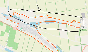
I believe the borders of the settlements of Pervomaiske (Первомайське) and Vodiane (Водяне) near Avdiivka in the Donetsk region are incorrect.
I have been following the war, and recently there has been fighting for the settlements, and what I’ve understood from messages from resources from both sides what is shown on the map as a northern street of Pervomaiske (shown on attached image), Naberezhna vulytsia (Набережна вулится) is actually part of the settlement of Vodiane.
Anyone have more info on this? What data the currently shown borders based on?
I think the borders of the two settlements should be adjusted and the street moved from Pervomaiske to Vodyane. The borders of the historic settlements councils should probably then be changed too.
Дійсно, кордон населеного пункту позначений трішки некоректно: від Way: 335987145 | OpenStreetMap на схід — це Водяне.
Тільки частина від кладовища на схід. Інша частина — це Первомайське.
Саме так, але тільки та частина вулиці, що у Водяному
fixed
