I don’t want to offend this Danish mapper (and I don’t know whether it is okay for him that I start this forum topic) as he puts a lot of effort into his contributions, but he has an unusual view on 3D tagging, especially with staircases.
Based on my observations and his statements in the changeset discussion, he uses these questionable tags for 3D mapping:
building=stair or building=stairs or building=steps (and building:part=yes with height=*) for staircases
He thinks “stairs” are indoors, “steps” are outdoors
Also, he shared a link to a map area where he added building:part=yes polygons for the staircase of a building=temple, blurring the distinction between building:part and area:highway …
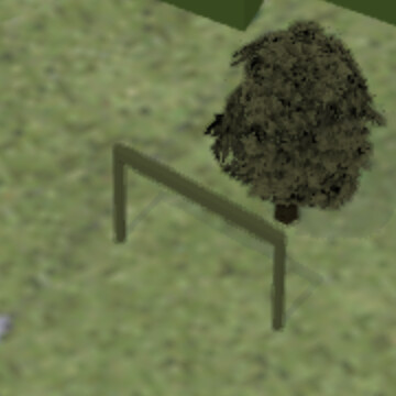
building=portal (and building:part=yes) for something similar to a garden arch, but simpler and rectangular in design
He plans to use landuse=garage or landuse=garages for driveway areas that lead to private garages
His primary motivation is that everything should look nice and detailed on F4map. I think that these tags are incorrect (i.e. tagging for the renderer), but I have also noticed the lack of alternatives (especially regarding the garden arch). I suggest having the 3D buildings tagging scheme extended to staircases (area:highway=steps) and man_made=* objects which aren’t buildings.
So, I’m looking for a fair balance between correct tagging, appreciation of hard work, and interesting 3D rendering. (Maybe consider the new and open-source Streets GL renderer for this?)
Mapping individual steps as separate areas? That’s a step too far in my opinion. A smart 3D rendered should be able to interpolate based on incline and step_count and width.
Also some tagging errors: nature=scrub is uncommon in residential areas, the mapper likely meant “bushes” or a wide hedge. Also used leisure=garden for what was likely meant to be landuse=flowerbed.
I appreciate the mapper’s enthusiasm, but I’d rather see that energy invested into improving other aspects of OSM, there are many regions where the basics (POIs, house numbers, and even major roads) are missing.
I would really not go there, this is basically equivalent of someone complaining that you are contributing to incorrect software project or should work full time for specific charity etc.
have you notified them about this thread?
mapping each step as a separate building is definitely wrong
even building:part would be extremely dubious
mapping individual steps is really extreme - if such super-detailed display is desirable then extrapolating in 3D renderer from less insanely detailed info would be way to go
if they really really want to map they should ATYL a new tag (though it will be NOT appearing in 3D renderers, unless it gets dedicated support there)
have you tried talking to them that building=stair is not correct at all?
driveway areas are area:highway=service if they really want to map them as distinct objects
do you have photo or even google street view of such object?
yes, if you talk about mapper (except cases of blatant and clear vandalism) I think it is in a good tone to let them know
(I definitely would want to have opportunity to explain my viewpoint or remind about missing facts if people would complain about my mapping on a public forum, and I expect the same to hold in general)
I do not see an issue with building:part=yes/building:part=step/building:part=steps/building:part=stair/whatever for individual steps - but they definitely shouldn’t be building=*.
It’s a very, very high level of detail, but shouldn’t matter to most consumers; there’s supposed to always be a single building=* around the building:part=*s as a fallback.
Yes, I’m mapping for the 3D renderer, but I never maps elements that doesn’t exist, just to make the Carto map look better.
The definition of “building” has for years evolved to be much more then just some kind of house. As I see it, a building is a man made construction which in some way is fixed to the ground or connected to the ground via other buildings (i.e. a construction like a roof or a portal).
In the past I’ve mapped steps as stairs but now I’m somewhat wiser . Steps should be used outside and stairs inside of building (the later usually not mapped by me). I can’t easily correct all previous stairs til steps, but I will do it as I retrieve them.
But in order to map a complete building in realistic 3D, real existing steps are necessary (we have very good fotos of this in Denmark). That’s why I consider steps as part of another building or as separate buildings.
Every single step in a “steps” is mapped by me as building:part=step. The outline of all these steps in mapped by me as building=steps.
Steps in streets, in landscapes and likewise will always be mapped by me as highway=steps.
I never map driveways as linear connections to a single dwelling house unless the house is situated away from a public accessible road. This is only in order to make car navigation work properly. This way of doing it is more or less the common Danish standard in order not to clutter the Carto map or similar maps.with irrelevant elements.
Garage as an area in front of a garage was suggested to me by another mapper. I agree on that t’s not a especially good tag. But if I use driveway (which definitely is better) I can’t render the area with a proper surface that’s rendered in 3D.
I will consider another approach to this rendering problem. Maybe trying out landuse=parking + surface=***
That doesn’t matter. Tag whats correct, not what looks nice. Because this is the definition for “Tagging for the renderer” - misusing tags so it looks good on some random renderer.
If you would like something to show up on the renderer of your choice, you should take that to said renderer, not bend the tags and values
And not, landuse=parking is wrong. Just use driveway with the proper surface tagging.
EDIT: Also, i like to add, using building:part=steps to map this is not correct according to Tag:building:part=steps - OpenStreetMap Wiki
Its use is to indicate the shape of a building. Steps are not a building.
Stairs/steps can be tagged with the length, width, step_count and what not. Tag:highway=steps - OpenStreetMap Wiki If the router does not show it, be it. The router should implement this. Other tags should not be used to bend the renderer to their will.
What do you do when other renderers show something else? Try to bend the tags further so everything shows up on every renderer?
EDIT2: Acutally, i’m still not sure what to think about the building:part=steps. Maybe it should be adapted so it could be used? Not sure to be honest.
[out:xml][timeout:300];
way[~"building"~"step|stair"](user_touched:"MicDK");
(._;>;); out meta;
And yes, regardless of whether the steps/stairs are 3D mapped separately, there should be a highway=steps way from the start of the bottom to the end of the top.
Tagging for the renderer, even to get a nice 3D-view with F4Maps is not ok.
Using undescripted tags is accepted mostly. Renderer may us them later. This could also be for 3D. But I would ask the maintainer of “all” 3D renderer for a new tag like “Steps" and discus the details, alike for the highway-steps. I am not sure, if F4map would answer at all. OSMBuildings for sure, Street-GL too.
There have been some requests now and then, but noting was realised. Meanwhile a kind of artwork is done by the now rendered Simple 3D tagging. Even as it’s odd, it’s mostly harmless. 2D rendering ignores it, vector-tiles to. Only the OSM data and the files get blown up a bit. I think, the appended example is still nice. But for more detailed shapes, we should have a better solution. F4map uses GLB files already. And WikiMedia is just preparing to host GLB files. If done, we may use a reference tag for komplex buildings.
I’ll take notice of many things. F.x. the difference between steps and stairs, never to map steps in open streets and lands as buildings, and not to use garages for parking areas in front a private house.
One last comment about mapping for the renderer. Yes, I’m mapping for 3D rendering, but I always map existing elements. That’s a decisive difference between me and those who map things which only exist in their fantasy.
The rules laid out say that we should not use specific tags to make objects show up in a specific way. We are supposed to use agreed upon tags if they are already agreed upon. And we are supposed to do that without thinking about how our work will show up in a sepcific renderer. That’s all.
There seems to be a misunderstanding - tagging for the renderer does not mean mapping fictional stuff. It means misusing tags so it shows up on some renderer you like.
Like garage for the parking area/driveway so it shows up on some 3D-renderer.
Yes, some terrible examples is shown on OpenStreetMap Wike - Tagging for the renderer. These are definitely crazy, totally wrong and should be avoided!
From the Wiki I also could have copied this :
“A misunderstanding comes when people say that you shouldn’t tag something “for the renderer” even though the tags being used are accurate and not misleading.”
But nobody’s perfect, and along the way I’ll try to fix my previous wrongdoings.