Confusion by whom?
Data consumers. I see a public bridleway mapped (correctly) as a bridleway in OSM but then find I can’t use the way as intended because it’s not physically accessible for me and my horse.
@Duja and @Casey_boy, I think you’re actually both on the same page: renderers and routers shouldn’t mislead anyone to think that they can realistically access the bridleway. It sounds like you only disagree on what the current guidance is.
Practically, the “access=* is only about legal restrictions” guideline is already a bit of a legal fiction in some cases, based on how mappers and data consumers are treating the tag. Neither a forum discussion nor a wiki edit will really change that. I don’t see the problem with documenting foot=* as a vague combination of physical and legal restriction and leaving it to foot:physical=* and foot:legal=* to clarify when necessary.
Depending on where you live, it’s actually really not. Here for example is an overpass query for “restricted byways” that only appear on the ground as something best described on a footpath. Legally, you can access that with a horse and carriage, but physically it’s unlikely to fit. Likewise, path and even steps.
What the legal right of way is and who’s allowed to use it is really important information to know, and that’s something that remains even if someone was later to widen the road (or flatten the steps) to allow (in this case) horse and carriage access.
Where does designation=restricted_byway fit into this? Is that an attempt to maintain information about legal access rights more stably than inside access keys? Does the existence of this key reduce the need for the access keys to be strictly about legal restrictions?
horse=unlikely + carriage=unlikely? ![]()
Or… I do not see why we need new keys, a new value would suffice.
Following on the fine UK example of having a road classification of unclassified, couldn’t they have come up with a better name than BOAT? ![]()
After all, with regards to transport & travel, boat does have another meaning … ![]()
The OSM UK community map public rights of way and use the as-currently-defined access tags to document the explicit legal access rights conferred to those ways due to their status.
how do you verify it on the ground?
Or maybe, in the case of barriers, just the barrier type is sufficient to derive likely physical accessibility - and no access-tags are needed.
Signposts.
There’s actually also a sign for that:
(Edit to use Wikimedia Commons link rather than the Wikipedia link so that the in-line image template works)
Signs and waymark arrow colour.
I did post a bit here, and learned that way, that there is access (legal) and accessibility (phyisical), in ordinary parlance. I’d say, these terms should work well in an international community. But when it goes to modes of transport, it gets tricky:
footability, horseability, you name it? Not so sure about that.
“Accessibility” refers to the physical attribute. As you point out, there is a potential for confusion because “accessibility” can mean different things depending on whose access you’re concerned about. In a software context, accessibility usually refers to the needs of the disability community. Some alternative terms include “traversible” (somewhat technical), “passable” (somewhat made-up), and “usable” (more nuanced than the other terms).
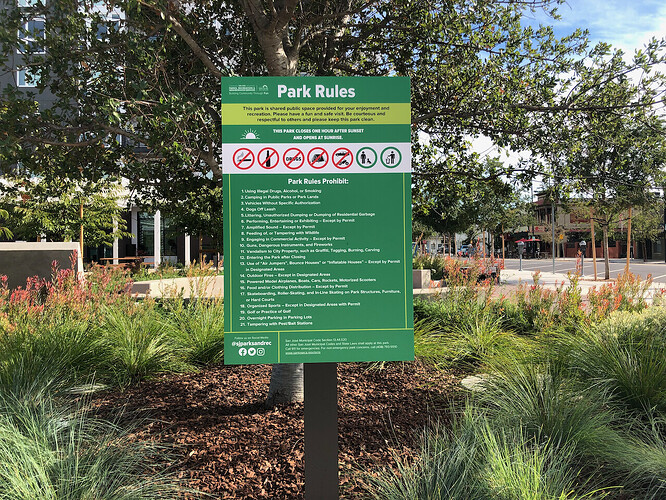
I’ve also been trying to avoid the term “legal” to some extent, because very many signposted restrictions technically have nothing to do with the law per se. In the U.S., a typical park or private facility will post various rules that guests are expected to abide by. These rules may or may not be based on any law, but there are still consequences to disobeying them.
These park rules are all legal restrictions, including rocket=no and musical_instrument:conditional=no @ dangerous. If you violate them, you risk getting fined, by authority of the ordinance cited in fine print:
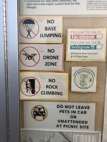
But I don’t know if the “No Base Jumping” rule at this park is specifically codified in a law:
So I’ve just been calling it “permission”.
I would use something like accessibility:foot or accessibility:horse. Annoying to type, but easy to understand.
this is a nice list of lots of (in part overly specific) restrictions, really a pity that it cannot be represented in OpenStreetMap because „tagging“ is included as a restriction. Are there places in the US where „illegal drugs“ can be consumed?
Only authorities know why are RC airplanes are forbidden but RC helicopters aren’t, and unpowered model airplanes either
I concur. I understood access restrictions including those that are bound only to property law, as file under legal. Mind you, there are also easements, those are not in the range of *=permissive.
As I’m sure you’re already aware***, we already have sac_scale and horse_scale. That’s not the complete answer to the concept**, but it’s part of it.
** I can think of “public bridleways” in England that are fairly flat, but overhanging trees restrict horse access.
*** because you’ve posted at https://community.openstreetmap.org/t/rfc-hiking-exposure-key-along-with-hiking-technique-this-disambiguates-sac-scale/99885 .
An interesting idea indeed, the term accessibility connotes that, there are grades of it. Still I do not consider sac_scale adequate to describe the difficulties in crossing barriers. Certainly, hiking is only compatible with locked=no on a gate, some stiles or closed lift-gates may beg for mountain_hiking when going over them. But for the higher difficulties, sac_scale knows nothing about e.g. spikes, barbed wire or other means to make barriers hard to get by ![]()

