Few minutes ago I did just that, or rather, I did add amenity=drinking_water to such a tap. That was in response to a note that was put there because the tap was invisible on some map. The tap was added with OsmAnd, BTW.
While indeed, the water comes out of a tap, it is in a public place and open to all comers. I think of that like adding highway=bus_stop to a man_made=post, bus=yes.
We can distinguish in theory between taps that are mainly built as sources of drinking water and taps that are mainly meant for something else, where the water just happens to be drinkable. I guess the question is whether mappers have generally made this distinction in practice, or have people just typed “water” into iD and selected the first preset that looked about right? Do we want to make this distinction as a community? How common are publicly accessible taps where the water happens to be drinkable but that aren’t mainly for providing drinking water?
I have seen it the other way round, a line of water taps in a cemetery where only one or two were signed as drinkable (apart the sign looking like the others) and for the rest there was a non-potable sign.
Hmm… I do see the point that it could be bit odd to have a lot of amenity=drinking_water in cemeteries just because the taps (for watering the plants on graves) happen to be connected to the public water supply instead of being fed by rainwater. These aren’t really POIs for the passing hiker or cyclist…
But surely we can improve the current situation. A semantic distinction between man_made=water_tap amenity=drinking_water and man_made=water_tap drinking_water=yes is not documented. Whether or not the drinking fountain you add appears on the map depends on which preset you happen to select in iD, and to the casual mapper it’s not going to be obvious that “water tap - drinkable: yes” and “drinking water” lead to different results. What needs changing?
Question to those who argue they are two different things, are you suggesting we document that for man_made=water_tap, you should
tag amenity=drinking_water if the tap exists mainly to supply drinking water
tag drinking_water=yes if the tap incidentally supplies drinking water
tag drinking_water=no if the water isn’t drinkable?
Hmm… I do see the point that it could be bit odd to have a lot of amenity=drinking_water in cemeteries just because the taps (for watering the plants on graves) happen to be connected to the public water supply instead of being fed by rainwater. These aren’t really POIs for the passing hiker or cyclist…
of course they are POIs for the passing hiker or cyclist, they are not interested in the reason why there is drinking water, as long as they can drink there or fill their bottles, these are just as good as a drinking fountain put on purpose for drinking.
Please note that whether a water tap provides drinking water does not only depend on the water source but also on the fixture and pipes, it is not so rare that fine water is contaminated on the last meter.
If different tags which mean the same thing are rendered differently (or not rendered), this is a problem for the rendering software.
True… One should ask data consumers to implement it (as I’ve tried requesting for OsmAnd drinking_water support, alas without much luck so far).
There is also problem if the drinking water is not just a node (like in man_made=water_tap case), but a polygon with different primary use; e.g. amenity=toilets + drinking_water=yes. How would that be displayed?
The issue is that obviously rendering should differ depending whether the user is wanting to see “toilets” or “drinking water” sources; which might indeed render differently in on-demand renderers like OsmAnd, but is problematic for general-renderers like Carto on osm.org website, which always display the same map, regardless of user preferences.
yes, that is how I would interpret it too.
Unfortunately, even if such amenity=drinking_water vs. drinking_water=yes distinction is rigorously implemented on the map (which is big “if”), it would only slightly help the user who is looking for drinking water sources; as too many sources still won’t be displayed (e.g. man_made=water_well, natural=spring, all those toilets/malls/etc. polygons…)
Yes, that’s how I see it.
If a POI or an area provides drinking water, a toilet, a campsite, etc., OsmAnd will show a water drop at this POI. Carto could do something like that too.
What I am primarily interested in is does it show different icon depending of drinking_water=yes vs. drinking_water=no on that amenity=toilets (ornatural=springorman_made=water_wellorman_made=water_tapor …)
If it is has same purple circle icon (does this purple circle symbolizes the toilets or what? I’m unfamiliar of the icon you’re talking about) for both situations, then that is problematic if one’s intention is finding a sources of drinking water (e.g. according to taginfo, about half are yes and half no, with just a slightly more drinking_water=yes).
OsmAnd map rendering above looks like a nice rendering solution (provided one can persuade Carto and other maintainers to add it), but my main problem with OsmAnd is with finding such sources or drinking water, not with their display (I mean, zooming map to the max so those get displayed, and visually scanning while panning whole map for dozens of minutes is obviously not the ideal solution; but just searching for Drinking water sources will produce only amenity=drinking_water, and unfortunately ignores all other sources having drinking_water=yes)
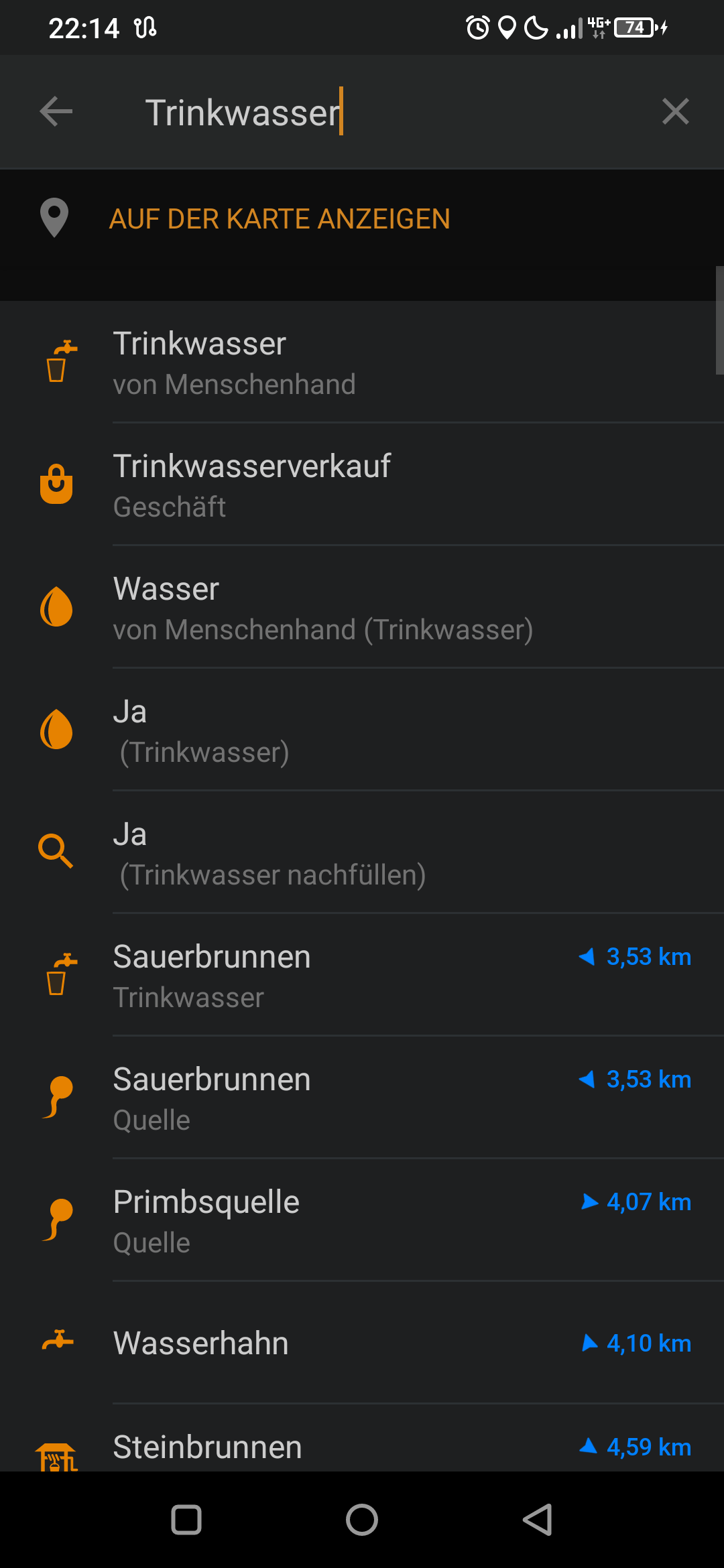
but it works in OsmAnd. Type drinking water into the search and it will return the following results. amenity drinking water; shop drinking water; yes drinking water; yes refilling drinking water. Sorry screenshot is in German.
There are two approaches for tagging that the water from such a public tap is potable (safe for human consumption): one approach is to combine the tag man_made=water_tap with amenity=drinking_water, the other is to add drinking_water=yes. Some mappers consider both variants to be interchangeable in the case of taps, others make a distinction where the tag amenity=drinking_water is to be used when the tap’s main function is to provide drinking water (e.g. for hikers or cyclists) and the tag drinking_water=yes is preferred when the tap happens to provide drinking water but that is not its main function (e.g. for watering plants)[1]. For non-potable water, the tag drinking_water=no is used.
Organic Maps also lets you search for “drinking water”, it shows both amenity=drinking_water and other things that have been tagged drinking_water=yes.
Agreed, although I’d want there to be a clear on-the-ground indication that the water is potable. I personally wouldn’t fill up my water bottle from a random garden tap just because OSM says it’s drinkable (unless I was in dire need of water!).
I have a strong preference for water sources that are clearly intended for drinking. It’d be great if the tagging scheme (+ apps that display the data) made this distinction clear.