Also, if a CDN or some other sort of caching were to come into play, of course longer-held tiles would make everything faster.
I’ve released a new version which breaks the storage down by-layer. This means that it’s possible to only regenerate the layers that have changed. For example, if you add a new building it won’t have to regenerate the roads layer.
This has brought the update speed up to minutely, taking seconds to consume a minute’s update.
I’ll set up automatic jobs to handle the coastlines and low zooms, then get back to issues reported in the tiles. With updates so much faster, it’s easier to develop. Thanks for @SomeoneElse doing a lot of good testing.
25 Likes
I posted a diary post covering how I made a change to the generation.
4 Likes
I have a demo page now running on OSMF hardware.
A database reload has been completed with all the updates.
23 Likes
This is fantastic, huge congratulations!
Out of curiosity tried to use the shortbread tiles in an interactive viewer. Got it plugged in and ready to roll in a few minutes
Landuse layer explorer: amche.in - Free Maps of Goa

3 Likes
Aargh, this morning it was too early, and I look again now and it’s too late to see the daylight map !
2 Likes
Which daylight map? ![]()
1 Like
I added the four versatiles styles to https://vector.openstreetmap.org/demo/shortbread
7 Likes
The zoom level on the Versatiles styles seems to be limited to 18. Is that deliberate, or just an accident?
No wonder, as daylight was overturned when the night set in… ![]()
Luckily, we can still save the Planet, as long as we don’t trace the 400M steps of the orange cookie monster.
It’s just the default. It also happens to be the same scale (but different zoom) that the Standard layer is rendered at.
Yes, but surely the point of vector tiles is that higher zooms don"t need server recources or pixillated browser overzoom - they can make hidden features (present in the z14 tiles) visible.
1 Like
In theory, you can display z14 tiles at arbitrary zoom levels. In practice you run into issues with the coordinate precision used in the tiles. Compare Way: Kirche St. Peter und Paul (39374343) | OpenStreetMap on the standard Carto map with how it is displayed in the “Cycle Map” at zoom 18.
1 Like
True - the way that Tilemaker handles it is to optionally allow extra precision in z14 tiles (as an alternative to lots of z15 tiles). Compare this small maze on osm.org, using OSMF shortbread tiles at vector zoom 21, and using Tilemaker-generated tiles at vector zoom 21 (and the equivalent raster).
Separately to that, it’s still useful to be able to zoom in to see things that are otherwise hidden (even if some other things look wonky).
Edit: Fixing URLs - I pasted the wrong one in by accident initially.
1 Like
Like I said, z18 isn’t an intentional choice. I don’t think it makes sense to increase it any more than z19, which is twice the scale of the standard layer.
z19 of OpenStreetMap Carto or z18 is 29 cm/px (or lower scale away from the equator. Zooming in more to avoid overlapping symbols isn’t really solving the problem. In dense areas with multiple levels it’s easy to have POIs too close, even as you get to absurdly low scales. In print cartography techniques like displacing labels or multiple maps for different layers would be used. For something online, interactivity is probably the answer.
I am going to increase the zoom on the demo page because it’s a demo page. The ability to zoom in excessively is useful for testing.
Right-To-Left text is not handled correctly: https://vector.openstreetmap.org/demo/shortbread/#3.94/29.76/32.57
Israel is rendered as “לארשי” instead of “ישראל”
Egypt is rendered as “رصم” instead of “مصر” and ligatures don’t seem to be handled at all. Ligatures are required for Arabic. However, I don’t actually speak Arabic so best if someone who does confirms.
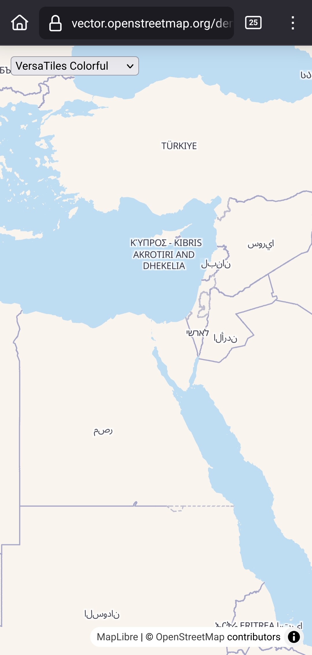
Firefox on Android.
1 Like
An extra zoom level (Z20 raster, Z19 vector) is very useful for traditional markets, where the market stalls are too close packed for Z19. There are no real alternatives to zooming in that bit further. G**gle-type maps are usually terrible for these places, so it’s an area where OSM maps can shine.
2 Likes
The story from here is that “MapLibre GL needs an RTL plugin” (haven’t tried it myself).
2 Likes
Thanks - some things that seemed to be missing before are definitely there now. Including things like the subtags on tourism=information and amenity=fast_food. I have a bunch of icons for these sat around elsewhere, so I’ve updated the style I have pointing at these tiles.
Interesting. I wonder if this should be made part of core MapLibre instead of a plugin? Bidirectional text rendering is a requirement for Unicode compatibility, and there is no circumstances where you wouldn’t want it.
1 Like