The style may not be controlled by OSM or the OSMF, but Carto Is run on OSMF hardware and is propagated largely because it is on said hardware.
The vector tiles would be much the same and its pretty normal for it to be given a similar degree of scrutiny.
Actually you can use any shortbread compatible mapbox-gl style you want.
While we are kind of assuming that the OSMF might provide a selection of such styles together with the vector tile service, it isn’t a given (and they are not doing it at this point in time).
Just a remark. Please, try to avoid promoting the direct tiles URL, but in place promote the tilejson URL. We have now a new chance to avoid the attribution drama. As the tilejson include the attribution, and show it by default on map (like in MapLibre GL).
Not everything that support vector tiles supports tilejson.
for example:
![]()
Making people parse JSON in their heads isn’t the most user friendly strategy.
Lake “Obersee” Relation: Obersee (32367) | OpenStreetMap broken in the Demo map https://pnorman.github.io/tilekiln-shortbread-demo/#12.43/47.20893/8.8746 ?
Next:
- Upload your personal map style to openstreetmap.org
- Share maps in that style
Would be wonderful
says
Your ability to open an issue in this repository is currently blocked. If you feel this is in error, please contact the repository’s owner.
I was going to suggest that
https://pnorman.github.io/tilekiln-shortbread-demo/
add a “zoom to my current location” button, so people can see nearby tiles without having to pan and zoom and pan and zoom manually,
That’s just an example github repository - can you create a map somewhere else on a bit of web hosting and implement it?
I see. An example repository with example issues.
Rather advanced. So I’ll be leaving this topic. Thanks anyway.
Not really - it’s literally just creating a web page with the same contents as the current one but with an extra button on it. You don’t even need to change the map style.
Lots of people have been keen to offer “dark mode” help and advice elsewhere - maybe someone will help you here?
@pnorman Is it planned to keep the “OSM Carto” style for vector tiles, especially on Lines, Areas and Symbols, or to change the style?
Just to take a step back (since someone was asking a related question elsewhere) there are are two parts to the answer.
With vector tiles, the first part is “is a certain feature included in the schema”. In the case of Shortbread, the current schema is here. The current example tiles use Shortbread, but I’ve no idea about future plans (that may be a question for the EWG).
The second part of the question is “will any particular map style show a particular feature”, and if it does, “will it show it in the same way as OSM Carto”.
The example map based on these Vector tiles is using the “Versatiles Colorful” style. That doesn’t show everything, and it shows things in a way more like OSM Bright than OSM Carto. However, creating a different map style based on a vector schema is essentially an artistic exercise rather than an IT project.
Based on the number of people with an opinion** about Dark Mode, I’d expect thousands of OSM styles to appear real soon now.
** yes, I know what opinions are like ![]()
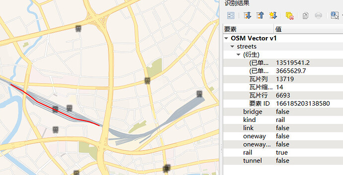
Does the “service” attribute of “streets” layer work on railway lines? Can’t remove yard lines when zoomed out ![]()
To clarify the above question a bit - the schema says that the “service” field should be set to “value of service=*”, but service appears not to be set in the picture above.
At least one implementation of this schema does do things with “service” on railway == "rail", so I’d suggest creating an issue at the issue tracker that was linked above - it looks like a feature of this implementation, rather than the schema itself.
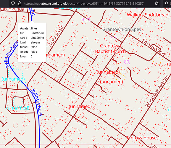
I created this for my own use, but am sharing it here because it might be useful to other people too. It uses different colours to highlight different map layers. It’s not supposed to look nice; just to show you what is there.
I believe that everything described in the schema is included. If a feature does not appear it might be because:
- it’s not in the Shortbread schema.
- it’s in the schema, but is for some reason missing from the OSMF vector tiles.
- it’s in the tiles, but there’s a bug in this style.
There are lots of features in the first category, and there seem to be a couple in the second. If anyone finds anything in the third category please let me know!
(crossposted from diary)
I repeated the test I did in March this year:
I slowly zoomed in the map from minimum to maximum zoom to the central station in Hamburg in a window of approx. 1600x800 pixels on a desktop PC and checked how many bytes where transferred. The result is
| Map | Description | Transferred |
|---|---|---|
| OSM Carto | osm-carto raster tiles | 14 MB |
| OSM Vector | shortbread vector tiles generated with tilekiln | 66 MB |
| Versatiles | shortbread vector tiles generated with tilemaker | 13,5 MB |
| JawgMaps | proprietary vector tiles | 4,5 MB |
(click the links to view the maps yourself)
I am doing these tests because I consider making StreetComplete solely rely on OpenStreetMap infrastructure, i.e. using the vector.osm.org tileserver for the app.
But at the moment, this continues to be ineligible, as it would increase the map download size about 15x-fold over the current map tile provider (JawgMaps).
Is (more) geometry-simplification planned at all for the tiles hosted on vector.osm.org?
I’m guessing that StreetComplete would also require some missing features too - like at least some barriers, which don’t appear to be in the Shortbread spec?
No, that isn’t required, it would just be nice.
Why is tilekiln producing 5x larger tiles for the same schema?
What about ref in roads, in public transport lines…

