Anybody using sac_scale=mountain_hiking in flat land? What did prompt you? Can share pictures?
1 Like
Using Overpass I found an unusual example in the Netherlands: a steep coastal sand dune: Way: 356043505 | OpenStreetMap
I can confirm that walking over that sand dune is demanding enough to validate this tag.
Most other sac_scale=mountain_hiking in NL seem to be steep paths through hilly forests: overpass turbo. Obviously this tag is super rare here.
Unfortunately I don’t have any pictures and the few instances of this tag within cycling distance of where I live are probably invalid, but if you’re lucky you can find something on Mapillary.
Looks to me like anything that can be classified as a hiking trail can have a sac scale (probably always T1 in flat circumstances). But it combines difficulty with how well the trail is marked.
The first 6 scales relate to walking, while the mountaineering scale ALSO relates to walking :))) You have to move through 13 different scales before you even arrivate at the UIAA climbing scale.
Tbh OSM should drop SAC scale and make its own difficulty scales:
mtb:scale 1-6
hiking:scale 1-6
climbing:scale 1-6
Trail visibility marking quality separate.
Sorry, I feel I’m already off topic ![]() Couldnt helpt myself
Couldnt helpt myself ![]() Sorry @Hungerburg
Sorry @Hungerburg
I think your wishes are already fulfilled: the definition of hiking difficulty is based on the SAC scale, but trail visibility has been taken out. See intro of Key:sac_scale - OpenStreetMap Wiki
1 Like
Well, this assumption I am about to test! Even paths in the mountains not always are steep, yet commonly mapped mountain_hiking. Steepness of the path is not a specific ingredient in the scale, a 30% incline road with asphalt paving certainly is not turning into mountain_hiking when walked.
Would you be able to share a guess or an educated guess at how many paths that are tagged sac_scale=hiking in your area would qualify as mountain_hiking under the deliberations (that I am fine with) you mentioned? (Inviting @Peter_Elderson from the Netherlands)
I guess this is not about steepness alone, maybe mountain hiking also implies risks like rockfall on the way?
That would be hazard=falling_rocks, so I hope not
1 Like
hazard=falling_rocks is a specific tag for specific situations with higher probability of rock fall (likely with such a sign), while the general danger of rock fall on mountain hiking paths is implicit. Btw., it isn’t very probable you get to end under the falling rocks, although it happens, but more likely you might find your way obstructed and will have to back up.
Perhaps a bit of context, to keep the talk on what I meant as topic.
Some tout sac_scale as the Swiss army knife of tagging footways posing some difficulties or risks that some people might have problems with.
Now, sac_scale=hiking is a way to tell readers, that there are NO such problems to be expected.
Therefore, any way that poses problems would have to get tagged mountain_hiking, as the next upgrade. In flat areas that might ring counter-intuitive?
Unfortunately this is inaccurate. Numerous T4-T6 graded routes (not walking routes, but scrambling) were previously graded L/F and WS/AD in SAC club guides. One example: Fluela Wisshorn NW ridge, now graded T5, previously WS. Note that some regard the crux on this route as UIAA II, although I think this may be overgraded as it looks harder than it is in practice and feels very exposed.
T4-T6 also include routes which would not have had a mountaineering grade, but which were covered b the top grade of the previous three point scale. These involved very steep slopes with grass, loose rock etc., and were common in the Voralpen.
Nah, the upper grades of the Mountain Hiking Scale include increasingly passage over non-walkable terrain.
Reading Rock Climbing - UIAA I get the impression, that the association considers that system a legacy that they dearly liked to get rid of. The reason why may not resonate well with OSM circles:
we find that in every area, where alpine and/or climbing activities are deployed, there are different difficulty scales […] with always local and difficult to export benchmarks
Seems a slow burner this topic. I fully understand, sac_scale is a niche tag of use only in a small domain, i.e. users familiar with it - mostly OSM geeks. Yet it managed to get quite some power on routing engines decisions.
The SAC recently changed the document with the rules. It is not compatible with the old rules that the OSM key got based on. I did add to the Wiki talk page. No response for two weeks.
Meahwhile, watching this https://www.youtube.com/watch?v=dYqQp_01hBo - starts off quite British ![]() Not much of Austrian style mountaineering to be seen in the beginning.
Not much of Austrian style mountaineering to be seen in the beginning.
I have argued elsewhere that sac_scale is really about technique and exposure. (It’s not about other difficulties, such as boggy paths.) If you need to be sure footed and a fall could be dangerous, I don’t see an issue with tagging mountain_hiking or higher even if the path isn’t, technically, in the mountains. It could be on steep cliffs near the coast or a lake. Doesn’t matter if it goes from 0 to 200m or from 3400 to 3600m.
Having said that, it’s very hard to imagine a path in entirely flat land that deserves an sac_scale rating other than hiking.
1 Like
How about this one? I do not see a well cleared/developed/gebahnt way there. The terrain is not entirely flat, yet it is not in the mountains. Still I’d say, sac_scale=hiking would be wrong:
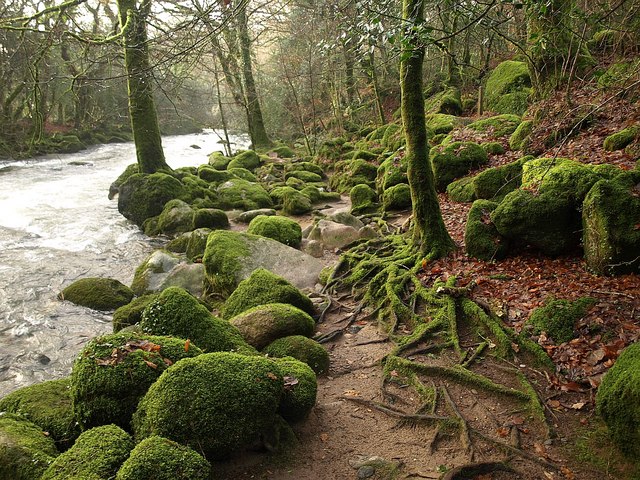
Source link - File:River Plym - geograph.org.uk - 1620054.jpg - Wikimedia Commons
I’d be curious to learn, if such gets tagged hiking nevertheless?
A bit trickier: continuous trail, so much for certain, but well cleared?
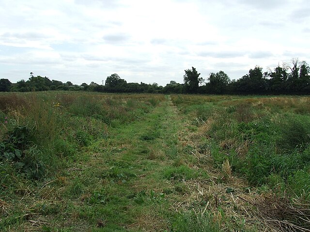
Source link - File:Footpath - geograph.org.uk - 3132476.jpg - Wikimedia Commons
1 Like
I write, because recently in the German part it got suggested to tag something similar as River Plym with sac_scale=hiking, because - who knows - you are certainly not running any errands there, you likely go there in spare time for hiking - and that got me complaining, sac_scale is not about intent, it is about difficulties, and hiking meaning the absence of.
Is sac_scale any-of or all-of? In flat land all-of always will fail so hiking will always win. If it was any-of, situation might be different?
Great examples.
The first one is tricky. You are right that it’s not exactly easy walking. Maybe a combination of tags like smoothness and would be better for expressing its difficulty? (And before someone says, smoothness is only about the movement of wheels, yes, I know, but once you get to the bottom half of the scale it starts to affect walking.) If I had to choose one of the six values I would probably choose mountain_hiking.
The second one is a clear hiking to me. As for whether it’s “well cleared”, well, that’s a translation of the German “gut gebahnt” and I am not even sure what that is supposed to mean. If it’s about the path being cleared of obstacles, then surely it’s the same if there weren’t any obstacles in the first place!
1 Like
I’d also tag the first one as mountain_hiking (those tree roots could twist your ankle, so “Hiking shoes recommended” and “Some sure footedness” needed) and the second one as hiking (looks quite smooth).
smoothness is about the usability for wheeled vehicles, but can also be applied to paths that are too narrow for vehicles: you can try to image “If this path was wide enough to drive on with a car, what kind of car would you need?” If you need a mountain bike to ride a path, its smoothness is probably very_bad or worse, and its sac_scale, mountain_hiking or worse
But the lower grades (UK equivalents Easy/Moderate/Difficult) are quite useful for non-climbers. Hardly anyone bothers with climbs at these levels: most beginners will start at Very Difficult or Severe, and some can easily climb at Very or Extremely Severe on their first day.
I remember a friend who climbed at VIII or IX, saying there’s nothing difficult on the Eiger Nordwand as the hardest pitches are V! Everything is relative!
For me, that is a non-starter, it is mountain hiking of course! sac_scale=hiking is definitley wrong there. So the next grade at least. But I am from a mountainous area and I’d like to solicit thoughts of people from non-mountainous areas.
I did consult the Oxford dictionary (via google):

and also DeepL:

Obviously, paving must have other meanings than the one it is used for in openstreetmap. paving the path - Deutsch-Übersetzung – Linguee Wörterbuch
As natively speaking German, when I read “gut gebahnt”, I understand this to say more than “no obstacles present”. Actually, willow branches hanging into the airspace would not be contrary. It says, that there is a path on the ground that clearly sets out from the surroundings, most likely constructed, perhaps even using imported material. If only trampled, then by a horde of elephants at least.
PS: The second picture to me looks a highway=track+tracktype=grade5 - I might map a path if there was a signposted hiking route there. Not from a country with PoW concerns though.
I find the second one difficult to classify. It’s most likely easy hiking, so hiking would fit. But there are several issues/questions:
Is it an official and regularly maintained hiking path?
Otherwise one could expect well-hidden, possibly ankle-twisting “potholes”.
Perhaps more importantly, 4 weeks later the path may be overgrown. This just doesn’t really look like a “well-paved path” (“gut gebahnt”) to me. However, if it is well maintained and easy to walk, I would tag it as hiking.