This discussion is getting a bit confusing because it’s both about trail_visibility and sac_scale. One thing they have in common is that their first level is based on the German phrase “gut gebahnt” which is translated to English as “well cleared”.
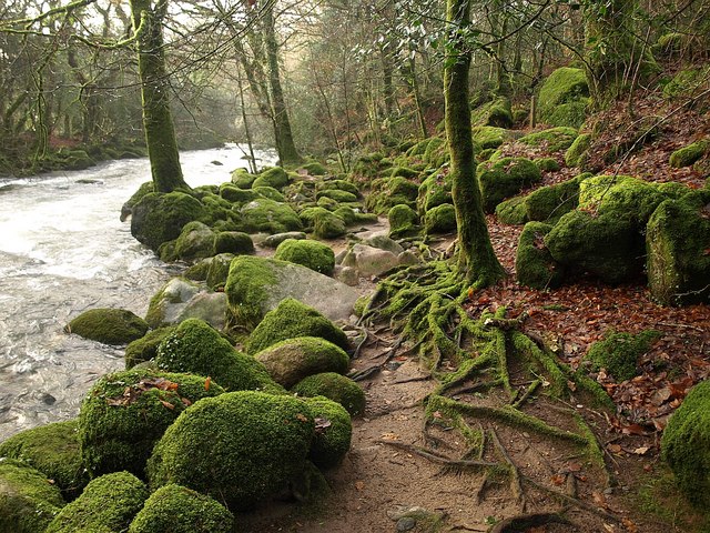
On our hike yesterday we came across this path. Can I assume we all agree that is a good example of “gut gebahnt”?

I would certainly tag it with trail_visibility=excellent because it’s dead obvious where the path is. I think this is because the path has been enhanced by human hand: it has been cut into the slope, maybe by a bulldozer. I think this is what distinguishes a trail_visibility=excellent path from a trail_visibility=good path. A trail_visibility=good path is also easy to see and follow, but it has not been shaped by human hand. It is like an informal path, i.e. it “has not been established on purpose” (from https://wiki.openstreetmap.org/wiki/Key:informal ). A trail_visibility=excellent path, however, has been enhanced by human hand, because it has been bulldozed, has been paved, gravel added, secured with a fence, etc.
Similarly, I would tag this path with sac_scale=hiking because there is nothing that makes it technically demanding. Reading the wiki, the most notable difference I find between sac_scale=hiking and sac_scale=mountain_hiking is the recommendation of hiking shoes and some sure footedness for the second. I think the thing that makes this necessary for sac_scale=mountain_hiking is the presence of “obstacles” (still looking for a better word, maybe “roughnesses”?). The “gut gebahnt” of sac_scale=hiking can then be interpreted as their absence, i.e. it is “clear” of them (by human hand or naturally doesn’t matter). Of course no hiking trail is completely clear of them (there are some pine cones and a tree root on the photo) so there will be many cases where a mapper will be in doubt if their number justifies tagging it as sac_scale=mountain_hiking or it is a case of the “bad end” of sac_scale=hiking. If there are only a few and they can easily be avoided, then it can still be tagged sac_scale=hiking. I also noticed that on this path, we were walking much faster than on the preceding sac_scale=mountain_hiking path, so maybe the average speed a hiker can make on a path could be an additional criterion to decide between sac_scale=hiking/mountain_hiking (on a sac_scale=mountain_hiking path, you need to slow down).