Thoughts about the future of OSM

Back on topic, there was an interesting comment on Hacker News today regarding Overture reaching “beta”-status

It’s not a risk per se, but it feels like a shame that there’s now two parallel efforts instead of one integrated effort of open map data. Overture can’t take away our hiking apps, but could mean future car navigation apps get built on Overture instead of OSM data

Post link

You are being too cynical. There’s a lot of data outside of open streetmap that complements open streetmap. A lot of that data is open but hard to combine with openstreet maps. And some of that data is owned by companies that are willing to license the data in an open way.

Overture basically is a joint effort by several companies to combine all that data.

Speaking as someone who has worked with OSM data. It’s great for maps but severely lacking elsewhere with a lot of incomplete data, poorly/inconsistently tagged data, lot’s of regional variation in tagging, etc. All this presents challenges for users of this data wanting to build stuff on top of this data. And there are lots of companies that are replicating efforts to fix this between each other. Been there done that. This is hard, non trivial work.

Overture is an attempt to move on from lots of companies reinventing this wheel to get to a state where there is a decent data foundation to build their applications on.

And they are releasing that data under an open license. So, there’s a lot to like here. The process of how this data is produced is not as open unfortunately and it is unfortunate that they are doing this outside of the openstreetmap community.

But then perhaps that community wasn’t that welcoming to get such a thing done? Nor have they seem capable or willing to do such work themselves. Overture are clearly working around them and it’s worth spending some time reflecting on whether that could have worked differently and what would have had to change on both sides for that to happen.

1 Like

Is there any effort from OSM side related to autonomous vehicles? Like, is it even possible? The future of maps seems to be converging to that.

What objects would you want to map? The vehicles?

1 Like

People are thinking about it. This is from 6 years ago.

Also:

https://blog.openstreetmap.org/2016/04/01/osm-driverless-cars/
:wink:

Two different purposes:

  1. A community of mappers making some “stone soup”
  2. A group of corporations that want to avoid paying licence fees to Google.
3 Likes

Good presentation at Boulder, if a bit dated (“10 cm of accuracy”), as six years is a while in high tech. It’s not (only) about not paying licensing fees to Google, although corporations (via their legal departments, initially, and by hardware, software, firmware engineers and cartographers after good guidance from them) have to pay attention to “how they use Google’s (map) data when making a map.” It’s actually a lot more complicated than that. As a professional cartographer for an AV company and specifically asking this client about how OSM might integrate into its maps OSM data (the answer from corporate was “as another tool, as a data source that can provide this company valuable mapping input”) with the company’s “cartography” (data, product, process…), it’s a LOT more complicated than that. It’s not (in my opinion), “a shame” that these are (necessarily) diverging. Conversations, dialog, potential integration strategies, questions about accuracy, update latency, safety…these continue.

Companies making AVs and especially making maps for AVs are teaching these robots a very specific set of aspects about “the road(s) around them.” They fit into a set of specifications that are amenable to being directly consumed by their vehicles — by design — as these data and processes “grew up together.” They are not the same (similar, but different) as what might be (or are) obtained by a crowdsourced public mapping project like OSM. I say that first-hand. And because I have signed NDAs, I shall not say more than that. These (mapping, cartographic) data diverge. For precise, technical reasons. Their creation is proprietary. They are simply not the same as OSM data and I think anybody can understand that, because they need to “feed” a particular set of inputs by an AI in an AV with realtime inputs and much sensorial and situational awareness (in a digital realm) with the AI itself being transported at speed. And most of the time, with human passengers, indeed as precious as it gets.

You might imagine how the concept of safety washes over huge amounts of, even the entirety of, these processes. Safety really must be a 100% constant concern of AVs.

Unless you are Google, “avoiding paying Google” (licensing fees) is really almost a small-to-vanishing concern regarding mapping / cartography for AVs. High-quality maps must be built with care, or they are not high-quality. “Using the map to cheat” (as Philipp said) is something both humans and AVs do, for similar reasons, in similar ways. Fixed objects CAN AND DO become different objects; think of a crosswalk being repainted.

I’m all for sharing (within the parameters of our ODbL), understanding that OSM might not “get back vision AI algorithms from AV companies,” and I’m OK with that. If AV companies are OK with sharing, I think there both is and can be symbiotic relationships in multiple directions. These seem to exist, even improve, especially as such dialog continues.

In my Doofenschmirz modus I consider AVs, and AIs feeding them, a huge opportunity to rule the world. I wonder where Perry is, though.

PS Basic General Education Knowledge:

I don’t know your Doofenschmirz modus, so I honestly wonder: do you mean “rule the world” in the dystopian sense of AVs being like, “robot armor” (tanks, mechanized artillery vehicles…war machines to kill humans, really)? If so, I’d like to read whatever you have written, as I find such matters fascinating. And, who is “Perry?” (Sorry if I’m supremely ignorant of your references).

Also, apologies if this gets off-topic; Peter, we can take this to private message if you like.

I would think that Tomtoms interest in OSM shows exactly the opposite.

Yes there was a short fad that saved Tomtom and Here from going belly up half a decade ago, based on the assumption that autonomous vehicles could/would only work if everything was mapped down to cm precision. That was obviously false at that point in time and hasn’t become any less false since then.

Naturally autonomous (non-tracked) vehicles do/will need reasonably good maps (as in being able to generate at least a draft route to the destination) to provide an acceptable experience.

BTW the poster child example at the time was always having exact positions of traffic signals (in 3 dimensions) because reliable detection of them, back then, was considered difficult.

The future of car maps.

I’m 100% happy with OSM being the best map for people, which right now it is and looks likely to continue to be. If your preoccupation is maps for autonomous cars, then map whatever autonomous cars need! As ever, “OSM side” is just the aggregate of whatever OSM contributors find interesting.

11 Likes

I can’t find it now, but I remember reading a joke proposal for OSM to enable traffic monitoring and whatnot by updating the location of every vehicle in real-time. (Without any updates to the system other than hundreds of changesets per minute.) Haha

1 Like

At least in the near term the answer appears to be no.

1 Like

Anyways the AI industry has already pivoted to in-car assistants that can plan you a route and teach you geography while you’re driving, maybe. I don’t see too much of this stuff being based on Google Maps or the HD maps of yore, but what do I know, I just map here.

1 Like

That much is true, OSM is at least a big free MMORPG that contribute to something useful :wink:

8 Likes

Hello and good morning!

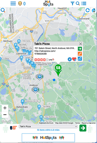
We have 5 mobile/desktop apps in production and host our own instance of Nominatum. Each displays a Google Map (free) and uses OSM data to place markers on the map for locations of interest. If OSM were to ever go away, it would definitely kill these apps (and many others). Google Maps data is WAYYYYYYYY too expensive!

Go OSM!!

2 Likes

Nice to hear you use OSM. However, I am curious what are the reasons for using Google as Map for the display?

Good question, Robert!

We use the free Google Map for display as we do not have sufficient server capacity to setup a tile server. We could use the public tile server but that would not be very friendly to the community.

If you are curious, you can checkout the apps and perhaps HotSpots as a decent example and switch to MapView in the upper right.

<tldr>
If Google started charging for the map, that would force our hands. We would have a business decision to make. If the apps generate sufficient revenue to cover the additional server capacity, then we would reserve a month to setup/configure another AWS instance, perhaps with enough horsepower for both Nominatum and an OSM tile server and reserve extra capacity for future growth.

If I were not so busy with other things, this might make a great Use Case Study for the many map-based apps out there… and those to come… that need map services. Perhaps such a thing already exists and I’m unaware. Getting to a Google-free app has tangible benefits, except of course deployment on Android.
</tldr>

1 Like

Then lots of markers will be placed in large unicolored spaces, I think.

Good point, Peter. If we switched to an OSM map, we would also have to replace the google-based libraries we use for markers. We use custom marker icons that we render ourselves in CSS, but they are positioned using the libraries. They show a combo marker once the marker density threshold is surpassed. Users can click on the combo marker to zoom in and show the enclosed markers.

If we would be talking about Germany there would be still free space to add new features and improve the whole thing, but if we talk about many other countries OSM is just barely usable

As for me, this is a post that proves one thing, how little you know about OSM. (There is also a second possibility of trolling the forum.) In the case of, many countries OSM is the only map available and up to date. For this reason, it is used by Doctors Without Borders and United Nations agencies. If you are interested in the topic, please take some time to look for information on our project.

3 Likes