The World's biggest benches, according to OSM

Glad to see you’re also adopting the size of Belgium as a unit of measurement! Although a tad unconventional, you’re not the only one using it; see The Size Of Belgium :smile:

7 Likes

Indeed; Wales is of course the standard here.

:slight_smile:

2 Likes

It is ! :ok_hand:

But since we never know if the data has been mapped on purpose one should always ask the mapper if the edit was intentionally.
Maybe it’s an idea to send a automatically generated “question” to the mapper?

“You sure this 55 km² tree is what you want?”

1 Like

Cleaned up that area of plenty of benches :smiley:

1 Like

I’ve cleaned up several of the largest buildings and the biggest car park.
Thanks for compiling this list, awesome!

4 Likes

…gone as well, as a landuse=construction instead of building=industrial.

1 Like

Just skimming through some of the top tags with over a million ways, some interesting ones might be:

  • landuse=farmland
  • amenity=parking_space
  • leisure=swimming_pool
  • leisure=park
  • leisure=garden

And if you can do linear distance instead of area:

  • highway=footway
  • highway=steps
  • (Really, probably most of the highway= values might be interesting)
  • service=driveway
  • barrier=fence
  • barrier=wall
  • bridge=*
  • tunnel=culvert
  • natural=tree_row

Just brainstorming because you asked; I personally probably wouldn’t be doing anything with the data.

4 Likes

Great idea, looking for unusual sizes unearths a ton of anomalous features. There are loads of tiny “houses” that in reality are sheds or garages (or massive industrial buildings at the other size extreme). I’ve also seen ping-pong tables tagged as sport=tennis, which then erroneously show up as “tennis courts.” Likewise, some super-sized “swimming pools” reveal themselves to be swimmable lakes or aquatic centers (with multiple individual pools).

Inspired by this thread, I implemented 4 new filters in GeoDesk for Python, which select features based on their minimum/maximum area or length. These are now part of Version 0.1.10 (pip install geodesk -U).

So, for the houses example above, you can use:

world("a[building=house]").max_area(35).map.show()

The maximum value is specified in (square) meters, but you can also specify an explicit unit (feet, miles, etc.), e.g. max_area(feet=300)

If you want to be able to navigate to the current object on OSM when you click on a marked feature, add a link attribute to map, like this:

.map(link="https://www.osm.org/{osm_type}/{id}").show()

Or, to open features directly in the iD editor:

.map(link="https://www.osm.org/edit?{osm_type}={id}").show()
6 Likes

I tidied up “building:levels”=“222222” earlier. :joy:

3 Likes

Thanks, that’s very cool. It was Geodesk that inspired me to make this list, because it’s so easy to iterate over features and calculate their area.

I did the above just for fun but if we find any systematic errors that are easy to correct from aerial imagery, then we could create Maproulette challenges similar to how TomTom does it for unusually small features.

Good idea, unfortunately I can’t create such a permanent link programmatically because I don’t have the object version number. They get thrown out when the planet files are converted into GOL files for use with Geodesk.

The World's biggest areas of farmland
Object Name Area
Relation: 3030972 | OpenStreetMap None 10239.08 kilometer²
Relation: 13249753 | OpenStreetMap None 8786.77 kilometer²
Relation: 16632214 | OpenStreetMap None 7959.01 kilometer²
Relation: 12629505 | OpenStreetMap None 7761.84 kilometer²
Way: ‪Beetaloo‬ (‪844465251‬) | OpenStreetMap Beetaloo 7222.46 kilometer²
Relation: 14093640 | OpenStreetMap None 6949.81 kilometer²
Relation: ‪CORFO‬ (‪11171108‬) | OpenStreetMap CORFO 6046.61 kilometer²
Relation: 1299215 | OpenStreetMap None 3527.62 kilometer²
Way: 170433407 | OpenStreetMap None 3409.70 kilometer²
Relation: 2880905 | OpenStreetMap None 3200.33 kilometer²

The no. 1 is half the size of Wales (sorry Belgium!)

The World's biggest parking spaces
Object Name Area
Way: ‪Springview Estates‬ (‪1119870531‬) | OpenStreetMap Springview Estates 158341.07 meter²
Way: ‪شرکت حمل و نقل سیمان دلیجان‬ (‪514017924‬) | OpenStreetMap شرکت حمل و نقل سیمان دلیجان 119812.60 meter²
Way: 206766430 | OpenStreetMap None 90541.72 meter²
Way: 1119414725 | OpenStreetMap None 51381.61 meter²
Way: 206766375 | OpenStreetMap None 48943.20 meter²
Way: 1231199807 | OpenStreetMap None 46205.45 meter²
Way: 1156940040 | OpenStreetMap None 45369.29 meter²
Way: 304049083 | OpenStreetMap None 43442.71 meter²
Way: 410545295 | OpenStreetMap None 41878.33 meter²
Way: 1162510621 | OpenStreetMap None 41357.09 meter²

Looks like most of these should be parking or depot?

The World's biggest swimming pools
The World's biggest parks
Object Name Area
Relation: ‪Wood-Tikchik State Park‬ (‪16124756‬) | OpenStreetMap Wood-Tikchik State Park 6333.31 kilometer²
Relation: ‪Woodland Caribou Provincial Park‬ (‪15401045‬) | OpenStreetMap Woodland Caribou Provincial Park 4727.42 kilometer²
Relation: ‪East Bay Bird Sanctuary‬ (‪6209831‬) | OpenStreetMap East Bay Bird Sanctuary 1021.11 kilometer²
Relation: ‪Harry Gibbons Bird Sanctuary‬ (‪6209832‬) | OpenStreetMap Harry Gibbons Bird Sanctuary 978.96 kilometer²
Way: ‪Wilderness Safaris Private Concession‬ (‪858696197‬) | OpenStreetMap Wilderness Safaris Private Concession 542.72 kilometer²
Way: ‪Шалқар-Имантау демалыс аймағы‬ (‪1107898028‬) | OpenStreetMap Шалқар-Имантау демалыс аймағы 470.72 kilometer²
Relation: ‪Guadalupe Mountains National Park‬ (‪16101717‬) | OpenStreetMap Guadalupe Mountains National Park 353.91 kilometer²
Relation: ‪Bear Creek Recreation Site‬ (‪2240581‬) | OpenStreetMap Bear Creek Recreation Site 344.42 kilometer²
Relation: ‪Honobia Creek Wildlife Management Area‬ (‪14180197‬) | OpenStreetMap Honobia Creek Wildlife Management Area 252.97 kilometer²
Way: ‪الحديقة الوطنية جبل زغدود‬ (‪759595001‬) | OpenStreetMap الحديقة الوطنية جبل زغدود 227.35 kilometer²
The World's biggest gardens
Object Name Area
Relation: 15689617 | OpenStreetMap None 65.76 kilometer²
Relation: ‪Hantam National Botanical Garden‬ (‪15654771‬) | OpenStreetMap Hantam National Botanical Garden 60.44 kilometer²
Way: 1151418996 | OpenStreetMap None 35.44 kilometer²
Way: 1152878185 | OpenStreetMap None 29.81 kilometer²
Way: 1160185157 | OpenStreetMap None 23.14 kilometer²
Way: ‪Brookgreen Gardens‬ (‪427566713‬) | OpenStreetMap Brookgreen Gardens 17.00 kilometer²
Way: 1156064417 | OpenStreetMap None 15.25 kilometer²
Way: 240596834 | OpenStreetMap None 15.24 kilometer²
Way: 1155381865 | OpenStreetMap None 13.93 kilometer²
Way: 1156265452 | OpenStreetMap None 13.49 kilometer²
4 Likes

For completeness, QLever indexes features by area (apparently in hectares). As of writing, QLever is current as of March 21, so the 500 biggest benches don’t account for recent edits. So I started looking at some other superlatives that haven’t gotten as much attention.

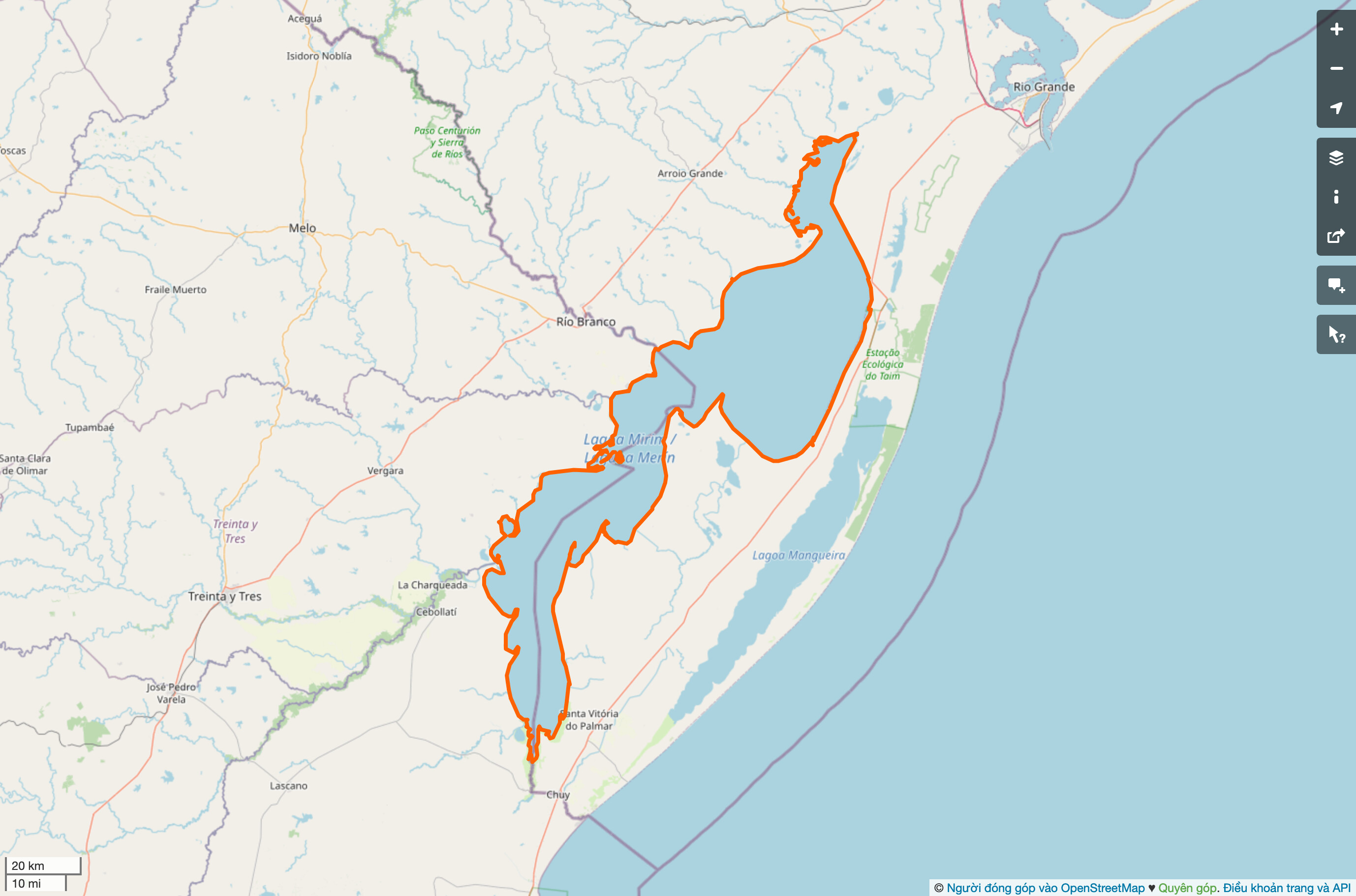
Would we call each of the 500 largest ponds ponds? Do you all have a different definition of pond across the pond?

Mirim Lagoon is hundreds of kilometers long.

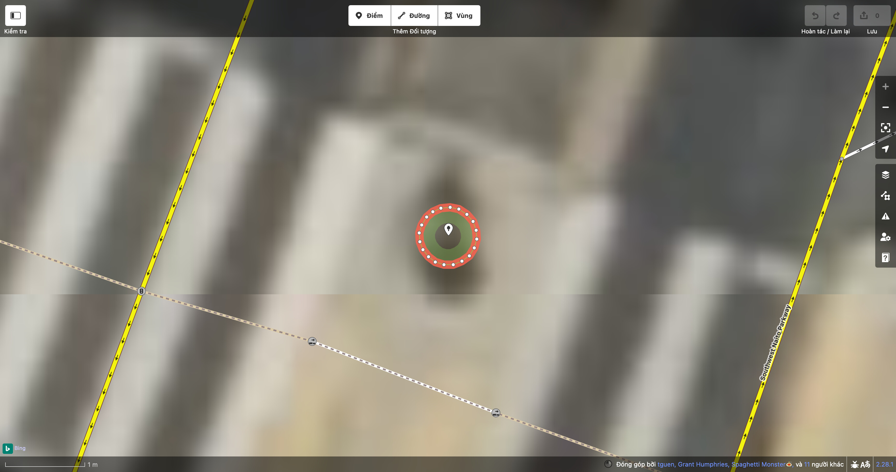
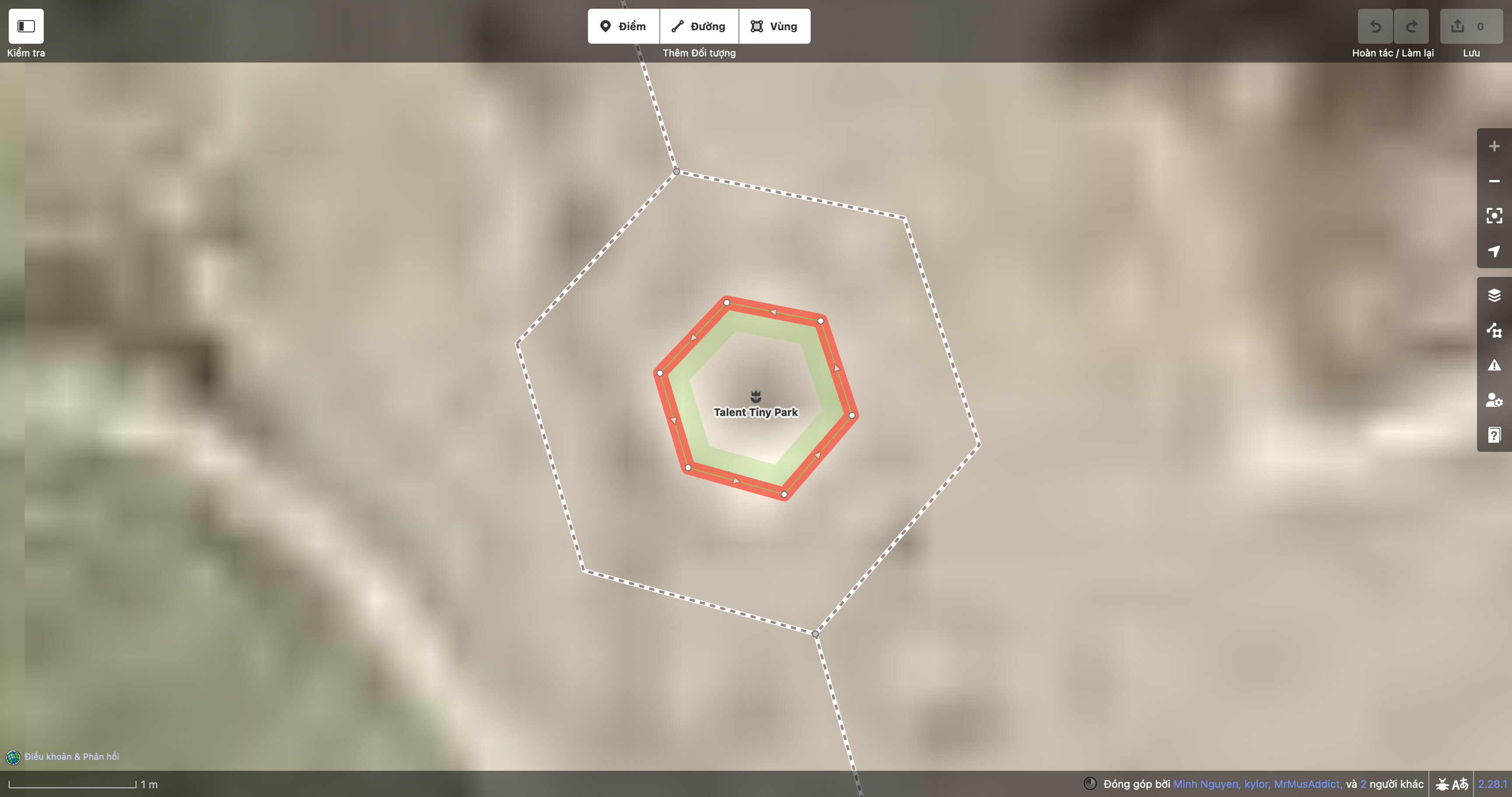
Of the 500 smallest parks, the smallest manages to cram all the amenities required of a city park in less than 9 square centimeters. The current official recordholder comes in at a mere 34th place, soon to be 35th:

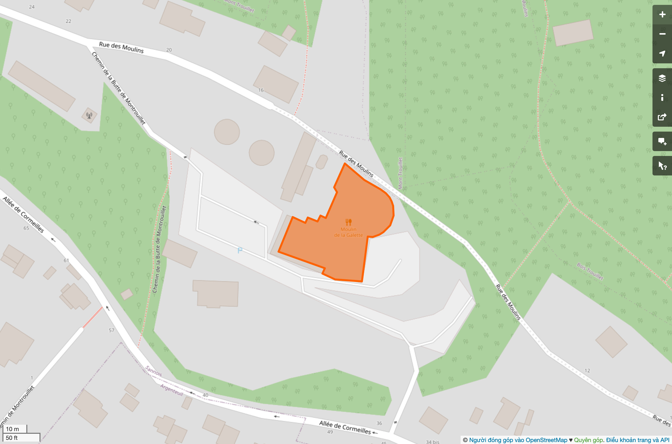
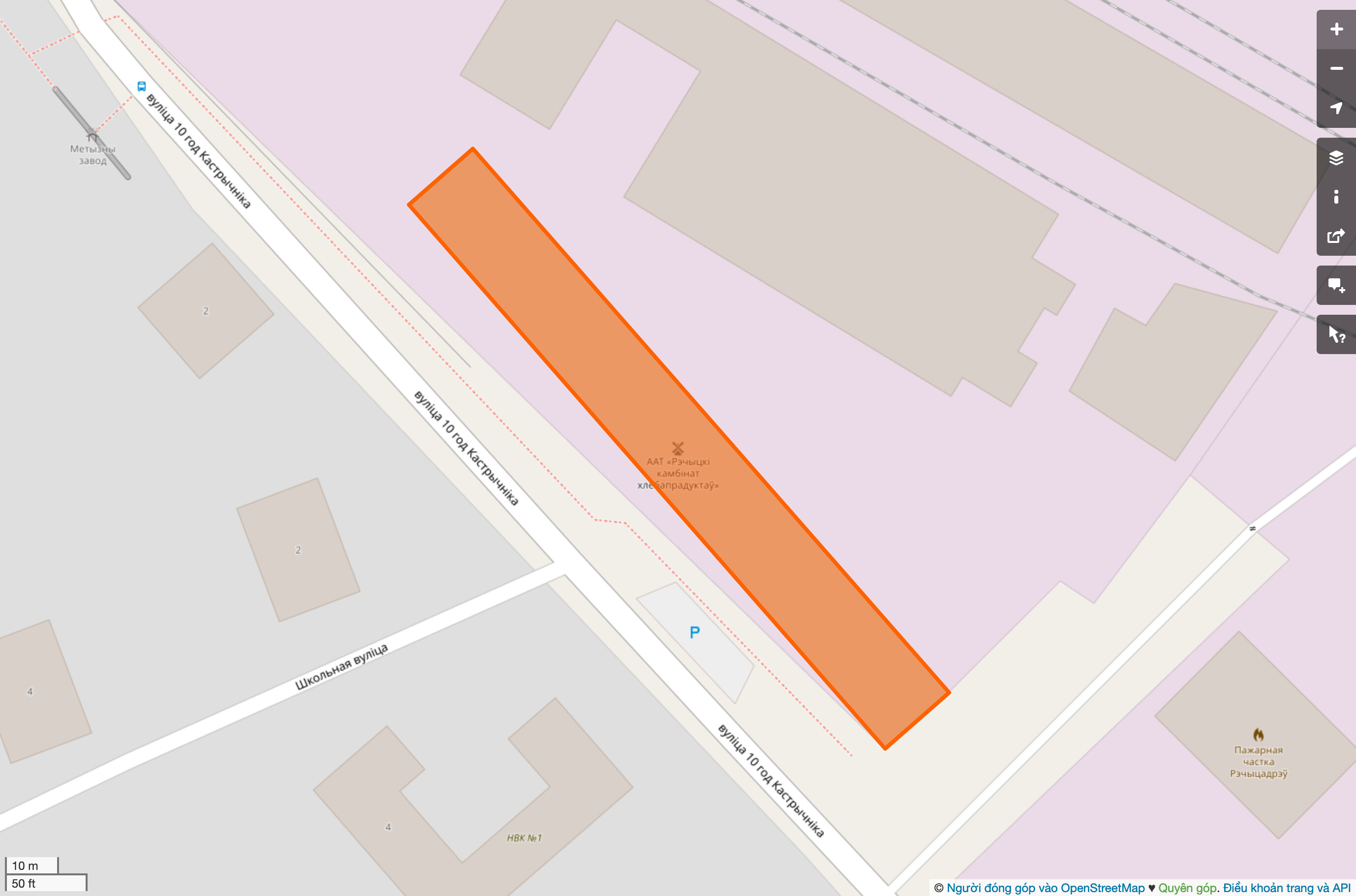
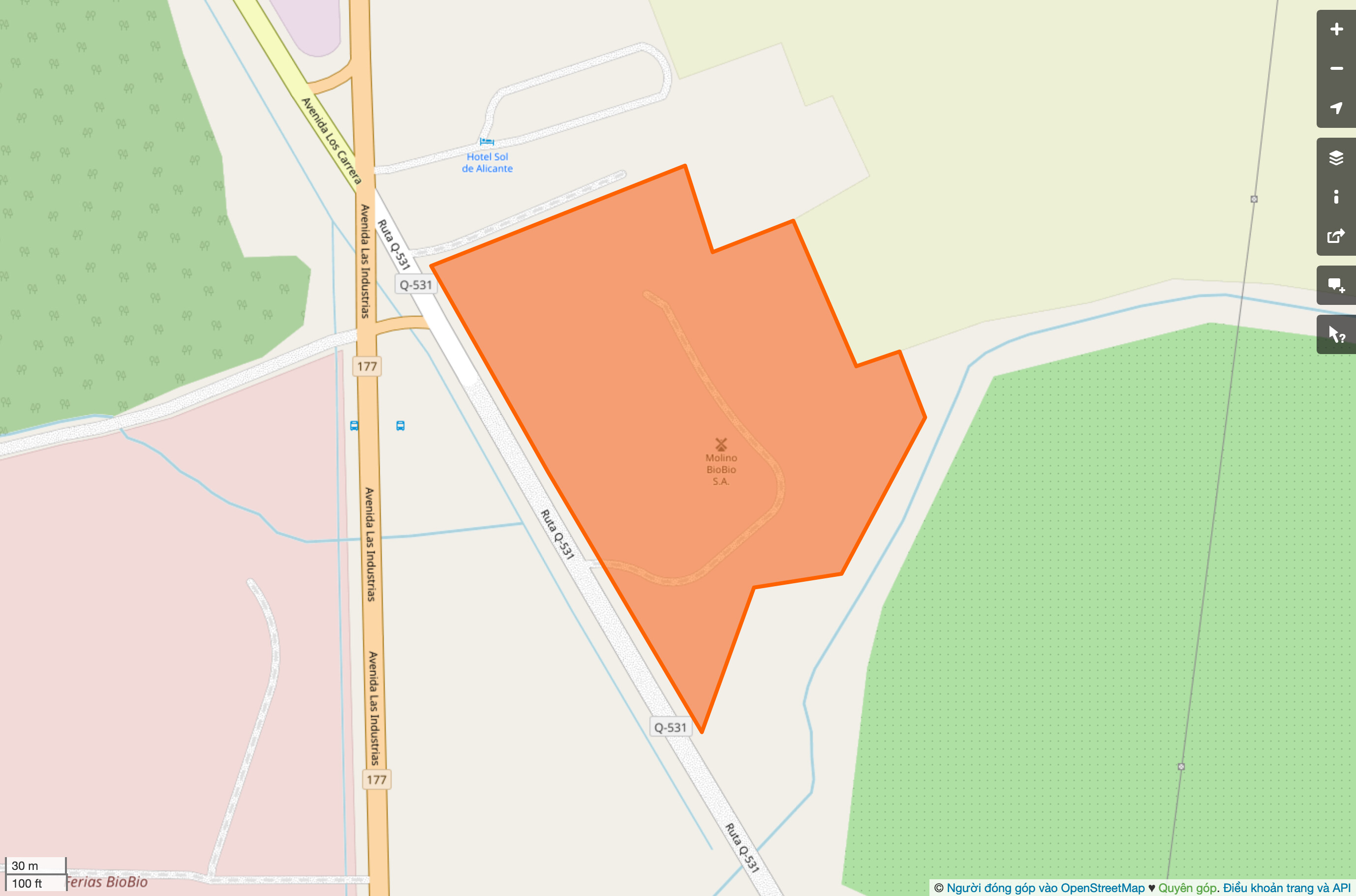
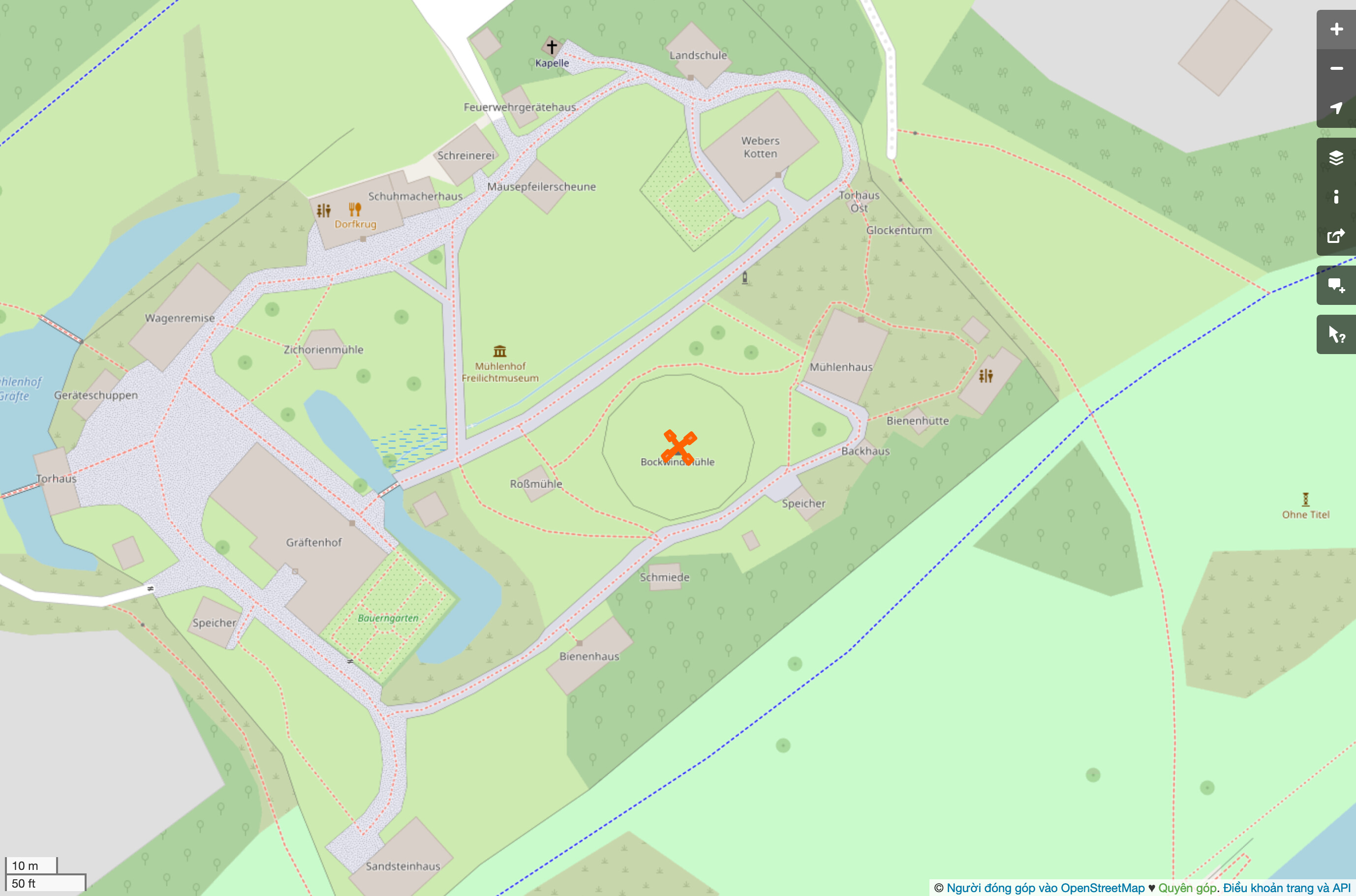
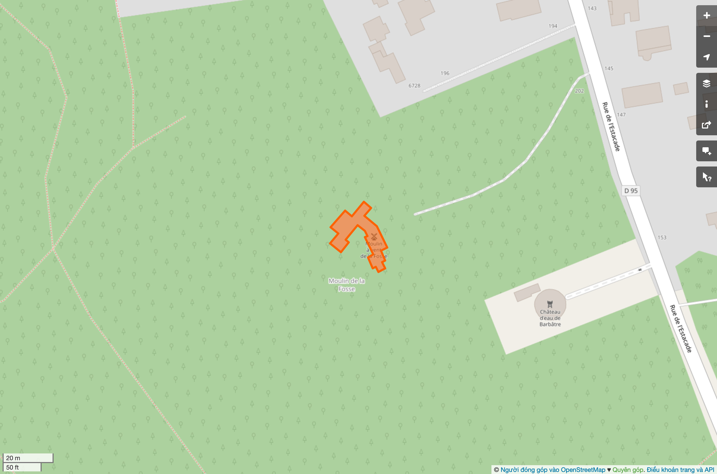
Some of the 100 largest windmills don’t have particularly wind-millable shapes:

An L shape resembling a boot.
A rectangle with about a 1:6 aspect ratio.
Let me ask ChatGPT to come up with a name for this shape.
The shape of a sharp obsidian dagger, perfect for milling… something…

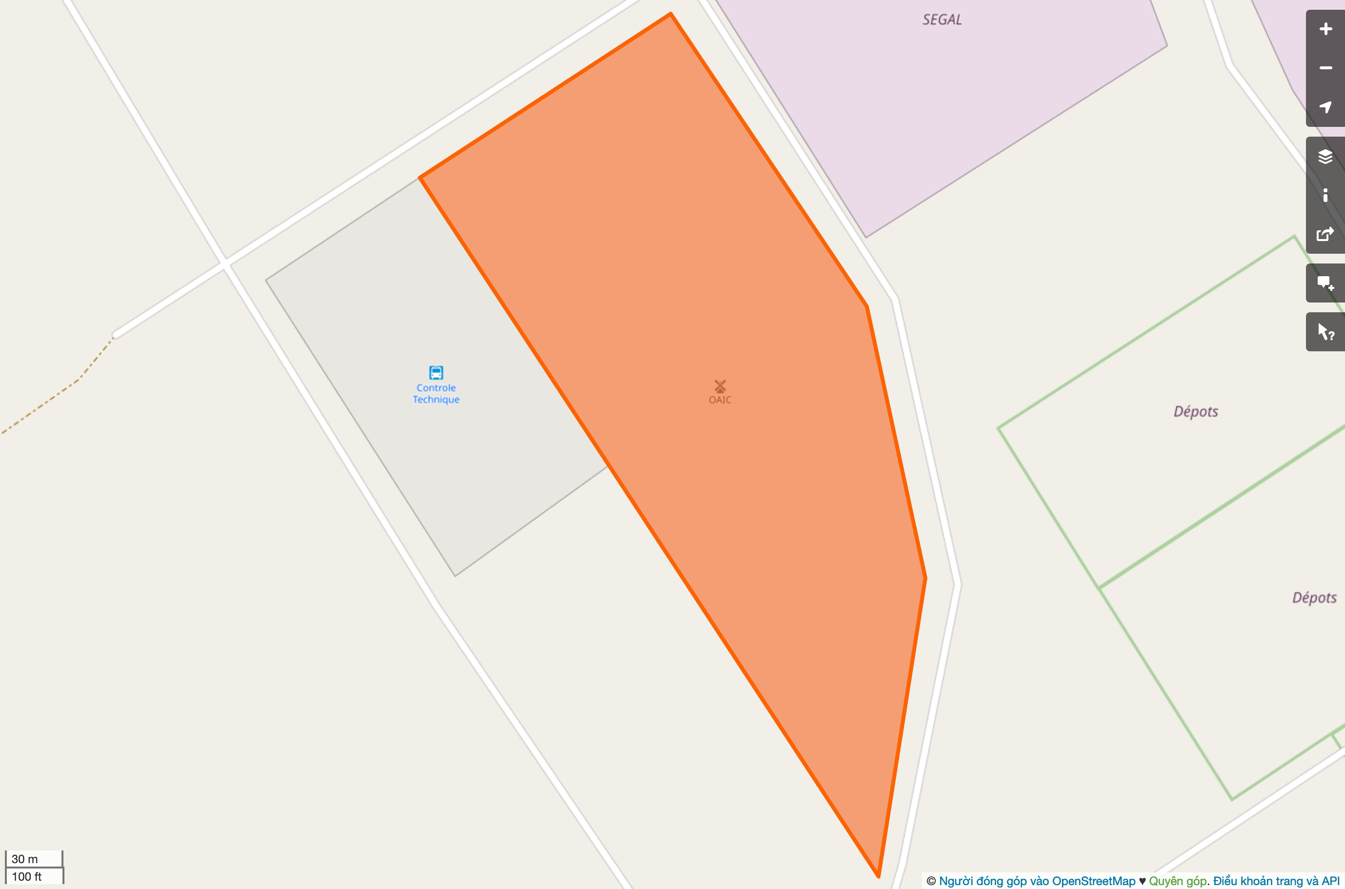
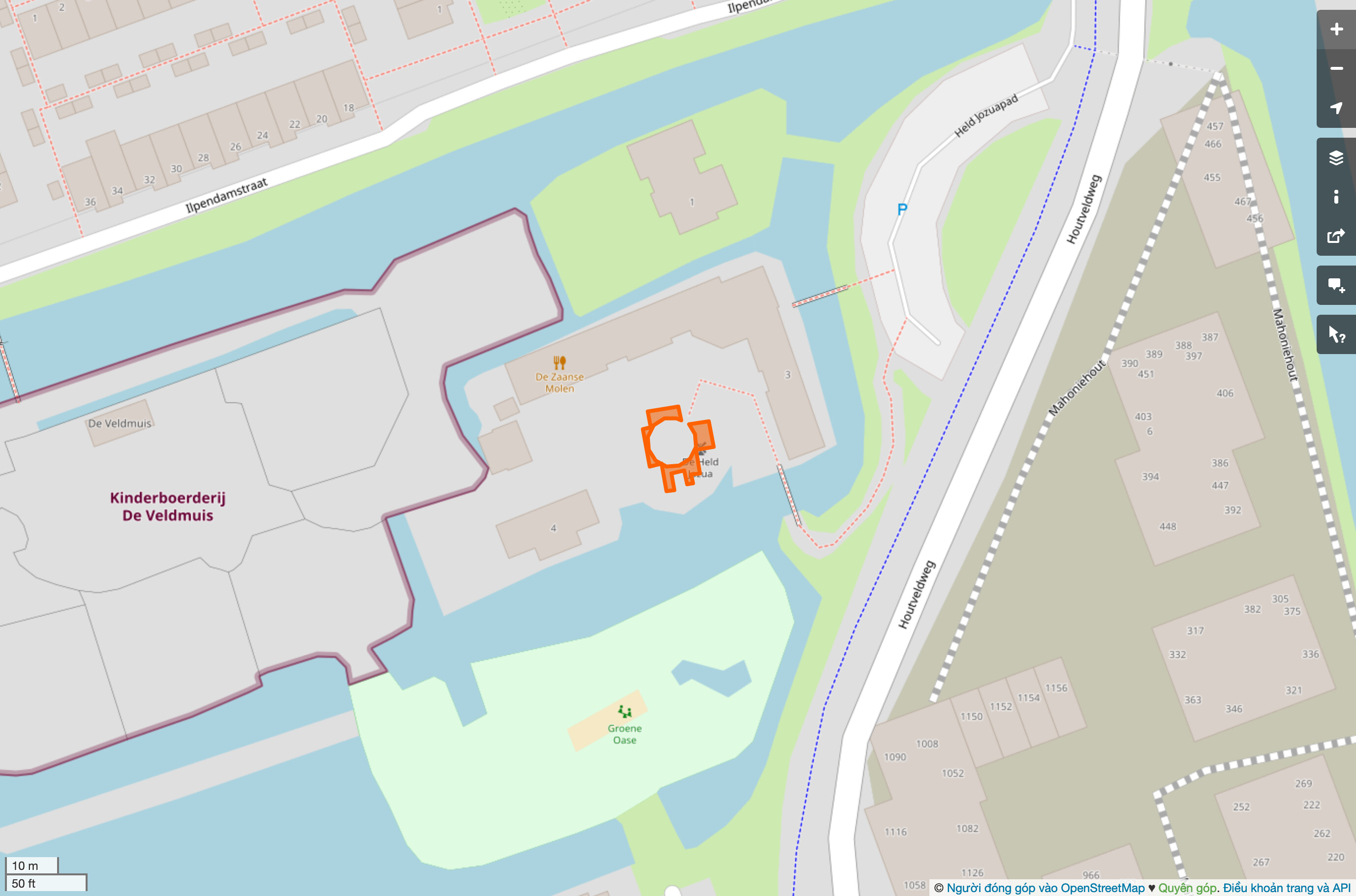
To find more unlikely windmills, I tried ranking them by Polsby–Popper compactness, figuring that a windmill ought to have a sturdy foundation.[1] The least compact windmill appears to be the result of someone mapping the blades as they lay on the ground:

A cruciform shape resembling the blades of a windmill.
A bizarre, many-sided shape with a circular hole in the middle where the windmill actually seems to be.
Another cruciform shape, this one much more faithful to the building footprint.
A jaggedy mess sort of resembling the number 7.

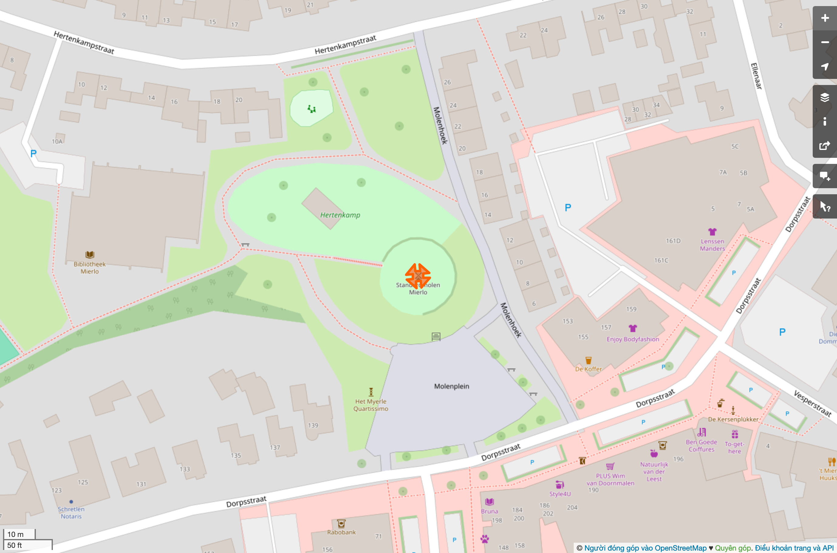
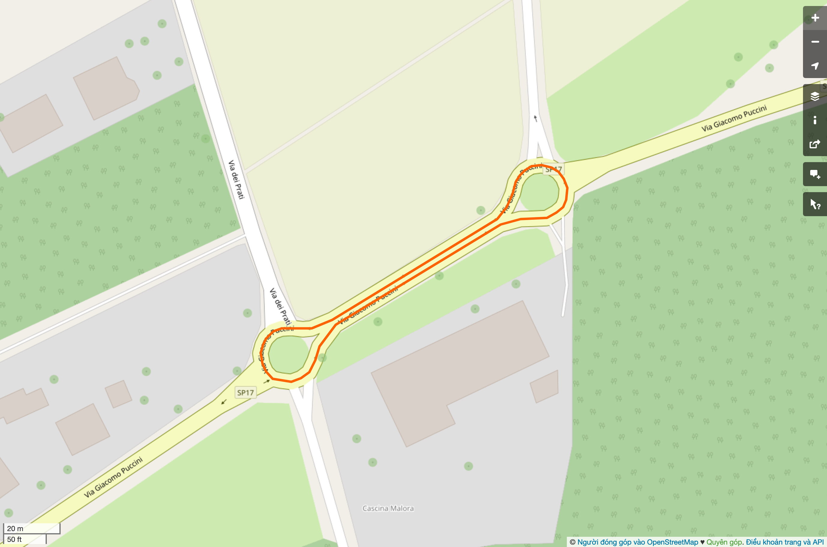
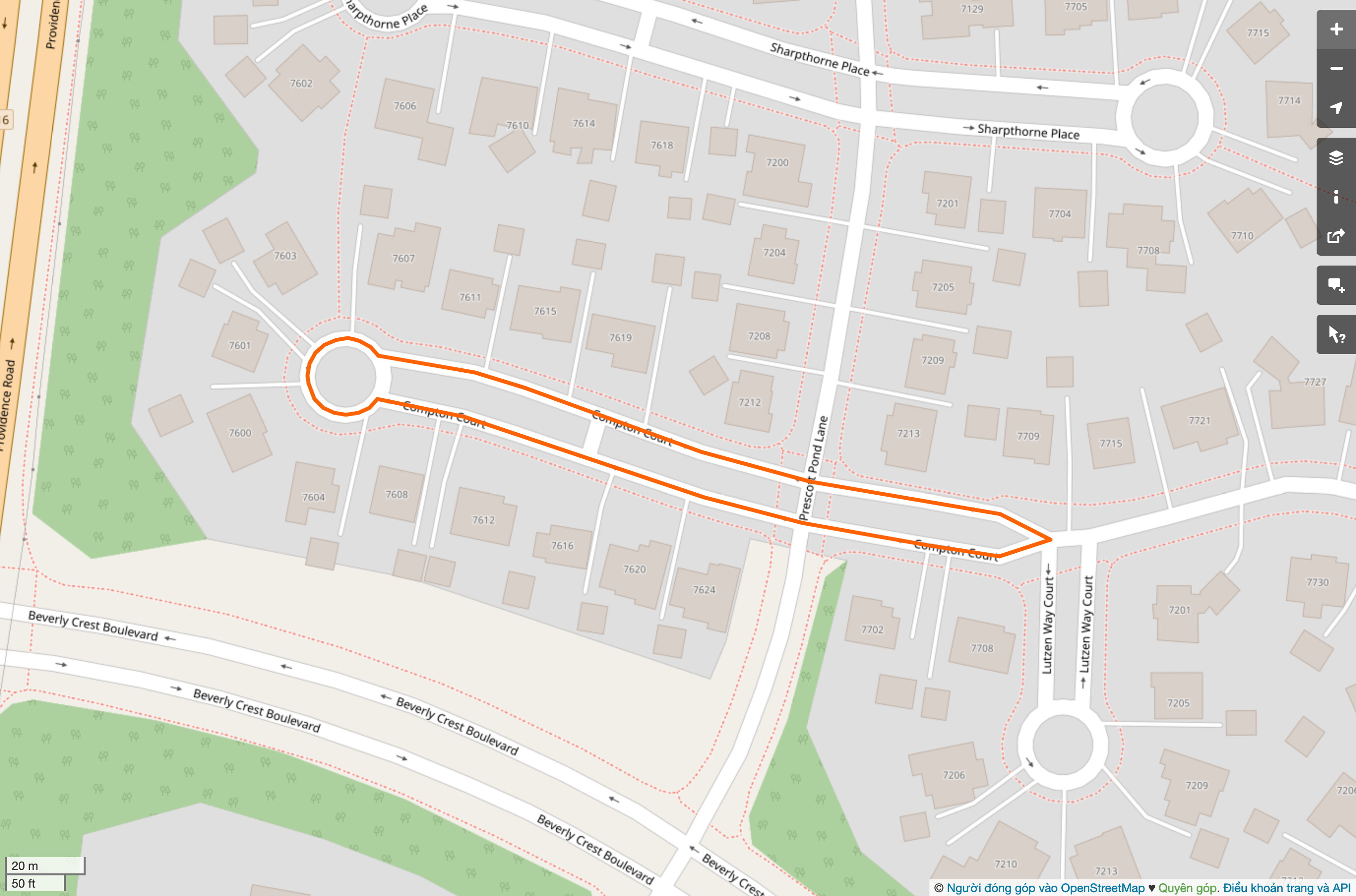
Now let’s see how well we draw circles. For kicks, let’s pretend that junction=roundabout and junction=circular are actually supposed to be round and circular, respectively.

A linear street six blocks long, divided by a median.
A delectable dogbone interchange.
A giant pushpin under construction.
The turning circle of Compton Court… and the rest of Compton Court as well.


  1. Incidentally, the Polsby–Popper test is a good measure of political gerrymandering. ↩︎

7 Likes

See also this 437437425.61 meters tall tree in Australia.
(Yes, I fixed it)

I simply looked for height tags that started with 5 or more numbers.

2 Likes

What’s even better is that it was mapped by “SanityChek” Changeset: 49391786 | OpenStreetMap

5 Likes

I’ve just converted most of those to boundary=national_park or protected_area, as appropriate.

I’m at loss for appropriate tags for this one, so I left it alone. Here’s its website:

Basically, it’s a forest containing a camping ground and many ATV trails, which is the main activity in this park. It’s hardly a leisure=park, and the best fit I can think of is a landuse=recreation_ground. But I left it alone for the time being.

Judging from the Bing imagery, the shape of the first one seems to match the actual shape of the foundation.

1 Like

Great idea! I think such plausibility checks are very helpful to find wrong tagged objects.

For the bench in particular, there are several attempts to build the longest bench in the world. Would be awesome to get rid of all wrong benches until your list shows all the attempts of building the longest bench… Hmm, I just realized that it’s according to the wiki it’s not recommended to tag benches as area but only point or way are suggested. I guess your script will not find ways?

Btw: have you considered publishing your script?

Edit: I just found that overpass can determine the length of a way. If someone interested, this is the query: way(if: length() > 100)["amenity"="bench"]({{bbox}});

right!
its called footprint

2 Likes

Exactly. In Nederland it’s called “standaardmolen”, literally “support mill”.
It’s a support structure with a mill building on top. The whole building can rotate on the support.

I’ve been playing around with that and it’s even easier than running my script!

This sort of query is also useful for finding examples where people put a “main tag” when they clearly meant a “side tag”: many of the biggest areas with amenity=toilets are probably campsites, supermarkets etc. with toilets, so a better tag would be toilets=yes. Same for defibrillators, but I think we don’t have a (documented) “side tag” like defibrillator=yes that just says this shop/amenity/POI has a defibrillator somewhere.

2 Likes