Step 3: the wiki is now a mess with that bit about the old license being incompatible… The wiki should include headings or pages for each import separately (example), that way the 2023 process can be linked to directly and we can tell the difference between the original and what is being conducted now.
Step 4: once the wiki is set, post to the mailing lists the normal way. Examples:
As @ElliottPlack already explained the wiki page still needs some work.
I currently do not find any info about height=* and roof:shape=*. It looks like the source only provides two values for roof:shape=*. Did you check if both flat and gabled are in sync with the OSM definition of the values? I wonder if there are not any hipped or more complex roof shapes and if all flat are horizontally flat and not skillion with only a small incline.
The source is from 2020 but in some areas available imagery like Bing is from 2022. In these areas a manual check against the newer imagery might be needed.
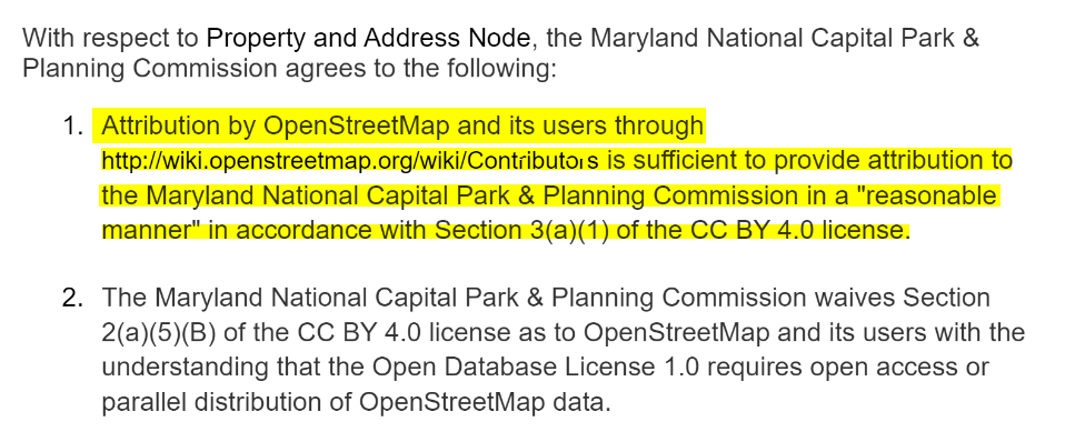
I’d recommend dropping the “use constraints” section since there can be no use constraints once the data is uploaded. The license waiver document you have linked covers this in item 1. I’d recommend linking to that and not writing any more interpretive language. I’d also defer to @SomeoneElse on the licensing discussion.
Secondly, for the example you’ve got, solid work here! Only modification is to put that output into JOSM, update the field names to OSM tags where ArcGIS Pro does not support them, e.g., ROOF_TYPEroof:shape and then Save As the layer and you will get an OSM file! Upload that to GitHub and use it in your example.
That section is now removed from the wiki. I will bring the data from the Github and bring it into JOSM, and upload that into Github and link on the Wiki.
Hi Skyper,
A new wiki page has been created for this import: M-NCPPC Import 2.0 - OpenStreetMap Wiki
As for the roof shapes, flat and gabled are in sync with the OSM definitions. The data source, is from fly overs, and in MOST cases will be more up to date compared to Bing. However, I agree there are some areas where this will be a consideration. These will be manually reviewed in JOSM.
roof:shape=gabled is used for any building which has not a flat roof.
Even where roof:shape=gabled might look appropriate it often counts only for part of the building and other building:part like garages have flat roofs.
addr:street=* is often incorrectly shorten and e.g. Lane or Drive is missing compared to the highway`s name.
height=* still carries a useless amount of digits after the decimal point.
Overall, I thought there should be two files, one for buildings without overlap of present data and one with the buildings with overlap of present data where conflation is needed. But I might just be wrong and misread the wiki in a foreign language.
Regarding @skyper’s comment about the height’s significant figures, there is no formal rule on this that I know of, but logic does apply here. Let’s take the height=3.14871060478 for example. The vertical resolution of the M-NCPPC LiDAR is only 10cm. Therefore, only the 3.14 (314 cm) is significant. You can round those off.
Finally, I see what @skyper means about the addresses. Have a look at this row. That is Rose Mount Lane (here) so just double check your address process is including the street type.
@ElliottPlack Thank you for the help! I have rounded the height and fixed gable vs gabled. I will also add the end of street names to the data. I will update here when those changes are reflected in GitHub
I would suggest, given the problems so far, that @M-NCPPC_Import really ought to create a personal wiki page with the content https://wiki.openstreetmap.org/wiki/Import/Guidelines, but with each line annotated to explain how what they have done has met that particular requirement. For example, following a certain amount of to and fro I think that we do have a licence waiver, but the line here is still comically wrong. Until that’s resolved I’d say we’re still at “Step 2 - License approval”.
Given that there does seem to be a general English comprehension issue here, perhaps @M-NCPPC_Import could ask someone to help them with that? I know that a couple of people on OSM US’ Slack have already helped with some points.
Unsure what line you are referring to. However, there is now a wiki page specific to this import, which has a link to the waiver that you indicated needed to be signed.
Some links between the two wiki pages would be appreciated.
Yes, looks better but there are still issues with the value of roof:shape. And is addr:state without any further addr:* useful on every building? Reminds me of is_in.
Regarding roof:shape:
What does the value not applicable mean?
I still find wrongly classified gabled which are either hipped or even more complex shapes.
In fact, this problem already existed with the first version of the import and roof:shape needs to be review on all buildings with value gabled.