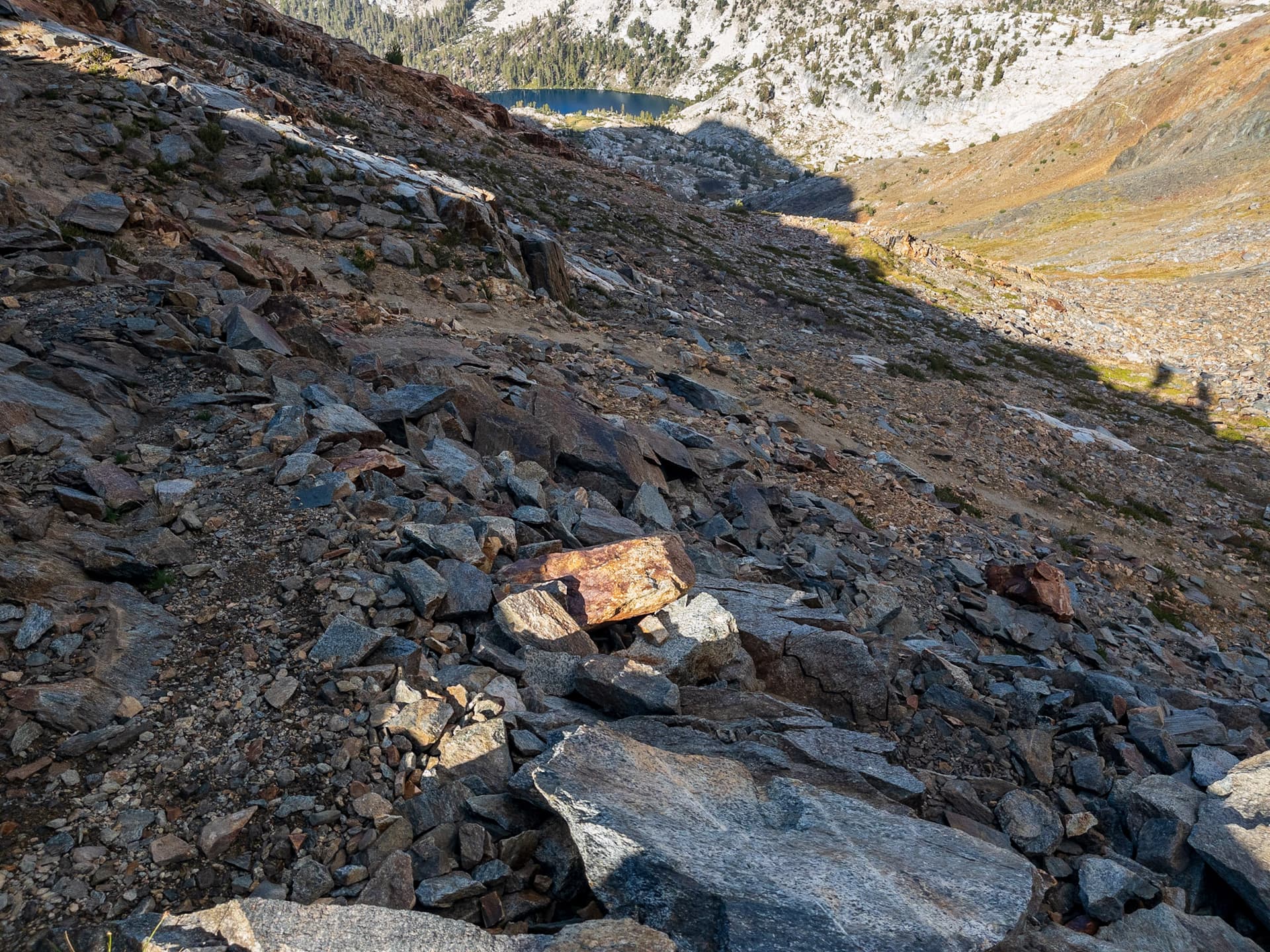
Both make sense, see my hiking path picture, but will the illustrating pictures still match the words? How about all the previous mappings on the old terms?
For me, all it would take is make the page no longer mention markers. If the markers work, people will see the path/trail See my second picture, the blazes make a horrible out of a no.
I second @yvecai - more words make matters worse: Why mention mapped paths? We are mapping! Why mention which way to follow at a crossing? I hope nobody ever understood the key like that!
Edit to add: The combination of no trail_visibility and marking other than no should continue to make sense. It doesnt do that, if trail visibility is already a mix of both.
I think given the massive differences in opinion on what the original wiki page meant, including the fact that the current consensus is the opposite of it’s original intent is an indication that clarification is needed.
Yup.
I agree on principle, but since it (according to consensus here as well as data analysis) is being used as route/path_visibility it is what it is. I think bowing to what this is, and then proposing a trail_surface_visbility might be the most practical path forward.
The existing documentation already allows it for excellent and good, so that ship has sailed. Not having it below there is a strange inconsistency.
This seems reasonable to me, and the “mapped trail” I think helps clarify the semantic disconnect people (like me) have between a trail and formal OSM highway=path.
That unfortunately would make breaking changes with how it is currently written / being used.
“mapped paths” is to clarify that trail_visibility is not actually trail_visibility, but the visibility of the overall path shown on OSM.
The description of excellent currently is “None, orientation unproblematic, no map required”. I like the following point and would change it a bit. “None, orientation unproblematic, no map required. It would still be easy to follow in poor weather or at night with a personal light source.” (gets around torch, headlamp, flashlight).
Good makes less sense to me. If a trail is a “Continuous established path, always visible” then why is a basic sense of direction required? “Path always visible, but sometimes has to be searched for” makes more sense to me and is less likely to break current usage. Perhaps “A continuous established path which is always visible but occasionally has to be searched for. Could be difficult but possible to follow at night or in poor weather.”
Intermediate is a sentence fragment that doesn’t make sense:
“Path mostly but not always obvious/visible” mostly what?
Intermediate should probably be fleshed out to "The path is often not obviously visible, but can be found after searching. In poor weather or at night the path might not be followable and orientation/routefinding would be required.
Bad could be "The path is often not obviously visible and occasional stretches of the mapped tail may be completely pathless.
I am curious as to what the different between being “mostly visible” and “sometimes invisible” in intermediate and bad. It seems like they’re describing the same thing - something which is mostly visible is sometimes not visible. Adding in some sense of frequency seems to keep with the original intent and wording while making things clearer.
Skills in orientation vs orientation skills should also just be normalized to one or the other.
[...] but also human-added clues such as trail blazes, poles and cairns.

[...]

The key is not about route visibility (how easy it is to choose the right trail at a trail junction) and quality of trail marking. See [trailblazed:visibility](https://wiki.openstreetmap.org/wiki/Key:trailblazed:visibility)=* for attributes regarding trail marking quality.
Huh?? the key isn’t about markers, like trail blazes, poles, and cairns, but is about clues like trail blazes, poles and cairns?
The usage “route visibility” is still weird to me. Even in Europe “route” is used to refer to low/no visibility paths, see the Austrian system, or the OMS wiki page describing climbing routes.
(I can’t post more than 3 links, and can’t post another reply, so remove spaces above)
“Alpine routes:
These are not hiking trails – they lead into alpine or high alpine terrain, and can contain sections that jut out, pose a risk of falling, or are unsecured.”
Using the word route doesn’t automatically refer to the relationship of paths.
Routing, or route relationships, or navigation between paths would be clearer IMO.
The different between ground and landscape for path visibility also seem a little unclear to me. A level or slightly sunken surface I would just think of as the ground.
Something like:
The key trail_visibility=* is used as part of a classification scheme for hiking trails and paths. The key describes how easy it is to follow a mapped trail using all available visual aspects of a path. These aspects include the visibility of the path on the ground (differences in surface of the trail vs. the surface next to it, differences in vegetation, a leveled or concave path surface, a treeless corridor through a forest, etc.) as well as human-added markers such as trail blazes, poles and cairns.
It is based on the classification of the Swiss Alpine Club (SAC).
The key is not about routing visibility (how easy it is to choose the right trail at a trail junction), as that is covered by guideposts.
If a path does have markers they should be indicated in via trailblazed. See trailblazed:visibility=* for specific attributes regarding trail marking quality.
Base on your description, there are only markers. The fact that there are no trails means that including a trail related tags is just confusing. This is more a matter of orienting between marked way points.
I’m not sure what you’re referring to, but trail_visibility (not as originally intended) is being used for paths that consist solely of markers with no trail surface. This has been explained a few times in this thread.
I personally wouldn’t consider routes that don’t have any trail surface and consist only trailblazed=horrible trails or paths, but there are many formally maintained and recognized trails that consist only of markers that are well spaced and easily visible.
Is it worth having a cut-off for a “path/trail” that consists of only sporadic markers (no and horrible, possibly bad)? I feel like an abandoned trail with some come and go surface trail is more legitimately a path than a cairn every 30-100 meters, or ones that are informally and inconsistently made. This might actually have been the original intent as markers were only mentioned on good and excellent trail_visibility. Anyone can stack up a few rocks on a pathless route and just call it a trail.
I think is reasonable to reduce trail or marker quality based on a combination of quanity and quality. As for a lower threshold, that may be a slippery slope. Pun aside, it is hard to set a clear cut-off where a trail becomes useless.
trail_visibility=no indicates a mostly pathless trail.
There’s no guidance on what that means - if there’s three informal cairns over a kilometer, does that constitute a trail? If it does then anyone can create a “trail”.
In my mind there should at least be some significant stretches of a visible path - coming over Red Pass in the Sierra Nevada there’s an old trail from a historical Sierra Club pack group + recreational users over the years that is clearly visible in places and can be followed for tens of meters before it fades then appears again, there’s some visible rock work on switchbacks. That’s not currently marked as a trail in OSM (and I don’t think there’s a lot of utility in doing so as it’s easily navigable terrain for anyone that got that far) but I could see just mapping those areas where the path is visible, then having it start, then stop again as matching ground truth. Creating an arbitrary path that leads all the way to the pass down to Marion Lake seems less palatable.
note: this isn’t visible by satellite, and I wasn’t recording a GPX track and starting / stopping it (and I’m not sure that I would have found all existing paths) so can’t add it in.
Trail visibility of horrible is “often pathless” - what does that mean? Presumably less than 50%, given that it isn’t “mostly pathless”. If there doesn’t have to be any trail surface present (like there is in the example photo) then a few cairns here and there can constitute a horrible path.
Obvious and visible are not synonyms in terms of intermediate visibility, is something “invisible” or just “not obviously visible”. The idea of an invisible path is sort of amusing. I’d argue that “faint” or “hard to see at times” would be more appropriate than “invisible” for intermediate unless it’s for very short periods.
What is the difference between “Path mostly but not always obvious/visible” and “Path sometimes invisible, mapped way partly pathless”? They seem to be describing the same thing to me - if a path is sometimes not visible, then it is by definition invisible and partly pathless.
Ah sorry, I meant trail_visibility there. I’ll edit the comment - I’m hopping between threads catching up on comments. The (unrefuted) argument still stands, but thanks for catching the typo.
If `trail_visibility=no’ can indicate a path with no surface just markers, then no and horrible would seem to map to the following on trailblazed:visibility:
horrible: trail markers exist but are rare or hard to locate
no: trail markers almost not exist and/or they are so rare that they are close to useless
So trail_visibility=no could be mostly pathless (with no visible signs of human passage on the ground) with trail markers that almost don’t exist and/or they are so rare that they are close to useless. How is that a trail/path in any realistic sense of “ground truth”?
This is more of an issue now - when the tag referred to the trail surface it’s visibility could be “no” while the path also had trailblazed:visibility=excellent (or good or intermediate) which would still clearly indicate a path.
If we are formally collapsing surface and markers together, then a path existing with no visible signs of human passage on the ground and with trail markers that almost don’t exist and/or they are so rare that they are close to useless doesn’t make sense to me.
IMO if something resembling a path exists for 5% of the mapped trail then that 5% should just be mapped - the rest would be a pathless route needing routefinding and having, say, a 2-3km trail when there’s 100m of path doesn’t seem appropriate.
The proposed text also conflicts with how this tag is represented in the OSM editor - no is considered “pathless” there (e.g. a route), not mostly pathless. That’s a significant difference.
Take the example closer to the other edge case - when there is 19km of trail, but “only”18700m of visible path, then it seems more appropriate to tag that 300m which is pathless (e.g. due to weather washing away the visibility of the path/makers with mud etc. and not being renewed) as trail_visibility=no, to indicate that you can actually pass there (but only if you know where you’re going).
I think the idea is to help the routers (apps) – because, if there was 300m unmapped empty space between two paths, the routers will assume the terrain there is impassable, and would (instead of routing over “invisible”/unmapped 300m) happily send you on e.g. 30km detour around the mountain (i.e. on actually mapped highway=path way); which would be (for hopefully obvious reasons) not optimal solution.
I got around to adding an informal “trail fragment” that I’ve been thinking about for a while and felt would illustrate some aspect of this discussion.
One could theoretically create a path all the way from Bearpaw Lake to either the peak or pass beyond (but, since things need to routed, one over Italy pass, white bear pass, then down into bear lakes basin, meeting this trail, over feather pass, then down to Miriam lake etc lol) but that’s all very open fairly obvious terrain with no signs of a path and the overall visibility would be horrible. There might be a subjectively placed informal cairn here or there, but nothing decisive.
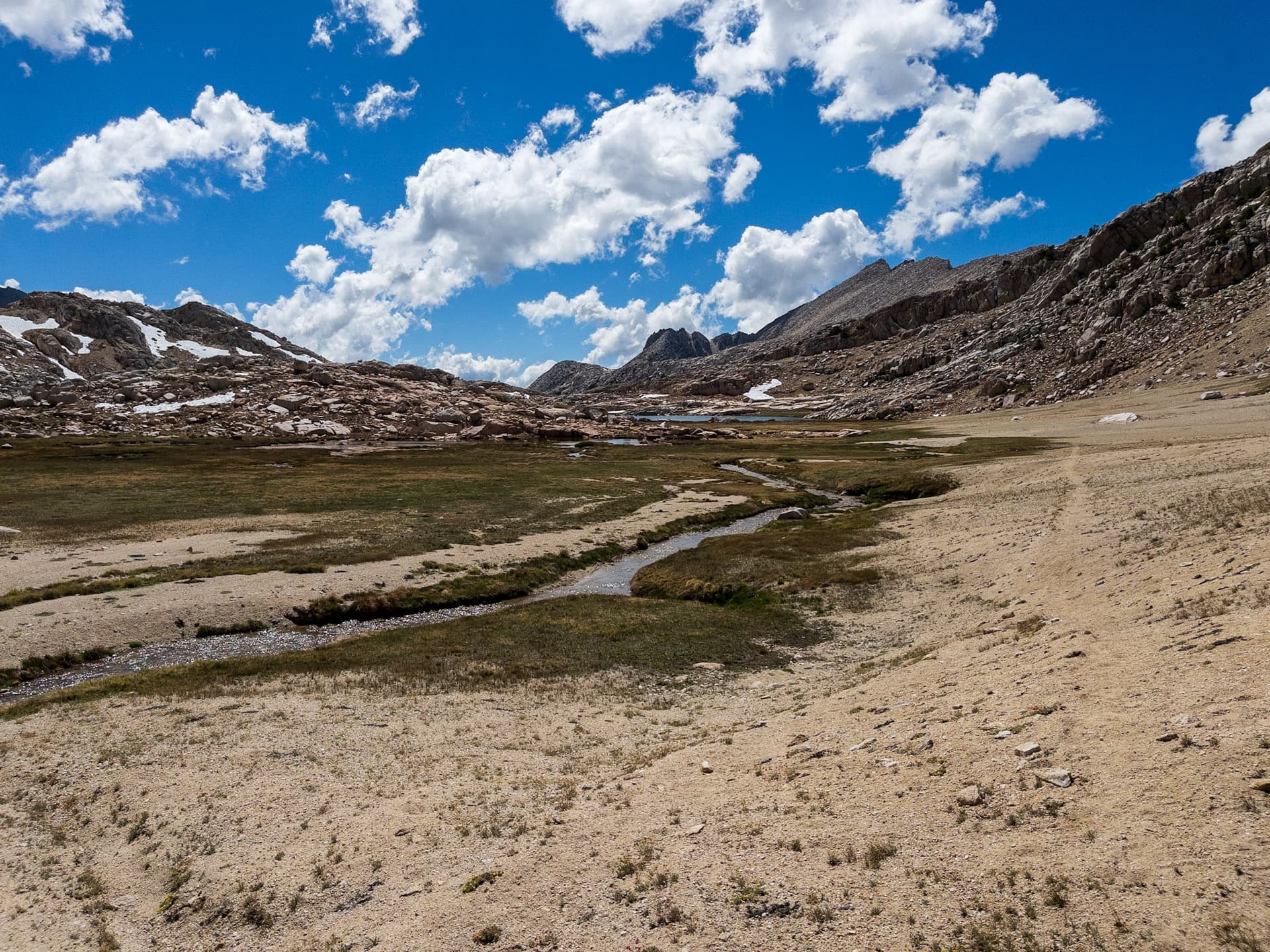
There is a clearly worn rut through this sandy area that has ground truth for a path. It violates the rule that everything has to connect and has to be routable, but to me feels like the best way to approach this issue vs faking paths to cover all possible routes.
In that case splitting the trail into multiple segments would tell a clearer story (the 99% which is good or excellent) and the 1% which is no rather than saying that the overall trail is intermediate or bad, though either of those would also apply to your use case above.
It’s an interesting disregard of ground truth / verifiability as a principle. I would personally put routing below ground truth for informal trails/paths as in the example above, as disregarding that just leads to a lot of fake paths. For formal paths disregarding ground truth for short segments for the sake of routing makes sense.
There are existing informal paths on OSM which are essentially a few kilometers of pathless terrain with a handful of informal cairns. They generally start from a path, but they aren’t just a short connector between paths to create a route but are technically valid. Having some disclaimer that pathless paths should only exist as commonly used connectors between actual paths would seem reasonable to me.
iD.
Honestly having visibility “no” be entirely pathless makes more sense to me than “mostly pathless” from a semantic / intuitive standpoint. I’m not sure if the Wiki or iD editor is used more as a reference, but that is a noticeable inconsistency.
Yes, absolutely. Sorry, I was thinking that was taken for granted. Like if the surface was 99% asphalt and 1% dirt, of course one would split that way and tag each one separately to indicate that!
Yup. There is informal=yes too (as well as note=* for notifying fellow mappers how to proceed when some situation is not obvious)
It depends. In my experience, mappers will most often bother to add such “fake paths” only if there is no passage marked on OSM at all, and they want to indicate that it can if fact be traveled.
Once the first “fake path” that connects more discernible points “A” and “B” is mapped (usually, that seems to be the shortest traversable way between them), much more rarely (if at all) do new alternative “fake paths” pop up (although the mapped “fake path” might get moved few meters here or there from time to time)
This applies equally when the paths are not “fake” but actually visible on the ground, but numerous in short distances (e.g. unmarked forest paths). Especially with constrained/coarse GPS signal under canopy.
So hiking apps (e.g. Komoot) do allow you to plot “off-grid” routes. Useful for calculating total ascent/descent, to get a very rough estimate of travel time, etc. This should in theory reduce the need to add “fake” segments just for the router
Yes, I don’t generally see paths for all possible routes over terrain either once one is in an area.
It does create the issue where people will try and follow the path that shows up on OSM (I’ve done this myself, though I generally find out pretty quickly there’s nothing to it and just routefind on my own) where no path exists. This can create erosion, or destruction of terrain where having people spread out their impact if there isn’t a “path” to follow. This has happened a few times along Roper’s SHR (though you could argue that it’s also increased use) where passes that used to be pathless now have a social path on them after GPX files were shared online, which detracts from the wilderness experience and goes directly against the intent of the person who created that route.
I could create kilometers of pathless path to extend the feather pass/peak above, but I feel like it’s best as just a fragment (the impact is already there, on some level it shows people have made it that far).
I’ve been tagging a lot of poor visibility social paths with this (where there is actually some ground truth). I’ve been deleting ones that are just “I did this” and there’s no sign of a path, after reaching out for advice or the original author if possible.
Gaia GPS and Caltopo allow this in the US market.
I also feel like having to manually set off trail routes isn’t a bad thing, it keeps people from getting in over their head.
After looking at the trailblazed:visibility page (which is a lot clearer wording in my opinion), the iD editor, and comments here I’d propose these for new visibility descriptions:
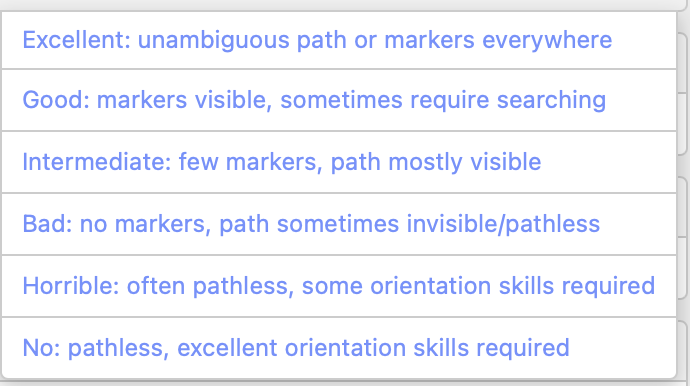
trail_visibility=excellent
Unambiguous well-constructed path everywhere. Easily followable when visibility is reduced.
None, orientation unproblematic, no map required
trail_visibility=good
A continuous path which is always visible but occasionally may have to be searched for.
Basic sense of direction, map recommended
trail_visibility=intermediate
Path mostly easily visible, but has short sections where it is hard to find.
Good sense of direction, map required
trail_visibility=bad
A path mostly exists, but the mapped way is partly pathless and you need to be able to find the path again.
Basic skills in orientation
trail_visibility=horrible
Often or mostly pathless, signs of a path exist but are often rare or hard to locate.
Advanced orientational skills
trail_visibility=no
Pathless (should be used for short segments between paths to help with routing).
Excellent orientational skills
The bright line around intermediate seems to be the hardest to define, I tried not to change the line too much, but I feel like this has more clarity to it. No is my opinion, and refers to pathless paths / routes which has it’s own topic.
The text in the iD editor needs some tweaking too, Bad doesn’t necessarily mean no markers.
There’s also the contradiction on whether this includes markers or not on the talk page, I also condensed down ground vs landscape wording, fixed references to “routing” etc for the text up top.